
From Piazza della Repubblica to Porta Spoletina
Leave Piazza della Repubblica with Palazzo Comunale and then Piazza Solferino on the left and Piazza Europa on the right and continue along Via Garibaldi. This was the decumanus maximus of the Roman city.

Return to Via Garibaldi and turn right. The medieval Porta del Sesto (later Porta Garibaldi) probably stood near the junction with Via delle Conce (on the right) and Via San Nicandro, at or near its Roman predecessor. The gate had been replaced by a customs barrier by the 1930s and no trace of it now survives.
Take a short detour by continuing along Via Garibaldi to the bridge over the River Nera that was known as Ponte Sesto (now Ponte Garibaldi). Both the bridge and the gate were named for Sextus Pompeius, who was said to have built the original bridge here in Roman times. The present bridge was built after its predecessor was destroyed in the bombardment of the Second World War.

Retrace your steps to the junction of Via Garibaldi and Via San Nicandro. Turn right along the latter: this street is named for the church of San Nicandro (13th century), which passed in 1291 to a confraternity that became known as the Confraternita di San Nicandro. The church was demolished in 1950. [The nearby nunnery of Santa Monica was demolished - when?]


Walk along the side of San Giuseppe and then right along a second side of Largo Pietro Manni. Turn left along Via Chiodaioli: this street, previously Via Clai, is named for the nail makers who supplied the local shoemakers. There are three interesting turns to the right:
-
✴Vicolo San Procolo was probably named for the Franciscan nunnery of San Procolo. Take a short detour along it and turn right, Via Sant' Andrea, which was named for a church of that dedication (mentioned above) that was destroyed by the bombardment of the Second World War. Andrea Castelli and his sons were buried here after Braccio Fortebracci murdered them in 1415. Return to Via Chiodaioli.
-
✴Piazza Clai was at the heart of one of the most vibrant quarters of the medieval city.
-
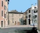
✴Via del Comune Vecchio is named for the Palazzo del Comune (1292-1302), which was built at an unknown location nearby. Tradition has it that the house in Piazza Clai depicted here, which backs onto Via del Comune Vecchio, stands on the site.
Continue along what is now Via Tre Archi to the junction with Corso Vecchio, the cardo maximus of the Roman city. Turn right and continue to the triangular Piazza Corona, which was once the Jewish quarter of the city. The Roman gate at the north end of the cardo maximus probably stood in Piazza Corona. Its successor must have been demolished when the new walls were built in ca. 1354 (see below). The piazza was also the site of four other monuments of which no traces survive:
-
✴the Arco di Domiziano (late 1st century AD), a Roman arch erected in honour of the Emperor Domitian (81-96 AD), which was documented in the 17th century and recorded as in ruins in the 19th century;
-
✴two buildings that belonged to the Confraternita di San Nicandro:
-
•the church of San Cleto; and
-
•the adjacent Ospedale dei Pellegrini; and
-
✴the church of San Nicolò, which was documented as “foris portam” or variants thereof in the period 1275-1372, but as “inter portas” in later documents (from 1429) . This suggests that it was outside the first walls of Terni but enclosed by the new circuit in ca. 1354.
The nearby gate in the new circuit of walls, Porta San Giovanni, was named for a nearby church that was described as ancient in the 17th century. No trace survives of either the gate or the church, although Via Porta San Giovanni on the right commemorates the former. Walk a little way long it, to the junction with Via Castello: this was probably the site of the new gate.
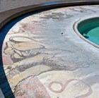
Turn left along Via Castello into Piazza Buozzi: a Roman necropolis (which would have been just outside the Roman walls) was excavated here in 1999. Turn right across the piazza: Viale Benedetto Brin ahead leads to the industrial complex outside Terni.

From Porta Spoletina to Piazza della Repubblica
Turn left along Viale Curia Dentato (or right if you have returned here after the detour). This busy street was built in the 19th century to link the railway station (see below) to the the industrial zone outside the city. It is named for Manius Curius Dentatus, who built the Cascata delle Marmore in 272 BC.

-
✴the historian Gaius Cornelius Tacitus (died ca. 117 AD);
-
✴the Emperor Marcus Claudius Tacitus (275-6 AD); and
-
✴his half-brother and successor, the Emperor Florianus (276 AD).
Turn right along Via Domenico Mascio, cross the piazza in front of the modern Alterocca complex (named for the Poligrafico Alterocca - see below) and continue along the footpath into Piazza Dante Alighieri, in front of the railway station.

Turn left and left again along Viale della Stazione, which takes you back towards the centre of Terni. Continue to the junction with Via Marco Claudio on the left, which is named for the Emperor Marcus Claudius Tacitus. (The edicola on the opposite side of Viale della Stazione sells English newspapers).
The print works known as the Poligrafico Alterocca, which Virgilio Alterocca built in 1877, extended along Viale della Stazione from Via Marco Claudio to Via Floriano (which is named for the Emperor Florianus). The ancient necropolis of San Pietro in Campo occupied this block and the next one, which extends to Via Tre Monumenti. The necropolis is so-named because the area was known as the Contrado di San Pietro in Campo, presumably because there was a church of that dedication nearby.
-
✴The first tombs of the necropolis were discovered near the junction of Viale della Stazione and Via Tre Monumenti in 1907.
-
✴Some 50 tombs (ca. 720 - 580 BC) were excavated nearby in 1910-12.
-
✴The demolition of the Poligrafico Alterocca in 1966 provided an opportunity for further excavation of the necropolis.
-
✴Two campaigns, in 1998 and 2000, revealed the existence of a further 46 tombs that had been in use in the decades around 600 BC.
Finds from the excavations of 1910-12 and 1998-2000 are exhibited in the Museo Archeologico.

-
✴Mario Ridolfi and Mario Fagiolo also designed the three-tiered civic fountain, which has a tall steel spire at its centre to symbolise the industrial heritage of the city. It was destroyed during the bombardment of the Second World War and rebuilt in 1961. Corrado Cagli designed the polychrome mosaic in the first basin which depicts the signs of the Zodiac. The fountain was restored in 1994, but the mosaics are still in a very bad state of repair.
-
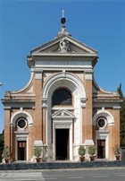
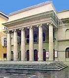
✴Cesare Bazzani designed the neo-Classical Palazzo del Governo (1930-6), which is on the left, just before the piazza (on the right in the picture below) after Terni was designated as the second provincial capital of Umbria (after Perugia) in 1927. It is still the headquarters of the Prefettura and Provincia di Terni.
The tourist office is at number 4 Via Cassian Bon, which is the road to the right as you leave the piazza.


Take a short detour by continuing straight ahead on leaving the church into Piazza del Mercato Nuova. The market was moved here from Piazza Solferino (see below) in 1960. This was the site of the Franciscan nunnery of Santa Caterina, which was documented in the 14th century. It was closed in 1845 and the complex was used a a school until it was destroyed in the bombardment of the Second World War.
Return to San Cristoforo and turn right along Via Angeloni, with Largo dei Banderari on the left. This space is named for the body of 24 magistrates drawn from the middle classes that revolted against papal control in 1564. Continue along Via Angeloni to the junction with Via San Tommaso on the right.


Continue to the end of the street, which rejoins the car park. This was the Monastero di Santa Teresa until its demolition after the Second World War.

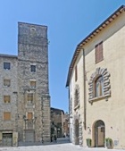
Turn right on leaving the church and along Via Anastasio De Filis to the point where it swings to the left, with Via dei Castelli ahead. Three buildings here formed part of or replaced the Case dei Castelli, which belonged to the Castelli family:
-
✴the palace (16th century) at number 10 on the right;
-
✴the tower (14th century) and the modern structure to the left of it at number 6 on the right; and
-
✴the tower house (14th century) opposite them.


Return to Corso Vecchio and turn left along it, past the junction with Via dell’ Ospedale on the left. Finds from excavations carried out in this street in 1988 provide evidence for the urban settlement of Terni in the 8th and 7th centuries BC that was later incorporated into the Roman Interamna Nahars. These finds are now in the Museo Archeologico.
Return to the junction with Via del Tribunale and turn left along it. The palace at number 22 on the right is Palazzo Giocosi Mariani, which now houses the Istituto Musicale Briccialdi.

Turn left as you leave Cassa di Risparmio and continue to the junction with Via Francesco Mancini:
-
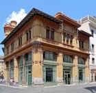
✴Palazzina Alterocca (1901-3), is on the right. This distinctive palace was designed by Cesare Bazzani for Virgilio Alterocca (see above). The ground floor of the palace was used for his commercial activities while the upper floor was his family home. It passed to its current owners, the Monte dei Paschi di Siena, in 1953.
-
✴The excellent Libreria Alterocca is diagonally opposite.
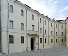
Turn left along Via Francesco Mancini and left again along Via Giordano Bruni, past the long facades of two palaces on the right that formed part of a complex known as the ex-Palazzo di Sanità:
-
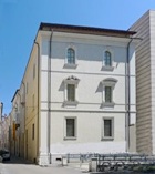
✴Palazzo Primavera, which is now used for exhibitions; and
-
✴what is now the headquarters of the Provincial Government.


Walk around this palace, into Piazza della Repubblica, where the walk ends.