Key to Umbria: Perugia
 

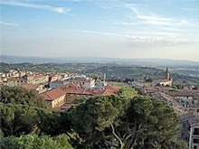
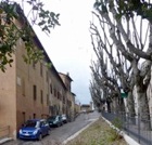
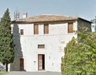
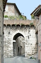
Rione di Porta Eburnea
Much of this area was destroyed in ca. 1540
to make way for Rocca Paolina (see below)

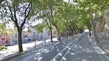
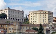
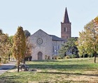
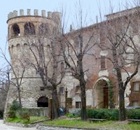
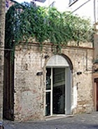
The church of Santa Giuliana is to the right in this photograph

Leave Piazza IV Novembre along Corso Vannucci and continue to Piazza della Repubblica (described in Walk I).   

Continue along Corso Vannucci, past:
  1. Palazzo Patrizi, which is now the Hotel Locanda della Posta, at number 89-101;

  2. the Baroque Palazzo Montesperelli (17th century) at number 103-7; and
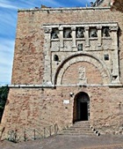
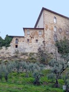
  3. the important Donini palaces opposite, with the church of Santa Maria del Riscatto on the narrow site between them (illustrated here).


The inscription on the side wall of Palazzo Antinori on the right (occupied on the ground floor by a shoe store) records that Orazio Antinori was born here in 1811.  He made his name as an explorer in Africa, where he died in 1882, aged 71.  His collection of artefacts from Africa is exhibited in the Museo Archeologico.
Continue into Piazza d’ Italia, past Palazzo Ansidei (now the Rosetta Hotel) on the right.


Walk across the façade of Palazzo Donini to the point at which Via della Forte enters the piazza.  This road (behind you in this photograph) , which was originally the Via Regale di San Pietro or dei Sellari (of the sadlers), was one of the main arteries of the city.  It acquired its present name in 1542, after the construction of Rocca Paolina (below), and was reduced to its current form during the rebuilding of the area after the demolition of this fortress after 1860.   Via della Forte was cut short here in ca. 1870, when Piazza d’ Italia was laid out in its current form in front of the Palazzo della Provincia (which, as described below,  replaced Rocca Paolina). 

The next part of the walk is slightly complicated because it explores the area at three different times:

  1. before the construction of Rocca Paolina;

  2. after its construction, which involved the destruction of some 200 houses, ten or more churches, a college and two nunneries; and

  3. after its demolition in 1860, when the area was redeveloped.

Before Rocca Paolina

This was the Baglioni quarter of Perugia from at least the 15th century, and it bristled with the towers of their palaces.  These stood on Colle Landone, and the walk towards them along Via dei Sellari would have been much steeper than it is now.  This detail of a fresco (15th century) by Benedetto Bonfigli in the Cappella dei Priori (now part of the Galleria Nazionale) gives an impression of the appearance of the Baglioni palaces.  They were raised to the ground after the Salt War (1540), and the area was levelled to create a platform for Rocca Paolina (below).  This walk takes in the vestiges of them that have been excavated under Palazzo dell Provincia.

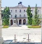
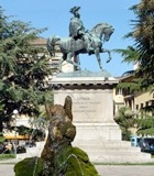
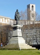
Follow the original line of Via dei Sellari to the statue of King Vittorio Emanuele II (below) that now stands at the centre of Piazza d’ Italia.   Two buildings here were demolished to make way for the fortress:

  1. the ancient church of San Silvestro, which was believed to have stood on the site of the house of St Herculanus; and

  2. the Albergo di San Marco, which stood on the opposite side of the road.
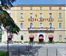
Continue diagonally to the right and along the right side of Palazzo della Provincia.  Piazza Santa Maria dei Servi was on your right.  This was site of two important buildings that were demolished in ca. 1540:
  1. Santa Maria dei Servi, which stood on what is now the site of Hotel Brufani (the ochre building on the right, described below), with its apse against the Etruscan city wall; and

  2. the college known as the Sapienza Nuova.


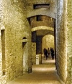
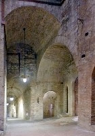
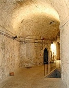
Walk along the loggia of the palace and take the escalator down.  This leads to the site of a road junction in the Baglioni quarter, which was of course, originally open to the sky:

  1. the excavated Via Bagliona to the left passed a number of Baglioni palaces and continued to Porta Marzia (below) 

  2. the unexcavated road to the right led past the ancient parish church of San Paolo to Piazza Santa Maria dei Servi.


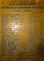
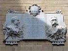
Turn left along Via Bagliona.  The door in the opening immediately on the left leads to space used by the Centro Espositivo della Rocca Paolina (CERP) for exhibitions.  The monument (1984) to the right of the door, which is by Romeo Mancini, commemorates  22 Perugian victims of the Fascist executions of 1921-2: the list to the right of the sculpture records their names and gives for each of them the place and date of the execution. 

The next opening on the left left gives a view of a room of the palace of Malatesta Baglioni, which contains the remains of a terracotta sink (15th century).


Two roads beyond to the right led to Porto Soccorso (see below): the one on the right allowed direct passage while the one to the right could be used in emergencies.


The huge statue (1980) of "Il Grande Nero" in the next opening to the right is by Alberto Burri, who gave it to the city in 1984.  The upper, semi-circular section rotates very slowly, so that the woman’s face on it is rarely visible.

The escalator beyond this point, which was opened in 1983, leads along the line of the old fortified corridor from the fortress to the southern stronghold (described below) to what is now Piazza dei Partigiani (below).  

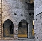
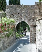
Return to and continue along Via Bagliona to the Trivio (junction): before the fortress was built, Via dei Sellari (above) continued to this point, following a line across what is now is now Piazza d’ Italia.  Take a short detour by turning left along the excavated stretch of it, past the remains of:
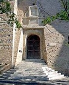
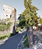
  1. the palace of Braccio and Ridolfo Baglioni on the left (illustrated here); and
  2. that of Gentile Baglioni on the right. 

Continue to the point at which the  the excavation of Via dei Sellari ended.  The road to your right just before this point led to the upper church of Sant’ Ercolano (described in Walk IV).
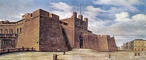

Return to the Trivio and continue along Via Bagliona.  The next opening on the left leads to the museum, which contains a number of interesting exhibits that relate to the history of Colle Landone and of Rocca Paolina.  [This museum was closed for restoration at the timee of my visit in 2013].  The room to the left of the museum entrance contains the remains of a Roman cistern that seems to have been re-used in the Middle Ages. 


Continue past one of the towers of the house of Gentile Baglioni on the left.  There was a gate here that could be closed when necessary, since Porta Marzia beyond it could not be. 


The Etruscan travertine abutments of Porta Marzia can be seen ahead, about 4 meters before the present exit to the complex.  Porta Marzia itself was demolished in 1542.  (This gate is also described in Walk II).


Rocca Paolina


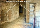
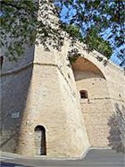
Look back as you leave the complex at the remains of the curtain wall of Rocca Paolina.  The components of the upper part of Porta Marzia were fortunately preserved and incorporated into this wall.   The arms of Pope Paul III and the inscription “PP III” that were inserted below them were subsequently  defaced, probably in 1798.

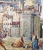
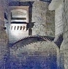
The next part of the walk follows the perimeter of the fortress.  Very little of the original structure survives, but it is recorded in the series of paintings (19th century) by Giuseppe Rossi reproduced below.  These paintings, which are now in the Galleria Nazionale, show the complex after the moat was filled (in ca. 1800) but before a large part of the fortress itself was demolished (in ca. 1860).    


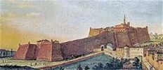
                        View of the fortress, the southern stronghold         Original point of departure

                                and connecting corridor, from the east                        of the corridor  

Continue down hill along Via Marzia, with the remains of the fortress wall on your right.  As described in more detail in Walk II, this road was built in 1810, after the moat here had been filled in.  Continue to the junction with Viale Indipendenza.  The spur in the wall at this junction (illustrated above) marks the point at which the fortified corridor linking the main part of the fortress to the southern stronghold began. 

All trace of the corridor and southern stronghold was destroyed after 1860, but they are recorded in the first two paintings by Giuseppe Rossi reproduced here (one above and one below).  From 1543 until 1831, this corridor completely separated Borgo Porta Eburnea on the left from Borgo Porta San Pietro on the right.  In 1831, an arch was opened in it so that the road to your right (now part of Viale Indipendenza) could be built.  This arch can be seen in the first of the paintings by Giuseppe Rossi (reproduced above). 


                               View of the corridor and Porta del Rastello               Porta del Soccorso

Turn right along Viale Indipendenza, with the remains of the wall of the main part of the fortress still on your right, to Porta del Soccorso, an emergency exit from the main part of the fortress.   Again, the papal insignia has been destroyed.   This second painting by Giuseppe Rossi (above) shows the view towards this point from the south west.  A gate known as Porta del Rastello to the left of the corridor was in line with Porta del Soccorso behind.


The curtain wall beyond Porta del Soccorso does not survive, but it can be seen on the right in this third painting by Giuseppe Rossi.  The painting also shows the stadium in front of it, which Cardinal Agostino Rivarola built century beside the fortified corridor in 1805-8 as part of a series of modifications designed to make Rocca Paolina more acceptable to the Perugians.  This stadium was used for “gioco del pallone”, a ball game then much in vogue, and for other spectacles, including bull fights.  Part of this structure stood in what is now Via del Circo, below and to the left of Viale Indipendenza (to the left in this photograph, in which Porta del Soccorso is visible at the extreme right).

Cross Viale Indipendenza into Via del Circo and look back towards Porta del Soccorso.   The steps to your right (at the end of the white line in the photograph) lead to the escalator down to Piazza dei Partigiani (below). 


Take a short detour down  these steps and continue down the steps beside the escalator to see the excavated remains of a retaining wall of the stadium on your right. 


Return to Via del Circo.   The church of SS Savino e Cataldo stands at the start of Via Torcoletti, which runs along the right side of Hotel Rosalba.  (The street takes its name from the small cakes baked by the nuns of the Monastero delle Bartolelle  - see below). 


Return to Via del Circo and continue uphill along Viale Indipendenza.  The ex- Sapienza Bartolina is immediately on the left (at 2 Via Fatebenefratelli ).  This building is now known as Casa Moretti-Caselli and houses an important stained glass museum and studio. 


Continue to the Torre dei Donati on the left (just visible at the end of the line of trees in the photograph above) and then round the hairpin bend of Viale Indipendenza: the stretch of the Etruscan wall that ran along the line of this road from Torre dei Donati was destroyed in 1540-3 to facilitate the construction of Rocca Paolina .  The side door of the venerable Hotel Brufani (described below) on the left stands on the site of Santa Maria dei Servi (see above), the apse of which probably extended over these walls.  


Until 1870, the terrace beyond Hotel Brufani did not exist: after the moat of Rocca Paolina was filled in in ca. 1800, the wide leafy Via dell’ Alberata was built on the left here, along the west side of the Rocca.  This fourth painting by Giuseppe Rossi shows its final stretch as it approached what was then Piazza Rivarola (now Piazza d’ Italia).   Palazzo Ansidei (see above) is visible at the end of the row of trees. 
Continue along Viale Indipendenza to the viewing point on the right, which is directly above the point at which the corridor joined the main part of the fortress.  This view inspired the Perugian poet and Nobel laureate Giosue Carducci to write his “Canto dell’ Amore” (Song of Love) in 1877. 


Cross Viale Indipendenza and take the steps up to the garden that was established in 1873 behind Palazzo della Provincia (below) as part of the urban redevelopment described below.  When Giosue Carducci died in 1907, these gardens were named for him.  A statue (illustrated here) depicts him still gazing at the view that had inspired him.  Other statues of famous Perugians here includes a more imposing monument (1923) to Perugino (behind and to the right of that of Giosue Carducci).


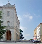
Continue round Palazzo della Provincia and look back on its main façade from Piazza d’ Italia. 


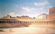
This fifth painting by Giuseppe Rossi shows the area after Cardinal Rivarola filled in the moat on front of the fortress to establish an elliptical space that was then called Piazza Rivarola.  The main façade of Palazzo Ansidei (above) can be seen to the right.

After Rocca Paolina

Marchese Gioacchino Napoleone Pepoli, who served as the Commissario Generale Straordinario delle Provincie dell’ Umbria after the liberation of Perugia in 1860, signed a decree (15th October) that gave the Rocca Paolina to the city.  The city authorities duly authorised its demolition on 17th December. 

The old Piazza Rivarola was renamed in honour of King Victor Emmanuel II  in 1861.  His statue by Giulio Tadolini was erected at its centre in 1890, twelve years after his death, in the presence of his son, King Umberto I.  The piazza was re-named as Piazza d’ Italia in honour of the newly-proclaimed Italian Republic in 1946.


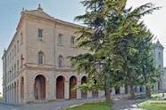
Alessandro Arienti, who was appointed as the chief engineer of Perugia in 1865, prepared the redevelopment plan for the entire area over the period 1866-83.  The construction of the Palazzo della Provincia (1869-72) was at the heart of it. 


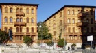
              Palazzo Calderini (from behind,               Palazzo Cesaroni                         Hotel Brufani

        with Palazzo della Provincia to the left)

Proceeding anti-clockwise, the other important buildings established here at around this time include:

  1. the semi-circular Palazzo Calderini (1871), to the left of Palazzo della Provincia, which followed the curve of the elliptical piazza;

  2. Palazzo Cesaroni (1897),  which was built in line with Palazzo Donini (above) on the side of the piazza opposite Palazzo della Provincia; and

  3. two structures that were built on the terrace established along the right side of Palazzo della Provincia , replacing Via dell’ Alberata (mentioned above):

  4. the Banca d’ Italia (1871), designed by Guglielmo Rossi; and
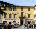
  5. Hotel Brufani (1881), designed by Alessandro Arienti for Giacomo Brufani when his original hotel (later Palazzo Gnoni-Mavarelli - see below) proved to be inadequate.

Leave Piazza d' Italia by Via Marzia, which runs to the left of and then behind and below Palazzo Calderini.   The fountain (1597) on the right was incorporated in the sustaining wall under Palazzo Calderini in ca. 1808.  The inscription on the fountain in the wall opposite the church records that Cardinal Lorenzo Lomellini, who was “more father than [papal] governor” of Perugia, restored it in 1682, when it was consequently named for him (as  Fonte Lomellina).  Its basin was destroyed in the Second World War, and subsequently replaced by the present shell-shaped travertine structure.


The top of church of Sant’ Ercolano (visited in Walk II) is opposite the fountain.  This was originally a double church, but the upper church was demolished when the fortress was built to clear the line of sight of its canons.


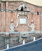
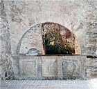
The inscription on the fountain also explains that the earlier road here was “too narrow, too sharp in its descent and too tortuous”, so Cardinal Lomellini made it “wider, gentler in its descent, straighter and more noble ... for the convenience of the citizens who, as a sign of their gratitude, call it Via Lomellina”.   This new road might have had a gentler slope than its predecessor, but it nevertheless descended steeply, in a straight line continuing that of the ochre buildings behind you (seen in the photograph above).  In 1830, after the moat of Rocca Paolina had been filled in, the present Via Marzia replaced it, secured by the retaining wall on the left: this new road curved to the right, allowing a gentler descent.  

Continue past Porta Marzia (above) to Viale Indipendenza, to revisit the spur of the fortress wall that marks the point at which the corridor to the southern stronghold began.  The walk now follows the line of this corridor.


Cross the main road and take the steps down to cut across the first hairpin of what has become Via Masi.  The road is named for Luigi Masi, the leader of the volunteer corps known as the Cacciatori del Tevere, who liberated Perugia in 1860.  Bishop Napoleone  Comitoli built Porta San Carlo (1612) at a site close to the foot of the steps here in 1612, in honour of St Charles Borromeo, some of whose relics he translated to Sant’ Ercolano at this time.  The gate was demolished in 1857.


Continue down the next flight of steps to the fountain (1992): the inscription reads “Perugia ai caduti di tutte le guerre” (from Perugia to all those fallen in war). 
  1. The back of Palazzo Gnoni-Mavarelli is on your left.  (You can usually enter through a door here to see the front of the palace).

  2. The back of what was the Caserma dei Carbinieri (1890), is in front of you: it now the Umbrian headquarters of Radiotelevisione Italiana.

Turn right along Via Fanti (which is named for Manfredo Fanti, the overall commander of the troops that liberated Perugia in 1860) and left along Via Masi.  This takes you along the front of the ex-Caserma dei Carbinieri.  The corridor joined the southern stronghold about half way along it.  Continue past the side of the twin Palazzine Biscarini and around in front of it (illustrated here).  Cross the road and look back at it from the terrace of Hotel Sangallo Palace: this was the southern-most extent of the stronghold. 
Continue to the roundabout in Largo Cacciatori delle Alpi, which is named for the volunteer battalion that Camillo Benso, Count of Cavour established under Giuseppe Garibaldi in 1859 to chase the Austrians from Italy.   The monument (1887) to Garibaldi at its centre, which was moved here in 1933 from Piazza Matteotti (see Walk II), marks the position of the south-east corner of the stronghold.  (The tower behind is the campanile of San Domenico, visited in Walk IV).


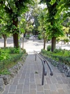
Continue round the curve of the road into the bus station in what is now Piazza Partignani.  This area, which was levelled after the demolition of the southern stronghold, was known as the Piazza d’ Armi and served as a huge parade ground and weekly livestock market.  In 1911, two early aeroplanes managed to take off from here and land in Foligno.  During the Second World War, the space was cultivated to provide food for the city.  This piazza, which received its current name after the war in honour of the anti-fascist partisans of Perugia, is connected to Piazza d’ Italia by the escalator from the excavated area under Palazzo della Provincia (above). 
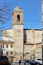
Continue into Parco Santa Giuliana, the church and ex-nunnery of Santa Giuliana ahead to the right.  The nunnery was scheduled for demolition as part of the original plan for Rocca Paolina, but was reprieved when the size of the planned southern stronghold was reduced.   The stadium to the left was built in 1938 and was the home of Perugia’s football team until 1975.  

Porta Eburnea 

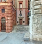
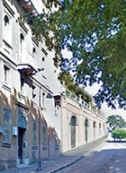
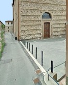
Return to the bus station, take the steps to the left up to Via Masi and continue uphill.  Turn turn left long Via del Parione (signed to Santo Spirito - see below).  This street runs between the walls of two old prisons: the Istituto di Pena Femminile (women’s prison) on the right; and the Istituto di Pena Maschile (men’s prison) on the left:

  1. This photograph shows the view along Via Torcoletti from its junction on the right of Via del Parione.  The entrance to the women’s prison is on the left of it.
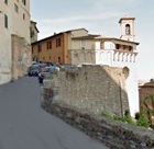


  1. This photograph shows the view back along Via del Parione, with the back wall of women’s prison on the left (in Via del Giardino - see below) and the men’s prison on the right.


These prisons were built in ca. 1870 to take both criminals (who had previously been incarcerated in Palazzo dei Priori) and political prisoners (who had previously been held in Rocca Paolina). 

  1. The last execution by decapitation in Italy took place outside the men’s prison in 1874.
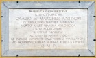
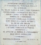
  2. The women’s prison was notorious in the Fascist period.  The inscription on its back wall (cut off at the left in the photograph above) commemorates the female victims of the Tribunale Speciale who were imprisoned here during the Fascist government. 


The prisons remained in use until the late 20th century, when the prisoners were moved to the Carcere di Capanne.

The monuments that were demolished to make way for these prisons included:

  1. two nunneries:

  2. the Monastero delle Bartolelle; and

  3. Santa Maria Maddalena delle Convertite; and

  4. the church of San Nicolò, which had subsequently been re-dedicated as San Giorgio dei Tessitori.

Take a short detour along Via del Giardino, which runs along the back wall of the women’s prison (see above).  Continue to Piazza di San Giovanni di Dio on the right and the church of San Giovanni di Dio.  This church belonged to the adjacent hospital of San Nicolò degli Incurabili.  The entrance to the left of the church leads to the part of the complex that has recently been adapted to house exhibitions: the inscription to the right of it records the alternative name of the hospital: “OSPEDALE FATE BENE FRATELLI”.


Return to the junction with Via del Parione and turn right to continue along it to the church and ex-convent of Santo Spirito.  Walk along the left side of the church to its façade in Piazzetta del Parione. 


On leaving the church, turn cross the piazza and left down the stepped Via degli Orti (visible at the lower right in this photograph).


Turn left at the bottom and walk through Porta Eburnea.  You can take a short detour by turning left along Viale Fiorenzo di Lorenzo to see the other side of the men’s prison.


Return to Porta Eburnea and continue along what is now Viale Pellini, which is named for the historian Pompeo Pellini (died 1594).  Torre dei Vicarelli (15th century), a circular bastion in the walls on the right, is similar in form to the tower incorporated into Palazzo della Penna. 


Continue to the junction with Via Don Giovanni Bosco on the left and the complex of the Istituto Don Bosco.  There is an impressive modern bust here of St John Bosco (died 1888), the founder of the Salesian Society.   (If you are taking the detour to the interesting church of San Prospero described below, you can ring the bell here to see if you the church can be opened for you.  It is usually open in any case for Mass at noon on Sundays). 


Parco della Cupa is on the other side of the road.  You can see the stretch of Etruscan walls here that forms the foundations of the buildings in Piazza Annibale Mariotti above (see Walk II). 


A short detour to San Prospero starts here.


Steps on the left of Viale Pellini just beyond the Istituto Don Bosco lead down to Via San Prospero.  This road passes between the ruins of two towers (probably 14th century) that may have formed a double gate with Porta San Giacomo (see below). 


San Prospero is on the left, behind the iron gates of the Salesian complex.  (There is a bell on the gate at the entrance).


Return to the Istituto Don Bosco, where the detour ends.


Cross the Viale Pellini and continue straight ahead through Porta San Giacomo.


Continue along Via della Forza to the junction with four other roads:
  1. Via Paradiso on the left;

  2. Via San Giacomo ahead;

  3. Via Eburnea (which leads to Porta Eburnea - see above) on the right; and

  4. Via degli Apostoli to the right of Via Eburnea, which seems to have been named for the Monastero degli Apostoli.  The “Apostoli” were a community of lay penitents (also known as Fraticelli) who built a small monastery on land in this area that was donated to them in 1391.  The complex was documented again in 1528, when the Commune gave it to the nuns of Sant’ Antonio da Padova.  Nothing else is known about it, but the name of the street suggests that it was close by. 

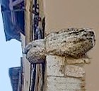
A large fish (very damaged) carved in the round has been inserted in the wall at the right-hand corner of Via Eburnea and Via San Giacomo. 
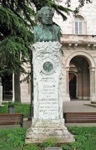
The ex-church of San Giacomo is slightly further along Via San Giacomo, on the right at number 50.


Retrace your steps to the junction and turn right up the steps of Via Paradiso to the Etruscan Porta della Mandorla (described in Walk II).  Walk through the gate along Via Bruschi. 


The house at number 18 on the right has a relief of a fish inserted into its façade, to the right of the door.


An inscription with impressive portraits at number 15 commemorates the residence here of the men for whom the street is now named:
  1. the artist Domenico Bruschi (1840-1910); and

  2. his father Carlo Bruschi, who was a prominent statesman during the liberation of Perugia from papal control in 1859-60.

Turn right along Via Cesare Caporali (named for the 16th century poet Cesare Caporali), which runs along the right wall of the church of Sant’ Angelo in Porta Eburnea.  (You need to turn left at the junction and then look back to see its ancient campanile, above the apse).


Continue along Via Cesare Caporali.  Take a short detour by turning right along Via del Pozzo.  The house at number 8 on the left belonged to the mathematician Giuseppe Neri: the inscription on its facade records that Neri hosted Galileo Galilei here in 1618 and that “they studied together the great problems of the universe”. 

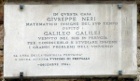
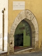
Return to Via Cesare Caporali.  An Etruscan well (3rd century BC) that was discovered here cannot be visited.  Its construction is apparently similar to the more famous Pozzo Etrusco in Piazza Danti, and it is interesting to note that both were sunk just inside the walls of the Etruscan city. 

Continue to the junction with Via Bonazzi, which is named for the historian Luigi Bonazzi (died 1879).  A right turn here would have led directly into Piazza dei Servi until 1540, when this piazza was destroyed to make way for Rocca Paolina.  Remains from the mostly-demolished convent of Santa Maria dei Servi can be seen  in the walls on the right of Via Cesare Caporali, just before the junction: this part of the convent provided accommodation for the students of the Sapienze Nuova after its own premises in Piazza dei Servi were also demolished. 


Turn left along Via Bonazzi, passing on the right the steps of Via Grecchi on the right.  This street is named for Mario Grecchi, who was severely wounded near Perugia in 1944, when he was still only 18, while leading a company of partisans against a German battalion.  He was severely wounded but kept alive long enough to face death by firing squad.


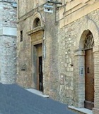
                              ex-Oratorio dei Santi Crispino e Crispiniano                  ex-Chiesa del Suffragio

There are two interesting buildings on the left:

  1. the ex-Oratorio dei Santi Crispino e Crispiniano at number 41; and
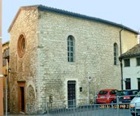
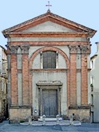
  2. the ex-Chiesa del Suffragio at number 37.

The remains of the ex-church of SS Stefano e Biagio are incorporated into a shop façade at number 10 on the right.


Via Larga is ahead on the left.  In 1785,  Ugiccione di Sorbello gave his palace here [which building?] to the Eugeni family in 1785 in exchange for Palazzo Sorbello.

Continue to the end of Via Bonazzi into Piazza della Repubblica and return along Corso Vannucci into Piazza IV Novembre, where the walk ends.


Return to Walks in Perugia.
Home.htmlshapeimage_2_link_0


Perugia - Walk VII

From Piazza IV Novembre to Rocca Paolina and Santa Giuliana


Umbria:  Home   Cities    History    Art    Hagiography    Contact 


Perugia:  Home    History   Art    Saints    Walks    Monuments    Museums