
The development of suburbs outside the Etruscan walls of Perugia began in the 12th century, as people moved here from the surrounding countryside. The first of these suburbs, which developed outside Porta Marzia and Arco di Sant' Ercolano, towards the Abbazia di San Pietro, was documented in 1152. It seems likely that an intermediate circuit of walls that included a gate on the site of the present Porta San Pietro had been built by 1199. (This gate, which retained its ceremonial importance even after new walls were built around the extended suburb, has its own page in this website).
The suburbs were the natural constituencies of a class of rich merchants known as the popolani, who economic and political interests differed from those of the nobles who were established within the Etruscan walls. This led to factional strife on a number of occasions. The terms of an arbitration process between the factions carried out for Pope Honorius III by Cardinal John Colonna required (inter alia) that the popolani should dismantle the walls and ditches that they had constructed on land that belonged to the nobles, whom they had previously driven from the city. This throws light on the sporadic way in which the suburbs came to be enclosed within a new circuit of walls.
The list of city gates in the outer walls published in 1273 suggests that the process of enclosing the suburbs had been largely completed in the previous 50 years. The main gates (using their current names) in the list were:
-
✴in rione di Porta San Pietro (where suburban development had extended beyond Porta San Pietro):
-
•Porta di Braccio, which is now stranded in the grounds of the Abbazia di San Pietro; and
-
•Porta di San Girolamo;
-
✴in rione di Porta Sole:
-
•Porta di Sant’ Antonio; and
-
•a gate near San Bevignate in a wall that no longer exists around the suburb of Fontenuova;
-
✴in rione di Porta Sant’ Angelo:
-
•Porta Bulagaio; and
-
•Porta San Cristoforo (which was close to the mid point of what is now Corso Garibaldi):
-
✴in rione di Porta Santa Susanna:
-
•Porta Santa Mustiola, the location of which is unclear; and
-
•Porta Santa Susanna; and
-
✴in rione di Porta Eburnea:
-
•Porta San Giacomo.
The inner (Etruscan) walls still divided the city centre from its suburbs and its gates were locked at night until 1276, when the authorities finally agreed to demands from the popolani that they should be left open. At this point, the gates in the outer (medieval) walls became the gates of the city itself.
In 1295, the vie regali (main roads from that radiated outwards from the city centre) were specified in terms of their points of exit from the city:
-
✴in rione di Porta San Pietro, from Porta di Braccio;
-
✴in rione di Porta Sole, from Porta del Carmine and then through the suburb of Fontenuova;
-
✴in rione di Porta Sant’ Angelo, from the gate beyond the crossroads at Sant’ Angelo (which seems to have been an ante-porte);
-
✴in rione di Porta Santa Susanna, from Porta Santa Susanna; and
-
✴in rione di Porta Eburnea, from Porta San Giacomo.
-
Two intermediate gates were mentioned, each of which was designated as “portam civitas que vocatur ...” (the city gate which is called ...). These were almost certainly gates in the inner Etruscan walls, and were presumably named in order to distinguish them from other nearby gates in these walls. These two intermediate gates were:
-
•in rione di Porta San Pietro, “Porta Sancti Petri”, a designation that probably distinguished Porta Marzia from the less important Arco di Sant’ Ercolano; and
-
•in rione di Porta Sole, “Porta Solis”, a designation that probably distinguished the now-demolished Arco della Piaggia dei Calderari and Arco dei Gigli (either of which could have been Porta Sole).
The rione di Porta Sant’ Angelo was still expanding along what is now Corso Garibaldi in 1295. This suburb did not receive its present outer wall (which includes Porta Sant’ Angelo) until 1327-42. This took the length of the outer walls to some 6 km, about twice the length of the inner Etruscan circuit.
Walk III
Porta Santa Susanna (13th century)
The original Porta Santa Susanna, which gave its name to the rione di Porta Santa Susanna from at least 1073, was probably the gate in the ancient walls that is now known as Porta Trasimena. The suburb that developed outside Porta Trasimena had probably been enclosed by walls by 1273, when a gate on the site of the present Porta Santa Susanna was documented. This gate, which was the only important gate in the medieval walls around this suburb, had taken over its present name by 1295, when it constituted one of the two main entrances to the city from Orvieto and Lake Trasimeno. The gate was also known as Porta della Colombata, for the ex-nunnery of Santa Maria della Colombata, outside the walls here.
The upper part of the gate on the outside (on the right, above) is a later addition, and is decorated with a relief of a griffin.
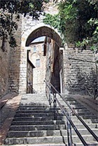
Arco di Via Appia (1257-77)
Porta Vecchia della Conca (13th century)
The gate was walled up at some point and re-opened only in 1931.
Porta Elce di Sopra and Porta Elce di Sotto (14th century)

Porta Elce di Sopra Porta Elce di Sotto
A new stretch of walls that was built in 1327-42 from Porta Vecchia della Conca to Porta Sant’ Angelo (see Walk V below) to enclose the parish of Sant’ Elisabetta, which had grown up in what had been the rural area of the Conca. (This was the last new parish to be established in Perugia in the middle ages: the population growth evident up to that point ended with the plague of 1348).
Two gates were built in the section of walls that were built around the depression known as the Conca, to. The foundation of this section of the wall was laid in 1327, and the wall itself was built in 1338-42.
-
✴Porta Elce di Sopra was closed in the 19th century and re-opened in 1931.
-
✴Porta Elce di Sotto (also called Porta Nuova della Conca) was modified in the 19th century. The remains of the original entrances to the two side towers can be seen on the inside of the gate.
Walk IV
All of the gates in this walk are in the rione di Porta San Pietro.
-
✴The original Porta San Pietro, which gave its name to this administrative region from at least 1070, was probably the gate in the ancient walls that is now known as Porta Marzia.
-
✴The suburb that developed outside it initially had a circuit of walls that seems to have had at least three gates by the end of the 12th century:
-
•Porta dei Funari, to the west;
-
•the present Porta San Pietro, which has its own page in this website; and
-
•Porta Santo Stefano, which was presumably near Santo Stefano (later the site of San Domenico) to the east, but which no longer exists.
-
Porta San Pietro, which was by far the most important of these gates, stood at the point at which the road from Perugia branched into two:
-
•the road to left (the present Via Bonfigli) led to Assisi and Rome; and
-
•the road ahead passed the Abbazia di San Pietro and continued along the old Via Amerina to Todi and Rome.
-
✴Two gates were documented in 1273:
-
•The “porta del borgo di San Pietro, insta quam est via qua itur versus Sanctam Trinitatem” (the gate of the suburb of Porta San Pietro, at the start of the road that leads to SS Trinità) probably stood on the site of the late Porta San Girolamo.
-
•The other gate “near the Abbazia di San Pietro, above San Constanzo” was the gate that is now stranded in the grounds of the abbey. It became known as the Porta di Braccio when Braccio Fortebracci restored it in 1421.
-
This suggests that the wall around the rione di San Pietro had almost reached its current extent by 1273:
-
•The eastern stretch of this wall stood above the deep depression of the fosso (ditch) di Santa Margherita and incorporated the wall around the Abbazia di San Pietro.
-
•Its western stretch stood on more level ground, and contained no gates (apart from the existing Porta dei Funari) because they would have been difficult to defend.
-
✴In ca. 1420, Braccio Fortebracci built an outer wall from Borgo San Pietro to Porta Eburnea to the west along the Fosso di Sant’ Anna, in order to reduce the risk from the south. This wall met the west wall of Borgo San Pietro at its approximate mid point, at a new gate, Porta dei Ghezzi, at right angles to it.
-
✴The present Porta San Costanzo replaced the Porta di Braccio in 1587, when the original road was diverted to the west for the convenience of the monks of the Abbazia di San Pietro.
-
✴The monumental gate known as Tre Archi was built in 1857 to replace Porta dei Funari, as part of a major road improvement scheme.
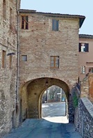
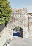
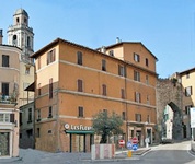
Porta dei Funari (12th century)
The gate was partially buried when the road level was raised in the 19th century and replaced by Tre Archi (below). It was subsequently walled up for a period and housed a public latrine.
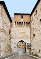
Porta San Girolamo (1582)
Cardinal Alessandro Riario rebuilt it again during the reign of Pope Gregory XIII. The empty niches to the sides of the inner arch (photographed here) originally housed statues of SS Peter and Paul.
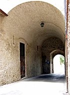
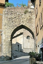
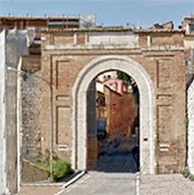
Porta di Braccio (13th century)
The gate was re-named in honour of Braccio Fortebracci in the early 15th century when it was incorporated into the new stretch of walls that reinforced the city’s defences. This part of the wall was demolished in 1587 when the road was diverted, but the gate and one of its two towers survives.
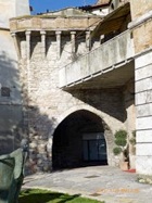
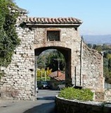
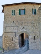
Porta dei Ghezzi (15th century)
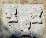
This gate takes its name from a relief of the heads of three “Ghezzi” (Arabians) on its outer facade, which was perhaps the symbol of a local family of that name. It belonged to the walls that Braccio Fortebracci built in ca. 1420 to reinforce the city’s defences (see also Porta di Braccio, above).
-
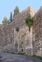
✴Substantial stretches of these walls survive to the right of the gate, extending towards Porta San Costanzo (below).
-
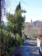
✴The walls also ran to the left of the gate (across Viale Roma) towards Santa Giuliana. (This photograph of the line of the walls to Santa Giuliana in the distance is taken from the entrance to the garden opposite the gate).
The gate became redundant when the Viale Roma was built. Its upper part was later incorporated into the complex of the Opere Pie Donini behind it: the gate itself has been restored as part of the restoration project for that complex.
Porta San Costanzo (1586-7)
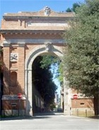
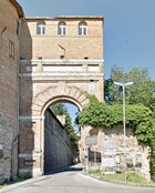
Tre Archi (1857)
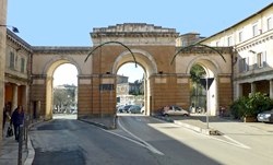
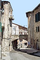
The monumental Tre Archi (three arches) was built in 1857, when Via Marconi was extended across Corso Cavour, along what had been the left wall of the church of Santa Croce. Vestiges of the cloister of Santa Croce survive to the sides.
This gate replaced Porta San Carlo (see Walk VII below) as the main entrance to the city from Tuscany.
For Porta di Braccio, return to the exterior of San Pietro.
For the other gates here, return to Walk IV.
Return to Monuments of Perugia.
Walk V
All of the gates in this walk are in the rione di Porta Sant’ Angelo.
-
✴The original Porta Sant’ Angelo, which gave its name to this administrative region from at least 1036, was probably the gate in the ancient walls that is now known as Arco Etrusco.
-
✴The suburb that developed outside it initially had a circuit of walls that seems to have had at least four gates:
-
•Porta Bulagaio (also known as Porta delle Voltole);
-
•Porta San Cristoforo;
-
•Porta dei Pasteni; and
-
•Porta Vecchia della Conca (see Walk III, above).
-
✴The present Porta Sant’ Angelo, which marks the final extent of the suburb, was first documented in 1295, when it was an ante-porte on the main road to Città di Castello.
-
✴The extension of the city walls in the early 14th century that included this gate, is attributed to Ambrogio Maitani. It seems to have occurred in three phases:
-
•from Porta Bulagaio around the Convento di Sant’ Agostino to Porta dello Sperandio (a gate that was built at an unknown date and restored in 1329);
-
•from Porta dello Sperandio to Porta Sant’ Angelo; and
-
•from Porta Sant’ Angelo around the depression known as la Conca to Porta Vecchia della Conca (in Walk III, above).
-
The foundations of this third section of the walls were laid in 1327, and the wall itself was built in 1338-42. It contained two gates (also in Walk III):
-
•Porta Elce di Sopra; and
-
•Porta Elce di Sotto (also called Porta Nuova della Conca).
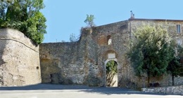
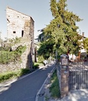
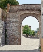
Porta Bulagaio (1764-5)
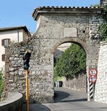
This gate stands on Via Bulagaio, which probably follows the line of an Etruscan road that began at the Arco Etrusco. The first gate on this road, which was slightly nearer the city, was documented as Porta delle Voltole in 1273.
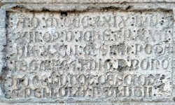
The inscription on the present gate records that it was built by the Collegio della Mercanzia during the terms of office of two priors in succession: Alessandro Vincioli (in 1764); and Giuseppe Coli (in 1765).
Porta San Cristoforo (13th century, now demolished)
This gate near the church of San Cristoforo in what is now Corso Garibaldi was documented in 1273, when the road between it and Arco Etrusco (then called Porta Sant’ Angelo) was paved. This gate and the adjacent walls were demolished in the 14th century because the suburb had by that time extended as far as the present Porta Sant' Angelo (see above). Vestiges of Porta San Cristoforo that survived in the 19th century have since disappeared.
Porta dei Pasteni (13th century)
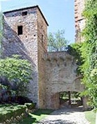
Porta dello Sperandio (early 14th century)
This arch formed part of the walls that were built around the rione di Porta Sant' Angelo in the early 14th century.
The inscription above the arch in the outer wall records that the “boni homines” Ludovico Crescioli and Pellolo Paolucci restored this gate in 1329. The reason for this restoration of the gate so soon after the construction of the walls here is unclear:
-
✴it might have been damaged in an earthquake; or
-
✴it might have pre-dated the walls, perhaps as part of an earlier defensive structure.
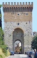
Porta Sant' Angelo (late 13th century)
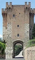
Outside walls Inside walls
This gate was documented:
-
✴in 1295 as “ultra crucem Sancti Angeli” (beyond the crossroads of Sant’ Angelo) on the main road to Città di Castello; and
-
✴in 1309 as “porta Herminiorum, que est ultra crucem Sancti Angeli”: the name of the gate is a reference to the Armenian monks who owned San Matteo degli Armeni, just outside it.
In 1326, the Commune commissioned Ambrogio Maitani to repair a “turrione vetus seu penna .... iusta portam muri veteris porte Sancti Angeli”. While some writers suggest that this refers to the present porta Sant’ Angelo, Ugolino Nicolini (referenced below) has shown that this document refers to a tower that belonged to the della Penna family near the ancient gate that is now called Arco Etrusco: this gate had given its name to the rione di Porta Sant’ Angelo, one of the five administrative districts of Perugia.
The present Porta Sant’ Angelo was an ante-porte until ca. 1327, when new walls were built to enclose the extended suburb. The work on this project, which might well have included the adaptation of the existing gate, is attributed to Ambrogio Maitani.
The gate was remodelled on a number of subsequent occasions:
-
✴The papal legate Gérard du Puy, Abbot of Marmoutier, (known to the Italians as “Monmaggiore”) re-fortified it in 1372.
-
✴Braccio Fortebracci commissioned Fioravante Fioravanti to restore it in 1424.
-
✴The upper fortification was added in 1479.
-
✴Austrian soldiers destroyed it in 1797, and it was effectively rebuilt in 1820.
-
✴The Fascist government of Perugia restored it in 1930.
The tower was used to monitor enemy aircraft in the Second World War, and belonged to the Partito Socialista (Socialist Party) in the 1950s.
In its present form, the tower above the gate has a square plan and is built in three storeys, each of which is in a different material (respectively stone, limestone and brick). These materials presumably belong to successive phases of adaptation. The present battlements were built in the restoration of 1930.
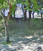
Stairs to the right (as you look at the gate from inside the city) lead to the ramparts, and to the Museo delle Porte e delle Mura Urbiche, a small museum that illustrates the history of the city walls of Perugia. (It has fantastic views).
Walk VI
All of the gates in this walk were in the medieval walls around the rione di Porta Sole.
Porta Santa Margherita (13th century)
The brick bastion to the right outside the walls formed part of the defensive structure that was put in place in 1516 when Duke Francesco Maria della Rovere of Urbino threatened Perugia. Much of this rest of this structure was destroyed in 1822 when Via XIV Settembre was built.
Porta del Carmine (13th century)
The gate was largely destroyed in 1822 when Via XIV Settembre was built outside it, and is now reduced to the role of entrance to the underpass by which pedestrians can cross this busy thoroughfare.
Arco dei Tei (13th century)
The arch seems to have been opened in the walls in the 13th century to provide access to the new Borgo Sant' Antonio. It was restored in 1794 at the expense of the Confraternita di San Benedetto, whose oratory is nearby.
Porta Pesa (13th century, now demolished)
Largo di Porta Pesa Customs Barrier (19th century)
The campanile of Santa Maria Nuova is on the left and Arco dei Tei (above) is on the right.
A second gate gate seems to have been opened in the 13th century in what is now Largo di Porta Pesa to provide access to the new Borgo Sant' Antonio. It was demolished in the 19th century and replaced for a period by a customs barrier, which can be seen in the photograph on the right above. The word "Pesa" refers to the weigh bridge here that was used to assess the duty payable on goods entering the city.
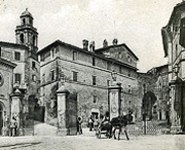
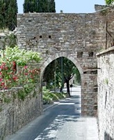
Porta Sant’ Antonio (13th century)
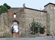
This gate named is named for the nearby church of Sant’ Antonio Abate. A gate was documented here in 1273 as the “porta qua itur ad Sanctum Benedictum” (gate that leads to San Benedetto (now Sant’ Erminio)) .
In 1374, papal legate Gérard du Puy, Abbot of Marmoutier, (known to the Italians as “Monmaggiore”) incorporated this gate into a new fortress, which had six towers and two drawbridges. This fortress was connected to Fortezza di Porta Sole by means of a fortified corridor that ran along the top of the city wall to the right (as you look at the gate from the outside). When the Perugians revolted and expelled the legate from the city in 1375, most of the new defensive structures were demolished, although the fortress at Porta Sant’ Antonio survived until 1424.
The Commune restored the gate to a design by Rocco di Tommaso da Vicenza in 1516, when Duke Francesco Maria della Rovere of Urbino threatened Perugia.
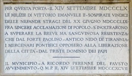
An inscription on the outer wall above the arch records that the people of Perugia acclaimed the militia of King Victor Emanuel II as it passed through this gate on 14th September, 1860, after the city’s recovery from the massacre of the 20th June 1859. The road from the gate into the city was renamed in 1871 as Corso Bersaglieri in honour of this regiment of Bersaglieri (light infantrymen), which was led by Enrico Cialdini.
Walk VII
This walk includes the two gates in the medieval walls around the rione di Porta Eburnea.
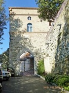
Porta San Giacomo (13th century)
Porta San Giacomo Remnants of arch
in Via San Prospero
This gate was documented in 1273 as Porta San Prospero, in reference to the church of San Prospero outside the walls. It might have formed part of a double gate, with a second arch in Via San Prospero, a little way to the south (illustrated in the photograph above, on the right). The gate was described in the document of 1273 as “porta qua itur ad locum fratrum Servorum Sancte Marie” (the gate that leads to the place of the Servite friars): these friars subsequently moved to Santa Maria dei Servi.
This gate was documented again as Porta San Prospero in 1295, However, the nearby Porta Eburnea Nuova (below) subsequently took over this role.
The gate on this site was subsequently more commonly named for the nearby church of San Giacomo inside the walls, or occasionally as Porta del Castellano and Porta dell’ Olmo.
The arch here was walled up in 1858, when it was in danger of collapse, and was re-opened in the early 20th century.
Porta Eburnea Nuova (13th century, rebuilt in 1576)
The first gate was probably opened in the medieval walls here in the late 13th century, probably to provide better access to the city for the merchants bringing fish from Lake Trasimeno. It seems that Braccio Fortebracci restored it in ca. 1423.
The inscription above the arch on the exterior wall records that the papal governor Ottavio Santacroce rebuilt the ruined structure in 1576. It became known as Porta Crucia at that time. Its design is attributed to Valentino Martelli.
The original Porta Eburnea, which gave its name to this administrative region from at least 1116, was in the ancient walls. The gate on this site Has been known as Porta Eburnea Nuova since the 19th century.
Porta San Carlo (1612)
The gate was at the bottom of the steps that cut across the first hairpin of Via Masi. Via Lomellina followed the line of these steps and continued in a steep ascent past the upper part of Sant’ Ercolano to Via Floramonti.