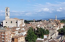
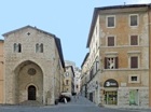
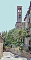
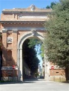
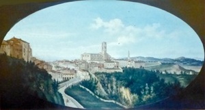
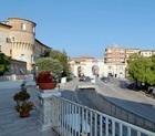
Rione di Porta San Pietro,
with San Domenico on the left and
the campanile of San Pietro in the distance on the right
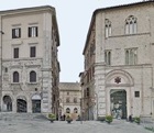
Leave Piazza IV Novembre along Via Calderini, which is named for the architect
Guglielmo Calderini (1837-1916). The papal legate Cardinal
Domenico Pinelli created this street in 1591 as a link between Piazza Grande and Piazza Sopramuro (now Piazza IV Novembre and Piazza Matteotti). This required the demolition of part of the ex-
Collegio dei Notai. The planning of this urban development is attributed to
Valentino Martelli.
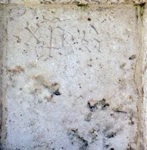
Inscriptions on the pilasters at the start of the street record the earlier name, Via Pinella, and (barely visible at the top in this photograph) the date 1591.
Continue into Piazza Matteotti (see Walk II). Turn right along Via Baglioni, which was originally a narrow street that led to the upper church of Sant’ Ercolano. It became more important after 1543 because it then led to Rocca Paolina. Cardinal Alessandro Riario widened and paved it in 1582, when it was renamed Via Riario. It received its current name in honour of the Baglioni family in 1871.
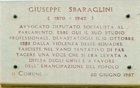
The plaque on the wall of number 4 records that the office here of the Socialist lawyer and politician
Giuseppe Sbaraglini was destroyed by Fascist thugs in 1922 in a vain effort to silence him.
The street contains a number of interesting palaces:
-
✴Palazzo Florenzi at number 1-7;
-
✴Palazzo Baglioni at number 14-30; and
-
✴three palaces described in the page on Other Patrician Palaces in Perugia:
-
•Palazzo Baldeschi Colonna at number 9;
-
•Palazzo Cesarei Rossi Leoni at number 11-15; and
-
•Palazzo Monaldi at number 17-29.
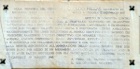
The plaque on the wall of Palazzo Monaldi commemorates the Perugian
Leopoldo Pellas , who died heroically in action during the retaking of Caposile in northern Italy from the Germans in 1918. The plaque records that he was motivated by hatred since his brother Demetrio had been killed by the Germans a year before. Such was his valor that the German forces dropped a note from an aeroplane informing the Italians that they had given him an honorable burial. He was awarded the Medaglia d’ Oro.
Turn left into Via Marzia. The headquarters of the
Sodalizio di San Martino is on the left, at the junction with Via Floramonti (where Via Marzia turns through 90 degrees to the right).
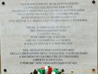
Turn left along Via Floramonti. The Fascist government used the house at number 10 as a prison. The plaque on its wall was placed here on 25th April 2005 to mark the 60th anniversary of liberation of Perugia from fascism. Those commemorated in it include:
-
✴Gastone Sozzi, a young anti-fascist from Cesena, who was imprisoned here and died during torture in 1927; and
-
✴Mario Santucci, who jumped from the window to bring an end to his torture. (He initially survived but died two years later).
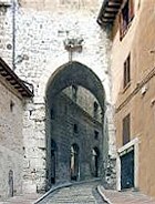
Turn sharp right at the end, down the stepped Via di Sant’ Ercolano and through Arco di Sant' Ercolano (visited in
Walk II), which seems to have been opened in the Etruscan walls in the 12th century. Continue past the church of Sant’ Ercolano on the right (also visited in
Walk II) to Corso Cavour.
Corso Cavour forms the spine of the Borgo Porta San Pietro, one of the suburbs that grew up outside the Etruscan city walls in the 13th century. This was the pilgrimage road to the Portiuncula (outside Assisi) and to Rome, and has probably been paved since Roman times. It was originally known as Via Regale and later as Via Papale, possibly when Perugia fell more firmly under papal control after the death of Braccio Fortebracci in 1424. Its current denomination in honour of Count Camillo Benso di Cavour dates to 1871.
-
✴A number of buildings on the right, at the start of this road, which included Palazzo Pontani, were demolished in 1836, in order to link it to what is now Viale Indipendenza.
-
✴The first building opposite (i.e. on the left) was the site of the hotel in which the American Edward Newton Perkins and his party were staying when papal forces stormed Perugia on 20th June 1859. The soldiers killed the owner of the hotel and two of his staff and robbed the terrified guests of their possessions. The letter of outrage that Edward Newton Perkins sent to “the Times” arguably contributed significantly to the political climate that facilitated the annexation of the Papal States to the new Kingdom of Italy in 1860.
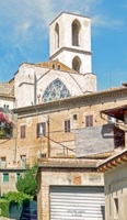
Continue along the side of the church of
Santa Croce to the junction with Via Marconi to the right and Via XIV Settembre to the left. (Santa Croce is on your right, but on the left of this photograph, which looks back towards Sant’ Ercolano). The area has suffered a series of major changes:
-
✴The church of San Claudio stood across Corso Cavour from Santa Croce until it was demolished in 1798.
-
✴Via Marconi was built along what had been the left wall of Santa Croce in 1857, and the entrance to the church was moved to this wall from Corso Cavour.
-
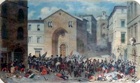
✴This watercolour (ca. 1860) in the
Museo dell' Accademia di Belle Arti, which is attributed alternatively
to Cesare Martinelli or Napoleone Verga, shows the arrival of papal forces here on 20th June, 1859, during the massacre following Perugia’s anti-papal rebellion.
-
-
✴The junction was blown up by the Germans before their departure from Perugia in 1944. Santa Croce survived, but all the other buildings here were destroyed.
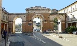
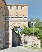
Take a short detour by turning right along Via Marconi as you leave Santa Croce. The monumental Tre Archi (three arches), the city gate ahead of you, was opened in 1857. Vestiges of the cloister of Santa Croce survive to the sides.
Return to and continue along Corso Cavour, past
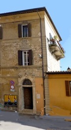
Palazzo Meniconi Bracceschi (late 17th century) at number 25 on the right. The
Énoné restaurant further along on the right (at number 61) housed the pharmacy owned by Sebastiano Bellucci in the 19th century. A plaque inside commemorates him, along with the other members of his family who died when their residence above the shop was struck by a cannon shot fired by the papal army on 20th June 1859.
The road opposite widens on the left into Piazza Giordano Bruno. The inscription on the wall of the first house on the left records that
Giordano Bruno was honoured (by the re-naming of the piazza) in 1907, in the place in which his executioners had operated: this is a reference to the nearby Palazzo dell’ Inquisitzione (see below). This commemoration was made in the anti-clerical period following the unification of Italy: Giordano Bruno had famously renounced the Dominican Order in 1576 and had been executed as a heretic in Rome in 1600.
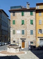
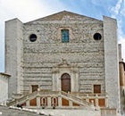
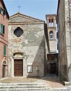
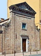
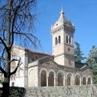
The piazza had previously been named for the huge church of
San Domenico on the right.
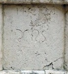
Latin inscription and date Greek inscription
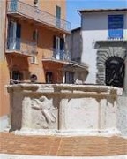
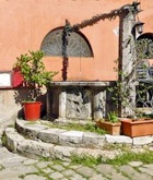
The well (1452) in front of the church contains reliefs of a griffin and a shell (the symbol of pilgrims en route to Santiago di Compostella) and inscriptions of the name of Christ in Latin and in Greek: the date is above the first of these inscriptions.
The entrance to the main cloister of the adjacent convent is to the left of the church. This leads to:
-
✴the remains of the facade of the Dominicans' earlier church, later known as San Domenico Vecchio;
-
✴the ex-Oratorio di San Domenico; and
-
✴the Museo Archeologico Nazionale, which now occupies most of the conventual buildings.
Leave Piazza Giordano Bruno by Via del Castellano, which runs along the right wall of San Domenico. The name of this street and that the church of San Stefano del Castellare, which was incorporated to form the right transept of San Domenico, suggests that this site was once heavily fortified.
Continue to the left, behind the apse of San Domenico to the ex-Palazzo dell’ Inquisitzione (1632), which formed part of the Convento di San Domenico. As recorded in the inscription mentioned above, the Dominican Order was prominent in the persecution of “heretics”. The fine portal of the palace, with its original wooden doors, bears the date 1667. The palace, which was restored in 1710, passed to the Commune in 1860, but returned to San Domenico in 1956. The part of the palace to the left has been restored for use by the friars.
Walk back past the apse of San Domenico and past an interesting well (15th century), with a relief of a rampant griffin (now part of Locanda Do Pazzi).
Take a short detour by turning back a little way along Corso Cavour to Via Giulia on the left. The house just beyond, at number 97 was the site of the nunnery of
Santa Maria delle Orfane.
Take a short detour by turning left along just beyond it, along Via Cantorino and though the gate. The building here that once housed the
Fornace Angeletti-Biscarini has two facades that were decorated with some of the architectural terracottas that were produced here in the 19th and early 20th centuries:
-
✴one is down the steps ahead of you, at number 16; and
-
✴the other, at number 22 (illustrated here), is further along Via Cantorino: go up the steps again and follow the road round to the left, along the garden hedge.
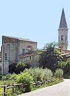
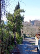
Via Cantorino offers lovely views of the campanile of two churches:
-
✴Santa Maria di Colle (ahead as you walk towards number 22); and
-
✴San Domenico, as you return.
Return to and continue along Corso Cavour.
Santa Maria Maddalena delle Repentute Monastero della Beata Colomba
There were two important nunneries on the right:
-
✴the ex-Monastero della Beata Colomba now serves as the fire station at number 127 on the right; and
-
✴the ex-nunnery of Santa Maria Maddalena delle Repentute was further along on the right, at number 133.
Take a short detour by retracing your steps along Corso Cavour and taking the first turning on the right (Via del Deposito):
-
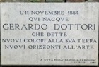
✴The plaque at number 11, to the left, commemorates the artist
Gerardo Dottori, who was born here.
-
✴The closed arch at the end on the right was originally the entrance to the oratory of the
Confraternita di San Pietro Apostolo. This confraternity, which had previously met in the Cappella di San Giacomo at Porta San Pietro (described below), moved to a new oratory here (in what was then an orchard next to Santa Maria di Colle) in 1579.
Retrace your steps and continue along Corso Cavour. There is an interesting image in the niche over the entrance to Via degli Archi (the next turning on the left), albeit that it is difficult to see. The original image, which is known as the
Madonna del Fuoco, was given this name when it miraculously survived a fire in Forli in 1428. Father
Marcello Tartini, the rector of the Collegio di Santa Anna, brought this copy of it to Perugia, and it was initially kept in the church of
Santa Maria del Popolo. The Confraternita del Sacramento, which met in Santa Maria di Colle (above), received permission to move it to its present location in 1777. It is in poor condition, despite its recent restoration.
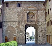
Inner side of Porta San Pietro Outer side of Porta San Pietro
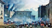
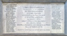
The road ahead, Borgo XX Guigno, is named for the disastrous events of 20th June 1859, when Swiss guards of the papal army massacred Perugian supporters of the Risorgimento here.
-
✴This watercolour (ca. 1860) in the Museo dell' Accademia di Belle Arti, which is attributed alternatively to Cesare Martinelli or Napoleone Verga, shows the arrival of papal forces at Porta San Pietro (to the right).
-
✴The inscription on the inner arch of Porta San Pietro (visible from outside the gate) commemorates the Perugian patriots who died or were injured during these events.
Borgo XX Guigno continues through what was, in the early 15th century, a pleasant suburb outside the city walls. In order to strengthen the city’s defences, Braccio Fortebracci enclosed the area in an outer loop of walls in the early 15th century, incorporating the walls of the Abbazia di San Pietro (see below) at its southern point.
Walk along Borgo XX Giugno to the ex-Oratorio di Sant' Anna at number 43 on the right, which, together with the buildings to the right of it, once belonged to the
Conservatorio delle Derelitte. The crumbling inscription on the facade of number 45 records a bequest by the Contessa
Laura Donini Montesperelli (in 1854). The complex, which became known as the Opere Pie Donini, was consequently extended into the adjacent Via Ghezzi (to the right).
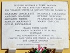
The inscription on the façade of the Tiro a Segno (shooting club) at number 28 on the left records nine partisans who died while resisting the Fascists. The most famous of these was
Mario Grecchi, who was severely wounded near Perugia while leading a company of partisans against a German battalion in 1944, when he was still only 18. He was kept alive long enough to face death by firing squad outside the Tiro a Segno.
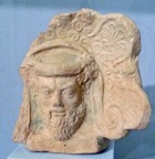
A terracotta antefix (late 4th century BC) of the satyr Silenus was discovered here in 1893. This suggests that there was an Etruscan temple nearby, which would have been between the Etruscan city and the Frontone Necropolis (below). The antefix is now in the
Museo Archeologico.
Return to Borgo XX Giugno and continue along it to the church of the
Madonna di Braccio at number 29 on the right.
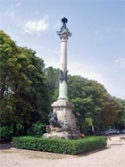
Continue to the monument (1909) ahead on the right, which was designed by
Guglielmo Calderini and installed on the 50th anniversary of the massacre of 20th June, 1859.
The monument stands in front of the Giardino di Frontone. In the early 15th century,
Braccio Fortebracci created the Piazza d' Armi here, inside his new stretch of walls, for the drilling of soldiers. His successor,
Braccio di Malatesta Baglioni turned it into a pleasant spot in which the Perugians could enjoy peace and occasional public spectacles. The area subsequently fell into disuse until it was laid out in formal gardens the 18th century. The small stone amphitheatre and small triumphal arch at its centre date to this period. Finds from an Etruscan necropolis (4th - 3rd centuries BC) here that was excavated on a number of occasions in the period 1840-1905 are exhibited in the
Museo Archeologico.
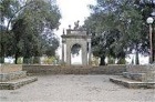
On leaving the park, cross Borgo XX Giugno to the
Abbazia di San Pietro. The main road originally followed the line of the side road (to the left) that you follow through the entrance to the abbey. It was diverted to the right in 1587 in order to allow the monks to extend their grounds.
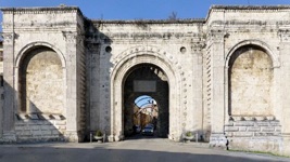
Continue along Borgo XX Giugno to
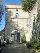
Porta San Costanzo. (If you have followed the suggested walk around the grounds of the Abbazia di San Pietro, you will emerge farther along Borgo XX Giugno, with the gate immediately on your left). This new gate was opened in the city wall when the road was diverted in 1587.
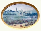
This watercolour (ca. 1860) in the
Museo dell' Accademia di Belle Arti, which is attributed alternatively
to Cesare Martinelli or Napoleone Verga, shows the arrival of papal forces at Porta San Costanzo on 20th June 1859, which marked the start of a day of carnage.
Walk through the gate, cross the road and take the steps to the left down to the church of
San Costanzo.
Retrace your steps to Porta San Costanzo and turn right before it along Via Benedetto Bonfigli. This road passes below and behind the apse of the San Pietro (above) and then through a short tunnel and along the line of the wall that
Braccio Fortebracci had built early in the 15th century.
A detour is possible from here to the ex-monastery of SS Trinità. (It involves a walk of about 2 km return along a busy road, but there are lovely views to the left).
Turn sharply right before passing through the gate and walk along Via San Girolamo. The ex-church is at number 204 on the left. Retrace your steps to Porta San Girolamo.
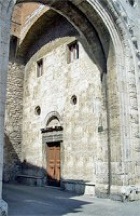
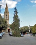
Walk through Porta San Girolamo and continue along Via Benedetto Bonfigli. The cinema on the left occupies the ex-convent of
San Girolamo. (This photograph looks back towards the city gate, visible on the left).
The ex-church opposite (at number 6) and the two buildings to the right of it formed part of the
Ospedale di San Giacomo.
You have now returned to Porta San Pietro.
Continue straight ahead along Via Santa Anna and walk down the steps into Viale Roma. Take a short detour by turning left along Viale Roma as far as the junction with Via del Villagio di Santa Lucia on the right.
Porta dei Ghezzi opposite (in a small car park) belonged to the walls that
Braccio Fortebracci built in ca. 1420. Substantial stretches of these walls survive to the right of the gate, extending along Viale Roma to Porta San Costanzo (see above).
The walls also ran to the left of the gate (across Viale Roma) towards Santa Giuliana:
-
✴The watercolour (1876) by Giuseppe Rossi on the leftt, which is in the Museo dell’ Accademia di Belle Arti, shows the wall at the centre (with San Domenico above).
-
✴The photograph to the right, which is taken from the entrance to the garden on the opposite side of Viale Roma from the gate, shows the line of the walls to Santa Giuliana in the distance.
Retrace your steps along Viale Roma and continue to the ex-church of
Santa Maria degli Angeli, which is set back in a shale piazza on the left. This church became known as Santa Maria dei Fossi in ca. 1420 in reference to the defensive ditches (“f
ossi”) in front of the new city walls here.
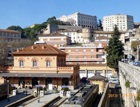
The road now passes the Stazione Sant’ Anna, below and to the left, which belongs to the privately-owned
Ferrovia Central Umbra (
FCU).
Continue ahead and take the pedestrian steps on the right (as the road swings to the left) up into Via Marconi. Cross the road with Tre Archi (see above) on your right. The distinctive circular tower at the back of Palazzo della Penna (see below) is in front of you.
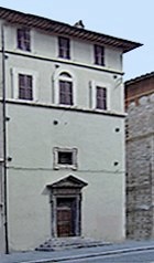
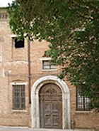
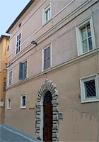
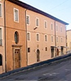
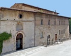
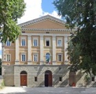
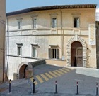
Continue up the stepped Via Vibi, which runs along the side of the palace of the Vibi family, later
Palazzo della Penna. The palace stands on what seems to have been the site of the
Roman amphitheatre. Turn left at the top into Via Podiani, which is named for
Propero Podiani, the famous scholar who donated his collection of books to the city in 1582. The entrance to Palazzo della Penna (illustrated here) is on the left. The palace houses an interesting collection of Baroque and modern art.
On leaving Palazzo della Penna, turn right along Via Podiani and left at the end along Corso Cavour. Continue up the stepped Via di Sant’ Ercolano and right at the end along Via Oberdan into Piazza Matteotti (see Walk II for this part of the route). Walk the length of the piazza and turn left along Via Calderini into Piazza IV Novembre, where the walk ends.