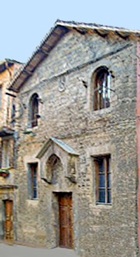
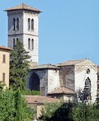
Rione di Porta Sant' Angelo,
with Sant' Agostino on the right
This walk begins in Piazza Danti (which is described in Walk I).
Leave the piazza along Via Bartolo, which was re-named in 1871 in honour of the jurist Bartolo di Sassoferrato. This street was built in 1378 on the line of the moat that had run along the western side of Fortezza di Porta Sole. It was originally known as Via Nuova, to distinguish it from the parallel Via Vecchia, now Via Ulisse Rocchi (see Walk II).
Continue past a series of interesting palaces:
-
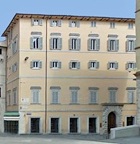
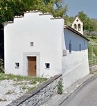
✴Palazzo Oddi Baglioni at number 2-16 at the start, on the left, illustrated here;
-
✴the ex-Sapienza Oradina at number 34;
-
✴Palazzo Negri - Friggeri - Cinelli (17th century) is at number 40; and
-
✴Palazzo Balioddi degli Oddi at number 54.
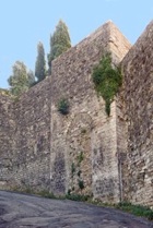
Continue past an interesting zig-zag section of Etruscan wall to
Arco Etrusco on your left (see the end of
Walk II) and Piazza Fortebracci. The piazza is named for for
Braccio Fortebracci, who ruled Perugia in 1416-24.
The campanile of the ancient church of
San Fortunato was on you right as you approached the piazza, and its facade is to the right in the piazza.
Walk down the right side of San Fortunato, along Via Pinturicchio, to see the remnants of an Etruscan monument embedded in the wall of the house behind the church, at number 11.
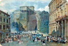
Retrace your steps into Piazza Fortebracci to Arco Etrusco and look out across the piazza in front of you. The papal legate, Cardinal Marino Grimani created this piazza in 1536, and it was known as Piazza Grimana until 1871, when it received its current name. This watercolour (ca. 1870) in the Museo dell' Accademia di Belle Arti, which is attributed alternatively to Cesare Martinelli or Napoleone Verga, shows a celebration in Piazza Grimana. The imposing Palazzo Gallenga Stuart, which is now the headquarters of the Università Italiana per Stranieri (University for Foreigners) can be seen on the right (and is on your left). It is worth taking the stairs up to the roof for magnificent views of the city.
Turn left left as you leave Palazzo Gallenga Stuart and take a short detour ahead along Via Bulagaio (with the bar on your right). Until 1536, Arco Etrusco had been been linked to this street by a bridge across a ditch known as the Fosso del Bulagaio. The word “
Bulagaio” might derive from “
boia” (executioner), since the first house on the right was the the residence of this official. This road, which probably follows the line of an Etruscan predecessor, leads to
Porta Bulagaio.
Take a short detour by passong through the gate continue for about 700 meters to see the small church of
Santa Maria Consolatrice degli Afflitti (often called the Santuaria della Madonna dei Cenciarelli) on the left.
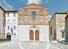
Retrace your steps to to Porta Bulagaio, with a fine view of the apse of Sant’ Agostino (below) on the right and of the wall of Borgo di Porta Sant’ Antonio on the left. Turn right along Via Bulagaio and immediately right up the narrow steps of Via dei Barutoli. Turn left at the top along Via Dei Pellari and right along Corso Garibaldi.
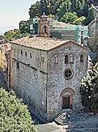
Corso Garibaldi forms the spine of the Borgo di Porta Sant’ Angelo, one of the suburbs that grew up outside the Etruscan city walls in the 13th century. Cardinal Grimani built stretch of this road behind you in 1871 to link his new piazza (now Piazza Fortebracci - above) to the important church of Sant’ Agostino (below): access to it had previously been from Via Bulagaio.
Sant’ Agostino is in a piazza to the right that was originally known as Piazza Sant' Agostino.
-
✴The Oratorio di Sant’ Agostino is to the right of the church.
-
✴The ex-convent to the left of the church is now a barracks.
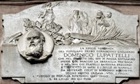
The piazza was re-named in 1871 as Piazza Lupattelli, in honour of
Domenico Lupattelli: a plaque on the left (as you look at the facade of the church) records this Perugian patriot, who was captured and executed in 1844 while fighting against the Bourbon monarchy in Calabria. (His remains were returned to Perugia in 1868 and are in the Monument to the Fallen in the
Cimitero Civico (cemetery).
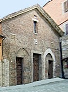
Continue along Corso Garibaldi. The arms of the Collegio della Mercanzia (a griffin on bales of cloth) appear on a number of the buildings in the block 84 - 96 on the left. These include the old church and hospice of
Sant’ Egidio at number 84 - 88.
The ex-church of
San Cristoforo is at number 106. [This housed a hookah bar, “Dubai - Perla del Deserto”, at the time of my visit in August 2013, when it was closed for holidays]. When this church was first documented in 1287, it was just inside the city walls. The nearby
Porta San Cristoforo was documented in 1273, when the road between it and Arco Etrusco (then called Porta Sant’ Angelo) was paved. This gate and the adjacent walls were demolished in the 14th century because the suburb had by that time extended as far as the present Porta Sant' Angelo (see below). Vestiges of Porta San Cristoforo that survived in the 19th century have since disappeared.
Two interesting buildings stood just beyond the walls, probably on the right:
-
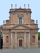
✴the Oratorio di Santa Maria della Consolazione, which seems to have been located at number 138 (now the Casa del Popolo, illustrated here); and
-
✴the church of Santa Maria Annunziata and an associated hospice, which may have been at number 153-7 (now the unlikely premises of a gymnasium).
Turn left along Via Benedetta, which runs along the right wall of the Casa del Popolo. The entrances to the church and the ex-nunnery of
San Benedetto dei Condotti is opposite, at the point at which this street swings to the right. Take a short detour down the steps to the right of the church to see its distinctive campanile. These steps follow the line of the medieval aqueduct: the term “
condotti”, which means of the culverts, is a reference to the aqueduct).
Return to and continue along Via Benedetto, with the ex-nunnery on your lrft. The street then swings to the right to rejoin Corso Garibaldi. Turn left along it, past:
-
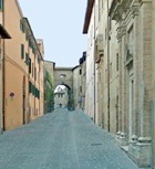
✴the church and nunnery of Santa Caterina Nuova, at number 175-9 on the right, immediately on the right in this photograph; and
-
✴the ex-nunnery of Sant’ Antonio da Padova, which is the orange building on the left, on the corner of Via Benedetta.
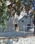
This road and gate were named for the now-demolished nunnery of
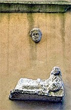
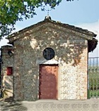
San Sperandio, which stood outside this gate. If you want to see the scant remains, continue through the gate and turn left at the T-junction to follow Via Sperandio. When this road swings left, carry straight on along Strada Sperandio. The student residence at number 5 incorporates part of the old nunnery and the tiny church (now a garage, illustrated here) still stands by the gate at number 3.
The nearby Ipogeo dello Sperandio can sometimes be visited (by previous agreement with the owners - I have not managed it yet). This Etruscan necropolis was in use from the 6th to the 4th century BC.
-
✴A sarcophagus (6th century BC) that was engraved with a procession of warriors was found here in 1843 and is now in the Museo Archeologico.
-
✴A small number of chamber tombs (5th and 4th centuries BC) were found nearby in 1857. Grave goods from them are also exhibited in the Museo Archeologico.
-
✴Another isolated vaulted chamber tomb (late 4th or early 3rd century BC) that had been cut out of the rock some 5 meters below ground was discovered in 1900. A number of pieces of gold jewellery from the floor of this tomb are now in the Museo Archeologico, Florence.
Return to Corso Garibaldi and turn right along it, towards Porta Sant’ Angelo (below):
-
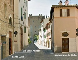
✴the ex-nunnery of Santa Lucia (now the the Conservatorio Antinori) is at number 226 on the left:
-
✴Via Sant’ Agnese, immediately beyond it, leads to the nunnery of Sant’ Agnese; and
-
✴the Cappella della Madonna della Stella is on the opposite side of Corso Garibaldi.
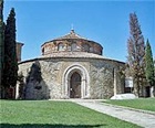
Via del Tempio runs along the right side of the Madonna della Stella to the ancient church of
Sant’ Angelo.
Turn right as you leave the church and take the steps down to
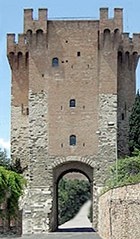
Porta Sant’ Angelo. Walk through the gate and look back to see a stretch of the wall (1321) to each side. Stairs to the right (as you look at the gate from inside the city) lead to the ramparts, and to the
Museo delle Porte e delle Mura Urbiche, a small museum that illustrates the history of the city walls of Perugia. (It has fantastic views).
Walk through the gate and take a short detour by turning left to follow the walls along Via Fuori le Mura. This closed gate below the nunnery of San Francesco delle Donne (below) might have been the
Porta dei Pasteni: it might have been the gate of this name in the inner wall that was documented in 1338 or another that took its name when the final circuit was completed shortly thereafter.
Return to Porta Sant’ Angelo and turn left along Via Monteripido, past the old church of
San Matteo degli Armeni on the left. The complex has reopened after its recent restoration: the ex-monastery houses part of the collection of the
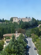
Biblioteca Augusta; and the church, which is used by the Orthodox community, is open for services on Sundays. The steep path forking to the left further along the road leads to the
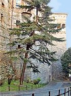
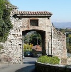
Convento di Monteripido (visible against the skyline in this photograph, which is taken from the Museo delle Porte e delle Mura Urbiche).
If the cloisters of the Convento di Monteripido are open, you can walk through the convent and leave along a lane that joins the road, which has become the Strada per Ponte d' Oddi: alternatively, retrace your steps to Via Monteripido and continue along it, with the convent wall on your left, into the Strada per Ponte d' Oddi. The ex-church of the nunnery of of
Santa Caterina Vecchia is at number 13, on the right.
Return through Porta Sant’ Angelo and turn immediately right along Via Faina, which was named in honour of Count
Zeffirino Faina, a member of the short-lived anti-papal government of Perugia in 1859-60. Turn right down the stony Piaggia della Torre. You will see the campanile of
San Francesco delle Donne on the right. Turn right and right again following the signs “Giuditta Brozzetti”: this refers to the co-operative founded by
Giuditta Brozzetti, which is located in the ex-church and which is dedicated to maintaining an old tradition of fabric production.
Return to Via Faina, continue down it and turn left at the end along Via Innamorati, which is named for the jurist
Francesco Innamorati (died 1923). The road passes the buildings of the University of Perugia in the ex-
Convento di Montemorcino Nuovo on the right. If the gate is open, it is possible (officially after having permission) to walk through the university garden, with the imposing wall of the monastery on your left and a fine view of
San Francesco al Prato on your right. Otherwise, continue into Piazza dell’ Università, with the conventual church on the right.
Continue along Via Fabretti (which is named for Ariodante Fabretti, a 19th century scholar and senator who published an important collection of Etruscan inscriptions) and right along Via dell’ Acquedotto, which subsequently merges with the stepped Via Appia (described in Walk III). Turn right at the end into Via Baldeschi, then immediately left along Via Cantine (described in Walk I). Turn right at the end, into Via Ulisse Rocchi: this takes you into Piazza Danti, where the walk ends.