
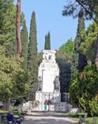
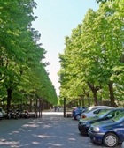
Piazza della Repubblica
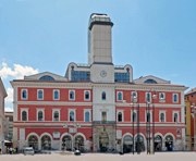
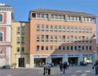
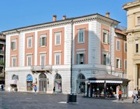
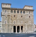
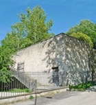
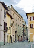
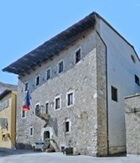
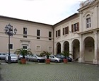
The walk begins in Piazza della Repubblica, which is on the site of the Roman forum. The ex-Palazzo Comunale (illustrated above), stands at the centre of this huge space. For the purpose of orientation, stand to face it:
-
✴a spur of Via Flaminia that became the cardo maximus passed along the line of today’s Corso Vecchio (to your left) and Via Roma (across the piazza, to your right); and
-
✴the decumanus maximus ran at right angles to it along the line of today’s Via Cavour (to your right and behind you) and Via Giuseppe Garibaldi (parallel to the right side of Palazzo Comunale).
The area has never been systematically excavated, but it is likely that the forum occupied not only today’s Piazza della Repubblica but also much of Piazza Solferino, behind Palazzo Comunale.
By the 11th century, the piazza was known as Platea Columnarum, in reference to a recovered Roman column that was erected here. This column was still standing in 1640, when it was depicted in a bird’s eye view of the city published by Domizio Gubernari. The Roman capital that has been embedded in the wall of the shops to the left of the church of San Giovannino (see below), near the junction with Via Roma, probably came from this column. Later in the Middle Ages, Piazza della Repubblica became known as Piazza Maggiore. The remains of a Roman temple were found here in the 1940s.
Begin a circuit of Piazza della Repubblica at the north end, to the left of Palazzo Comunale.
-
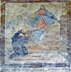
✴Luigi Manni, a prominent local politician, built Palazzo Manni (1835) here, incorporating a number of earlier structures. He provided a room in the palace, free of charge, for the first Cassa di Risparmio (savings bank) in Terni in 1846. The palace was cut off at the left when Corso Tacito was opened up in 1870. [A fresco of the Virgin adoring the baby Jesus, which was discovered on the facade in 1995, is attributed to Benozzo Gozzoli.]
-
✴Continuing in an anti-clockwise direction, the first palace on the west side of the piazza stands on the site of Palazzo di Cremesina Paradisi, which housed the Monti di Pietà from its inception in 1467. This palace was demolished when Corso Tacito was opened, and the Monti di Pietà moved to Palazzo Mazzancolli in 1879. Cesare Bazzani designed its replacement, Palazzo Pontecorvi (1902-16), for the Pontecorvi family. Spartaco Pazzaglia opened his famous cake shop on the ground floor of the palace in 1913.
-
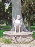
✴The Fontana di Piazza (1684), which stood to the left and in front of Palazzo di Cremesina Paradisi, was demolished in 1887. (You will see two sphinxes from the fountain later in the walk).
-
✴Cesare Bazzani also designed what is now the ex-Palazzo delle Poste (1921-36). In 2000, during work on the construction of a new underground car park behind the palace, traces of a Roman basilica were found. Architectural fragments from these excavations are exhibited in the Museo Archeologico.
-
This was previously the site of the church of San Giovanni Decollato (1566-76), which belonged to the Confraternita di San Giovanni Decollato. Its facade was completed (or perhaps rebuilt) in 1748. The church was demolished in 1921. Architectural fragments from the church are preserved in the Civic Lapidiary Collection. Piazza di San Giovanni Decollato, behind Palazzo delle Poste, is the only other reminder of the church.
-
✴Palazzo Giocosi (15th century) is the next palace to the left. Buildings in front of it were demolished in the 19th century and its facade was rebuilt to line up with that of San Giovanni Decollato.
-
Traces of the original palace survive at the corner on the left, in Via Cavour.
-
✴Palazzo Mariani, which was part of the post-war reconstruction of Terni, overshadows the church of San Giovannino (see below).
From Piazza della Repubblica to the site of Porta Romana
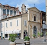
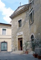
Leave Piazza della Repubblica along Via Roma, following the Roman cardo maximus. The church of San Giovanni Evangelista de Platea (San Giovannino) is on the corner, on the left. The Roman capital mentioned above is embedded in the left wall.
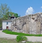
Continue to Viale del Cassero: the point at which this street joins the piazza corresponds to the probable location of the Porta Romana, at the south end of the walled city. The street is named for the Cassero (fortress) that Cardinal Gil Albornoz built here in ca. 1354. It was demolished in 1442. The church of Santa Maria del Cassero, which was built here in 1546, was demolished in 1841.
Turn left along Via Quattro Macine and follow it behind and then along the side of the petrol station to the junction with the busy Via XX Settembre, to the junction with Corso del Popolo.
Turn left along Corso del Popolo, which was laid out in the 1960s to provide a modern entrance to the city. The bridge across the river (which you saw from the footbridge) stands on the site of Ponte Romano (1605), which was destroyed in the bombardment of the Second World War.
Cross the roundabout and take the next turning on the left along Viale dell’ Annunziata. This street is named for the Franciscan nunnery of SS Annunziata, which was demolished in the 1960s when Corso del Popolo was opened up. Continue back to Piazza Briccialdi.
From the site of Porta Romana to Porta Sant’ Angelo
From Porta Sant’ Angelo to Piazza della Repubblica
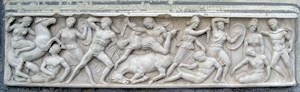
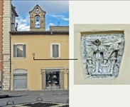
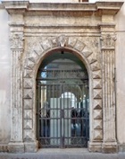
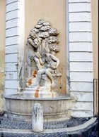
With Porta Sant’ Angelo behind you, walk along Via Cavour, which was the decumanus maximus of the Roman city. There is a Roman sarcophagus with a relief of a battle between Roman soldiers and Amazons (illustrated above) embedded in the wall at number 111 on the left.
Turn left on leaving San Francesco, cross the piazza and continue along Via Nobili. Turn right along Via Frattini. This was previously part of the Via delle Carrozze, which (as noted above) provided a route suitable for carriages traveling from the Duomo to Porta Spoletina (see below). This takes you back to Via Cavour: turn left to Largo Gregorio Mazzancolli:
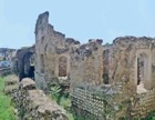
Turn right along Via Tre Colonne. Remains of the Roman theatre have been found in many of the houses in the “island” formed by Via Tre Colonne, Via XI Febbraio (which is parallel to it, to your right), and the two roads that connect them: Via del Teatro Romano and Via Ludovico Aminale.

-
✴continue along Viale Giannelli and turn left along Via dell’ Anfiteatro Fausto into Piazza del Duomo; or
-
✴retrace your steps as far as the left transept of the Duomo and turn right through the courtyard of Palazzo Vescovile to reach the piazza.
In any event, it is worth making sure that you see the substantial remains of the amphitheatre in Via dell’ Anfiteatro before exploring Piazza del Duomo.
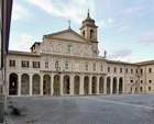
Bishop Cardinal Francesco Angelo Rapaccioli was responsible for the harmonious layout Piazza del Duomo as part of his project of rebuilding the Duomo in 1653. Gian Lorenzo Bernini may have played some part in the design.
Leave Piazza del Duomo along Via dell’ Arringo, which was probably named for public meetings (literally “harangues”) that were held here in the Middle Ages. Turn left at the end along Via Roma, back Piazza della Repubblica, where the walk ends.