
Terme di Fontecchio and Santa Maria di Belvedere
This excursion is described as a walk to both the Terme di Fontecchio and the Santuario di Santa Maria di Belvedere in a single expedition, which takes about 3 hours. However, you can do it as two walks, or alternatively by car.
Leave Piazza Matteotti along Via Angeloni into Piazza Raffaello Sanzio and turn right along Via Albizzini. Turn left into Piaza Garibaldi, passing the long facade of Palazzo Vitelli a Porta Sant' Egidio (visited in Walk II) on your left. Bear left Viale Vittorio Veneto, cross the roundabout, and continue along Viale Raffaele de Cesare.
To the Terme di Fontecchio
Take the 2nd turning on the right (Via delle Terme), which is sighed to the Terme di Fontecchio. This is an asphalt road, but traffic is light and the peaceful surroundings attract local walkers and joggers.
The Cimitero Monumentale (cemetery) on your right marks roughly the halfway point.
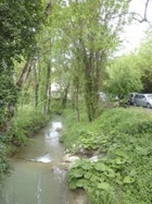
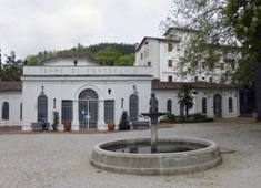
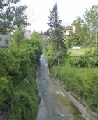
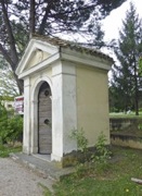
The entrance to the Terme di Fontecchio is in front of you, at the point at which the road crosses the Scatorbia and swings to the left.
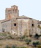
[The Fonte dei Cappuccini is about 1 km away also forms part of the modern complex. The original Convento Eremo dei Cappuccini here now serves as a guest house.]
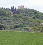
From Terme di Fontecchio to Santa Maria di Belvedere
Follow the road as it swings to the left. This is the CAI 105 footpath (signed to Colle Plinio), and is way marked by red and black signs. The tarmac soon gives out, but it continues as a wide, albeit unmade road.
When the road reaches the outskirts of Città di Castello, the way marks indicate that you should turn left, then right, then left again. The path become much narrower after the last of these turns and passes through a farmyard before reaching Viale Aldo Bologni. Turn right up along the main road, which is not particularly busy, albeit that the traffic is fast and the road is much-loved by speeding motor cyclists.
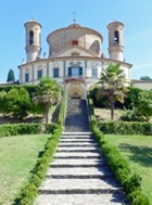
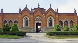
From Santa Maria di Belvedere to Città di Castello
Walk back along Viale Aldo Bologni. Just beyond the point at which you first met this road, it swings right, but you can continue ahead along the quieter old road (still Viale Aldo Bologni) to the roundabout at the junction with Via Palmiro Toglati.
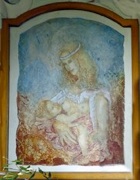
An aedicule on the left here contains a fresco of the Madonna del Latte that gives its name to the neighbourhood.
Continue along Viale Aldo Bologni and then Viale Raffaele de Cesare into Piazza Garibaldi, where the walk ends.
Longer Excursions
To Canoscio, Petroia and Morra
This excursion is some 20 km in each direction.
From Città di Castello, cross the Tiber and continue along Viale Nazario Sauro. Fork right along Via Cortonese. Continue to Fabrecce, where you turn right and right again along Via Luigi Pincardini and follow the road as it twists and turns.
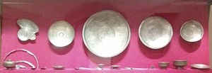
A turning on the left leads to the Colle di Canoscio. This hill was the find spot in 1935 of the Treasure of Canoscio (6th century): 25 pieces of magnificent altar furniture that are now in the Museo del Duomo. The two churches on the hill are described in Bill Thayer’s website:
-
✴the ancient SS Cosma e Damiano; and
-
✴the Santuario Madonna del Transito di Canoscio (12 Viale Lazzaro Vitellozzi).

To Umbertide
Umbertide is some 20 km south of Città di Castello. It can be reached by car or by means of the Ferrovia Centrale Umbra (FCU).
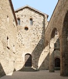
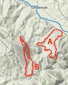
If you do so, you can walk from Piazza San Francesco in Umbertide (the site of the Museo di Santa Croce (see below), to the Abbazia di Monte Acuto in about 1 hour. Another hour from there takes you to the associated Eremo di Monte Acuto, further up the mountain. (Note, Monte Acuto is also known as Monte Corona.)
-
✴one that includes the abbey and hermitage (A); and
-
✴another that visits the pre-Roman sites above (B).
Museo di Santa Croce
This museum is housed in the ex-church of San Francesco. Some of the large number of votive bronzes (6th-4th centuries BC) that were found during excavation in 1986-95 of a sanctuary at the top of Monte Acuto (see below) are now exhibited here.
[Details of its important art collection]
To the Abbazia di San Salvatore di Monte Acuto
To the Eremo di Monte Acuto
Ancient History
Monte Acuto was the site of at least two pre-Roman fortified settlements, one identified by the ruins known as the Castelliere di Cima Cerchiaia (at 700 meters) and the other at the summit (at 923 meters). The votive bronzes in the Museo di Santa Croce (above) came from a sanctuary on the latter site.
To Pliny’s Tuscan Villa (1st century AD)
To the Pieve de’ Saddi
This website contains details of opening times.