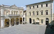
This walk begins in what was the eastern part of Piazza Matteotti, which was renamed as Piazza Valerio Gildoni in 2011 on the second anniversary of the tragic death of this policeman in the course of duty.
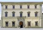
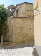
The side wall of Palazzo Vecchio Bufalini (to the right in the photograph above) was originally obscured by the church of San Fortunato. This part of the piazza began to take on its present form when the church was demolished in 1899. The side facade of the palace was built at about this time. Other buildings to the left of it were demolished thereafter to make way for the Palazzo della Cassa di Risparmio (1901-12).
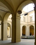
The arch to the left of Palazzo Vecchio Bufalini leads to its loggia, which was covered in glass in 1905-8. This is now a public space, and houses the Tourist Information Office (ahead, on the right) and Ristorante Le Logge (on the left).
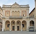
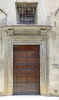
Leave the loggia by the arch to the right of the Tourist Information Office, into in Piazza Andrea Costa, and look back at the main facade of Palazzo Vecchio Bufalini.
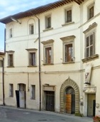
Palazzo Bourbon del Monte (16th century), which is opposite Palazzo Bufalini (at number 1-3 Piazza Andrea Costa) houses the Laboratorio di Tessitura Tela Umbra, founded in 1909 by Alice Franchetti in order to conserve traditional textile manufacture.
Take a short detour along Via Sant’ Antonio, which runs between these two palaces. It is named for the church of Sant’ Antonio Abate, which is on the left at the end of the street.
Rione Sant’ Egidio
Return to Piazza Matteotti and turn right along Via Mario Angeloni Continue to Piazza Raffaello Sanzio.
-
✴The monument (1910-4) at the centre of the piazza, which is dedicated to the liberation of the city from papal control on 11th September 1860, is by Elmo Palazzi.
-
✴The church of San Francesco stands behind it. The name of the piazza recalls an altarpiece by Raphael that was “received” by the commander of the French army that “liberated” the city in 1798.
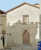
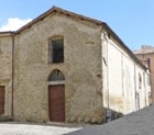
Take a short detour further along Via Angeloni: the ex-church of Sant’ Egidio is at number 12 on the left.
Continue the detour by turning left along the right wall of Sant’ Egidio (ie. along Via Guelfucci). Take the first turning on the right (Via Cerboni). The campanile of the building at number 5 on the right is all that remains of the Monastero di SS Benedetto ed Egidio.
Retrace your steps to Piazza Raffaello Sanzio and turn left along Via Albizzini, which runs behind the apse of San Francesco. The “Galleria delle Arti” at number 21a on the right is housed in the ex-Monastero di San Giuseppe, which closed in 1814 and was absorbed by the Monastero di Santa Cecilia in Paradiso (below).
Palazzo Albizzini (15th century), which is on the left at the end of the street, houses part of the Collezione Burri.
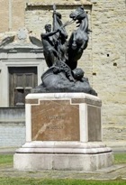
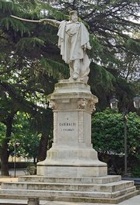
Continue past the main facade of Palazzo Vitelli a Sant’ Egidio (below) into Piazza Garibaldi, which was laid out in front of these palaces in the 19th century. The statue (1887) of Giuseppe Garibaldi by Arnaldo Fazi di Firenze stands on a base designed by Guglielmo Calderini.
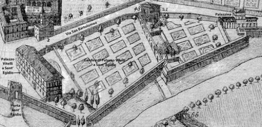
Detail from the plan (ca. 1675) of Città di Castello
by Filippo Titi (Biblioteca Comunale “Giosue Carducci”)
Return to look at the main facade of Palazzo Vitelli a Sant’ Egidio. Porta Sant’ Egidio was originally in the walls here, at the right end of the palace.
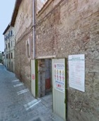
Leave the piazza along Via San Bartolomeo, which passes the left end of the palace and continues along the wall of its extensive garden. The street is named for the ex-church of San Bartolomeo [2] on the left. The church is now a pasta shop and is only recognisable as an ex-church because its campanile can still be seen from the space behind it.
Follow the wall of the garden of Palazzo Vitelli (on your right) along Via San Bartolomeo to the junction with Via dei Lanari, which is named for the Arte della Lana (wool workers’ guild). Their abandoned church (15th century) of Santa Maria della Neve [48] on the right at this junction is now in the garden of the palace. (It was also known as Santa Maria dell’ Arco because it stood above an arch over the canalised river Scatorbia. )
Continue to the Palazzina Vitelli, at the far end of the palace garden (which is described in the page on the palace).
Follow the path to the right, as it curves behind the Palazzina, and cross what was the line of the city wall into Viale Armando Diaz. As you look back, the city walls to the left form the other wall of the garden of Palazzo Vitelli a Sant’ Egidio.
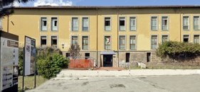
The Liceo Ginnasio "Plinio il Giovane" in front of you (at 2 Viale Armando Diaz), occupies part of what was the Monastero delle Giulianelle (more formally known as the Monastero dello Spirito Santo). Retrace your steps to Via San Bartolomeo (round the left side of the school) and continue Via delle Giulianelle. The Biblioteca Comunale “Giosue Carducci” on the right occupies another part of the ex-nunnery.
Rione San Giacomo
Return to the entrance of the Liceo Ginnasio "Plinio il Giovane" and continue along Via Campo dei Fiori, which runs along the inside of the city wall. It passes a park on the right that has been established on the foundations of a bastion in the city walls that was known as the Torrione delle Giulianelle.
Continue along the “pomerio”, still following the wall
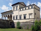
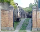
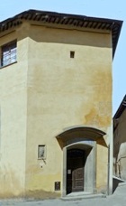
Just before the brick pillars at the end of the road, you pass the workshop of the sculptor Elmo Palazzi in the garden of Villino Palazzi. (This workshop is on your right, but on the left in this photograph looking back).
Villino Palazzi itself is on your right as you emerge (from the extreme right in this photograph) into Via XI Settembre (originally Via San Giacomo). Porta San Giacomo stood to the left of it until it was demolished in the 20th century.
[Ospedale di San Giuliano]
Turn left along Via XI Settembre, which is named for the date in 1860 on which Città di Castello was liberated from papal control. Piedmontese forces entered the city though Porta San Giacomo.
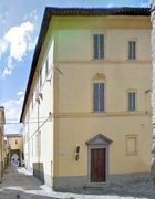
The ex-Palazzo Tini, at number 34 on the right, now houses the
Istituto Sacro Cuore, which belongs to the
Piccole Ancelle del Sacro Cuore. This complexnow extends across the entire “island” bounded by Via XI Settembre, Via San Girolamo and Via Trastevere, and includes an old people’s home and the nuns’ church of Santa Lucia.
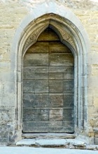
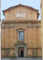
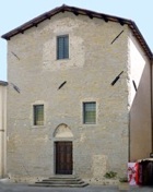
The shop on the left at the junction with Via San Giorgio was once the parish church of San Giorgio.
The church of Santa Maria delle Grazie is opposite. Continue to the junction with Via del Gonfalonieri and turn right along it into Piazza dei Servi, to see its campanile, the side entrance to the church, and the entrance to the adjacent oratory.
Leave the church by the side door and turn right to continue along Via del Gonfalonieri. Turn left along Via Santa Maria delle Grazie: the rear and campanile of San Michele Arcangelo are at the end. Turn right here, along the left side of the church, and then left into Via Sant’ Angelo to see its facade.
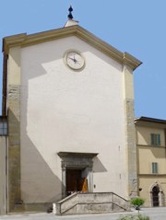
Continue along Via Sant’ Angelo and turn right along Via Sant’ Andrea, which becomes Via del Vingone. Continue along the right side of San Giovanni Decollato, the facade of which is in Pomerio San Girolamo.
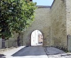
Continue along Via del Vingone to Porta Sant’ Andrea. This gate was opened in the walls in 1475, and Nicolò Vitelli entered by it when he retook the city in 1482. It was subsequently closed, but re-opened in 1945.
Detail from the plan (ca. 1675) of Città di Castello
by Filippo Titi (Biblioteca Comunale “Giosue Carducci”)
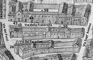
Retrace your steps along Via Sant’ Andrea and turn right along Via della Fraternita:
-
✴Look first at the buildings on the right:
-
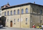
•the Ospedale di Santa Maria della Misericordia [58], which was also known as the Ospedale della Fraternita (presumably because it was operated by a lay confraternity), and gave its name to the street;
-
•the Monastero di Santa Maria Maddalena [44]; and
-
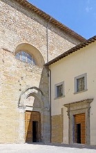
Nunnery of Santa Cecilia in Paradiso Aedicule San Giuseppe
(number 1) (number 3)
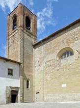
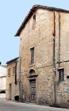
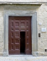
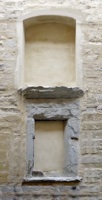
Now walk back to see the complex of the Monastero di Santa Cecilia in Paradiso, which was formed in 1658 on the merger of Monastero di Santa Cecilia [26] and the adjacent Monastero del Paradiso [30]:
-
✴the ex-church of Monastero del Paradiso at number 1 became the nuns’ parlour after the merger of 1658;
-
✴a low closed window further along, with an aedicule above, was probably originally a place where abandoned babies could be left; and
-
✴the nuns’ “new” church of San Giuseppe is at number 3.
In fact, the nunnery occupied most of the “island” formed by:
-
✴Via della Fraternita;
-
✴Via Sant’ Andrea;
-
✴Via del Paradiso; and
-
✴Via dei Fucci.
Walk around the complex by first turning right into Via Sant’ Andrea. The original entrance to the nunnery on your right is now almost unrecognisable.
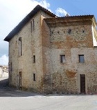
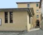
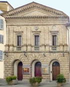
Turn right again, along Via del Paradiso and continue to the junction with Via dei Fucci. According to the plan above by Filippo Titi, the original church of Santa Cecilia [26] was on the left here. The building on the opposite side of Via del Paradiso (illustrated here), which stands on what was a vacant site in the Titi plan, is the ex-Oratorio di Santa Cecilia. [I have yet to find out when it was built]. It now houses the “Teatro dei 90”.
Take a short detour by turning right along Via dei Fucci, which is named for the traditional enemies of the Vitelli family. Teatro degli Illuminati is at number 14 on the left.
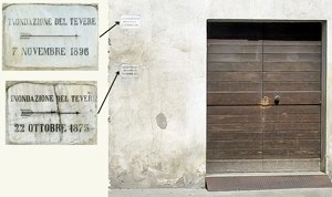
Inscriptions opposite (near the junction with Via della Fraternita) show the level to which the Tiber rose during the floods of 1875 and 1896.
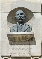
Retrace your steps along Via dei Fucci and continue into Piazza Magherini Graziani, which is named for the historian Giovanni Magherini Graziani (died 1924). Palazzo Magherini Graziani (17th century) is at number 3 on the right. The bust (1926) of Giovanni Magherini Graziani on the facade is by Giulio Robbiati.
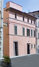
Palazzo Fucci (16th century), which was later owned by the Vitelli family, is opposite, at number 6. It now houses the Gelateria Pinzaglia Angiolina.
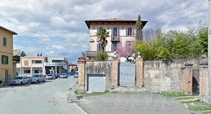
Continue to Via XI Settembre and take a short detour along it by turning left to the Palazzo Vitelli a San Giacomo (at number 18). Casa Battocchi opposite stands on the site of the original stables, which was used for a pensile garden after the Marchesi del Monte Santa Maria inherited the Vitelli palace in the 18th century.
Retrace your steps along Via XI Settembre and continue to the church of the Monastero delle Clarisse Murate , which stands on the site of the ancient church of San Giacomo alla Scatorbia. (The church gave its name to the district; the Scatorbia is a tributary of the Tiber that probably defined the northern boundary of the Roman city.) Take a short detour by turning left into Via dei Lanari to see the entrance to the nunnery on the left.
Return to Via XI Settembre and continue into Piazza Matteotti, where the walk ends.