

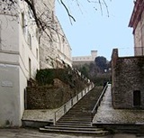
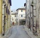
Walk I follows a route that is confined by the walls of the Roman city.
Roman Walls (4th - 1st centuries BC)
[History of the walls]
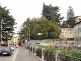
Via Cecili
-
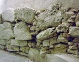
✴the irregular blocks of the pre-Roman walls (4th century BC);
-
✴the squared limestone blocks from the original walls of the Roman colony (ca. 241 BC); and
-
✴blocks laid during the restoration of the walls that was necessitated by the damage done by Sulla in 82 BC and by the earthquake of 63 BC.
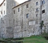
A long stretch of the Roman wall that was excavated in Viale Matteotti [link] during the building of a moving walkway in 2006. It is exposed inside the foyer, along with a plaster cast of a long inscription: the original inscription is in another important stretch of the walls in the private garden above, which once belonged to the Piperno family. It records the names of the two quattroviri who restored it: the existence of these magisterial posts suggests that the restoration was carried out after 90 BC, the date at which Spoleto became a municipium.
Via delle Mura Ciclopiche
Via Egio
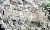
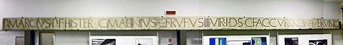
The foyer also contains this plaster cast of the whole inscription, which reads:
P[UBLIUS] MARCUS P[UBLIUS] F[ILIUS] HISTER
C[AIUS] MAENIUS C[AIUS] F[ILIUS] RUFUS
IIII VIR[I] I[URE]
D[ICUNDO] S[ENATUS] C[ONSULTO]
FAC[IUNDUM] CUR[AVERUNT] PROBAVERUNTQ[UE]
This records that Publius Marcus Hister, son of Publius and Caius Maenius Rufus, son of Caius, both of whom were “quattuorviri iure” (two of the four magistrates with judicial power), had been authorised by the local Senate to undertake what was presumably the restoration of the wall at some time after the earthquake of 63 BC.
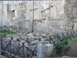
The explanatory panel says that the lower part of the wall in the garden is similar to that excavated in the foyer: both stretches are made up of large, irregular blocks without cement. However, the upper part of the wall in the garden has been rebuilt using smaller, regular blocks held together by cement. This was presumably the result of the restoration commemorated in the inscription. Some scholars have suggested that this work was carried out after 82 BC, when Sulla sacked the municipium. However, others believe that script used in the inscription dates to much later in the century.
Roman Gates
Arco di Monterone (ca. 241 BC)
The street level is much higher than it was in Roman times, so that the arch is less than half its original height.
Porta San Lorenzo (13th century)
Porta Fuga (13th century)
The inscription in the lunette between the two arches records that the gate is named in memory of the repulse of Hannibal when he reached Spoletium in 217 BC, having defeated the Romans at Lake Trasimeno.
Porta Ponzianino (13th century)
The soldiers of the Emperor Frederick I swept through the earlier gate when they stormed the city in 1155.
Return to Monuments of Spoleto.
Return to Walk II or
for the stretch of the Roman wall that coincides with the medieval circuit, to Walk III.