Key to Umbria: Assisi


Around Assisi


Umbria:  Home   Cities    History    Art    Hagiography    Contact 


Assisi:  Home    History    Art    Saints    Walks    Monuments    Museums 

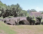
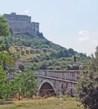
Ponti dei Galli and Ponte San Vittorino

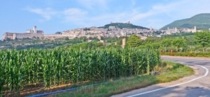
This walk of some 5 km explores the Tescio river, north west of Assisi.  Much of it is in the Bosco di San Francesco, which has been formally opened to the public by the Fondo Ambiente Italiano since my last visit.

Leave Porta San Giacomo along the shaded Via degli Episcopi.


This leads to the cemetery, which was established in 1863.  The view here is taken from Rocca Maggiore above.  This was the site of a Roman villa: a black and white floor decorated with fish that was found here  no longer survives. 


The cemetery church of Santa Maria degli Episcopi was first documented in 1291, when it belonged to a community of Benedictine nuns.  They moved to the nunnery of Santa Maria degli Episcopi in Via San Francesco in 1401.


Retrace your steps and fork right outside Porta San Giacomo, along Via del Ponte dei Galli.  This quiet road leads to the older of the two bridges of this name, which  was documented in 1166 as the Pons Gallorum.  According to local tradition, it takes its name from the fact that soldiers of the Emperor Charlemagne crossed it in 800 on their way to Rome.  The present bridge (1356) uses stones that might have come from a Roman predecessor.
The “Ospedale dei Galli” was documented here in 1276 and the “Monasterio Sancte Crucis de Ponte Gallorum" in 1316.  The nuns moved to the site of the present nunnery of Santa Croce inside the walls before 1382.  The remains of their original complex survive and now house the Fondazione Sorella Natura.   The church was under restoration at the time of my last visit (April 2011).


The mill (12th century) on the other side of the bridge, which belonged to the nunnery, was in use until the 20th century.  


There are two options for the next part of the walk:

  1. option I, along the road on the far side of the river; or

  2. option II, following the paths along the bank nearer to Assisi.

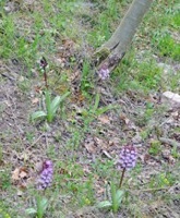
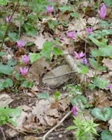
Both options have good views of the Sacro Convento in their later stages, although those from the road are better.  The woodland route offers wild orchids and cyclamen in the Spring.  You can change between them at the second Ponte dei Galli (see below).

Option I

Cross the river and fork sharp left and follow the road along the far bank.  There is a statue of Padre Pio at the road junction on the right.


Continue past another bridge that is also called Ponte dei Galli (1193).


Continue to Ponte San Vittorino (1283, rebuilt in 1514).  This was the site of the site of the martyrdom of St Victorinus and of the Monastero di San Vittorino, which was first documented in 1198 and documented again in the 14th century as a priory dependent upon the Abbazia di San Pietro (see below).  It was subsequently abandoned, but survived until the earthquake of 1832, when it finally succumbed.   Stones from the rubble were used in the rebuilding of Santa Maria degli Angeli.


Cross the bridge and walk along Viale Giovanna di Savoia, Regina dei Bulgari towards Assisi.  This road is named for Giovanna di Savioa, the daughter of King Victor Emmanuel III, who married Tsar Boris III of Bulgaria in 1930 (in a ceremony attended by Benito Mussolini) and who was buried in Assisi in 2000.  Fork left at Piaggia di San Francesco, where the two options above converge.

Option II

The start of the path along the bank of the river nearer to Assisi is blocked (as at April 2011) by the construction site around Santa Croce.  You therefore need to retrace your steps along the road, with the path below you on the right.  You can hurdle the safety barrier after about 50 meters and take the path you will see there that joins it. 

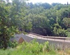
Continue to another bridge that is also called Ponte dei Galli (1193).  There are two paths ahead, either of which will serve your purposes: 

  1. The lower one, which is way-marked,  follows the river. 

  2. If you take the other one, which is the Selva di San Francesco, turn uphill at each opportunity, taking the wooden steps when you see them.  There were rockfall warnings on a short stretch of this path in 2011, but it was easily passable.  Continue along the path until it meets a track at a hairpin, and turn right to follow the track downhill.

The two paths meet just before a house, after which you turn left at Piaggia di San Francesco.

Options I and II converge here.
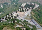
Piaggia di San Francesco (which has no exit for vehicles) leads steeply uphill towards Porta San Francesco, with the Sacro Convento on your left.  The Abbazia di San Pietro is below, to the right (on the skyline in this photograph).  The relics of St Victorinus were translated at an unknown time from San Vittorino (behind you) to San Pietro, and are still under the high altar there.


Continue to Porta San Francesco, where the walk ends.  


Monte Subasio

This circular journey from Assisi (13 km) is best done by car.  It takes in:

  1. the Eremo dei Carceri (which can alternatively be visited after a strenuous hike from Porta Cappuccini - see Walk I);


  1. the original site of Sant’ Angelo in Panzo (a turning on the right as you return to Assisi).

Rivotorto and Santa Maria degli Angeli

These two important churches and a number of smaller ones are linked here in a long but easy walk along the southern side of Assisi (about 14 km or 3 hours walking).  There are numerous options for shortening it, as will become clear. 

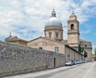
The walk starts with Santa Trinita and Santa Maria di Rivotorto: there is the option of taking the bus to the former, or missing it out (which would be a shame) and staying on the bus to the latter.

If you are walking, leave Porta Nuova along Via Dottor Valentin Mueller. 


Pass under the main road, fork left and then right and continue for about 2.5 km along the straight and pretty Via di Mezzo.  Cross Via Renaiola and carry straight on.  Turn right at the end along the busy Via Assisana (SS147).  After about 600m, turn right along Via Santa Trinità: the church of Santa Trinità is at the end, on the right.  The key is kept in the house to the right of the church. 


Continue to the junction before the motorway and turn right along Via del Sacro Tugurio, which runs roughly parallel to it.  The road is named for the Sacro Tugurio (sacred hovel), which was once the home of St Francis and his early followers: it is now within Santa Maria di Rivotorto, some 2 km along the road.


The War Cemetery of Assisi, just beyond Rivotorto, which contains the graves of allied soldiers who were mostly killed in 1944.


If that is enough for one day, the road between the church and the cemetery leads back to Assisi (3.5 km). 

If you want to continue, walk for another 2 km to the bend at which the road approaches both the motorway and the railway line.  The church of Santa Maria Maddalena is on the right and the key is kept in the house opposite.


Continue a little way (with the railway line to the left) and turn right along Via San Rufino d' Arce.  The metal gates of the Monastero di San Rufino d' Arce are on the right (opposite the cemetery); ring the bell in order to see the church of San Rufino in Arce.


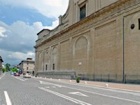
If that is enough for one day, continue along Via San Rufino d' Arce to Assisi (3 km).  However, Santa Maria degli Angeli is only 1.5 km away, and you can easily take the bus from there back to Assisi.

If you decide to continue, return to the main road and follow it to the level crossing on the left.  Cross the railway line and turn right along Via Protomartiri Francescani.   The excellent restaurant, La Basilica (075 804 491), is at number 11 on the right, opposite the apse of Santa Maria degli Angeli


You can now take the bus or walk back to Assisi from Santa Maria degli Angeli.

The walk is along the “Strada Mattonata” (brick road), which begins along the left side of the church.  The remains of the ancient pilgrim way were discovered during roadworks in 1990, and the path was relaid above using new bricks, each of which bears the name of a donor.


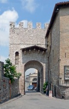
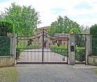
If you are walking, continue to this junction with Via Francesca on the right and Via Ospedale delle Pareti (from which this photograph was taken) on the left.  It was from this point that St Francis blessed Assisi in 1226 as his followers took him to Santa Maria degli Angeli to die.  The friars then carried his body back to this point and turned right along Via Francesca (on the right) to San Damiano, so that St Clare and her sisters could say their last goodbyes.


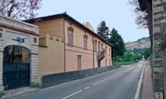
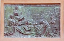
Villa Gualdi in Via Ospedale delle Pareti (behind you in the photograph) stands on the site of a medieval leper hospital, San Salvatore delle Pareti.   A relief on its facade depicts the dying St Francis blessing Assisi.

Continue towards Assisi and fork right along the pedestrian path.  The church of the ex-nunnery of San Nicolò dell’ Orto is on the right, just beyond the Pontificio Seminario Regionale Umbro 'Pio XI'.


Continue to Porta San Pietro, where the walk ends.


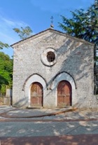
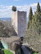
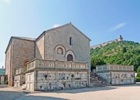
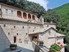
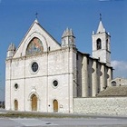
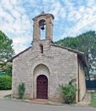
From Porta San Pietro to Rocca Sant’ Angelo

You might like to take a taxi from Porta San Pietro to Rocca Sant’ Angelo (some 13 km to the north west), to see the interesting rural church and convent of Santa Maria della Rocchicciola (sometimes called Santa Maria in Arce).


Return to Walks in Assisi.


Return to the home page on Assisi.