
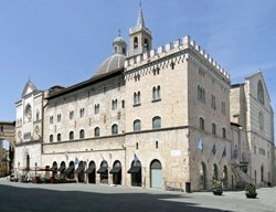
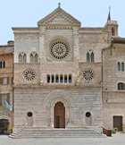
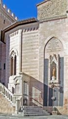
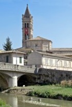
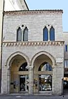
The walk begins in front of the main façade of the Duomo (at the extreme right in this photograph), which is in Largo Giosuè Carducci, the shorter part of the L-shaped Piazza della Repubblica.
-
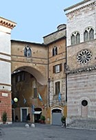
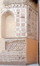
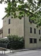
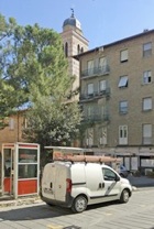
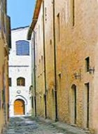
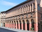
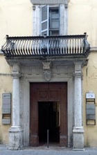
✴along Via XX Settembre on the left (illustrated here) to Porta San Giacomo; and
-
✴along Largo Carducci and Corso Cavour on the right to Porta Romana.
Everything in front of you as far as the city walls belongs to the Terziero Superiore. (See Walk II for Terzieri Mediano and Inferiore, which are behind you).
-
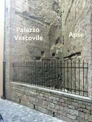
✴It replaced an earlier episcopal palace that stood to the right of the apse of the Duomo (see below).
-
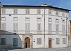
✴It was destroyed in the Second World War and rebuilt in 1955.
Walk under the arch that abuts Palazzo Vescovile, cross Via Gentile da Foligno and continue along the Vicolo dell’ Oratorio. The church of Santa Marta, which belonged to the Confraternita del Suffragio, stood just beyond on the right (at number 4) until it was demolished in ca. 1745. The confraternity then moved to their new Chiesa del Suffragio.
Take a short detour by turning left here, along Via dell’ Oratorio.
-
✴The apse of the Duomo, which was rebuilt in 1457-62, is on the left: you can see the vestiges of its original window.
-
✴Look back to see the remains of a wall of the old Palazzo Vescovile: as noted above, this palace was demolished in ca. 1565 to make way for a new sacristy.
This spot is also visited in Walk II.
Retrace your steps and turn left to continue along Vicolo dell’ Oratorio. Walk under the arch ahead, into Piazza Branducci. The ex-Oratorio del Buon Gesù is at number 15: it was largely destroyed in the Second World War and now houses now the Centro Sportivo Italiano.
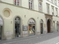
Retrace your steps under the arch, turn right along [name??] and right again into Via XX Settembre. This street, which is named for the day in 1870 that soldiers of the new Kingdom of Italy entered Rome, was laid out in 1880 to a plan by Vincenzo Vitali.
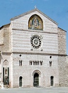
Turn right on leaving San Giacomo, continuing along Via XX Settembre towards the river. Three churches once stood on the left:
-
✴Santa Maria Casta;
-
✴Sant' Antonio Abate; and
-
✴Sant' Apollonia and the Ospedale di Santo Spirito (at number 79-85). This was originally the site of the church and Cassinese monastery of San Silvestro: the dedication was changed in 1311, when the monastery was transformed into a hospital and united with the Ospedale di Santo Spirito, Rome.
Detour (30 minutes return) to the aedicule of the Madonna delle Scuffiole,
the church of the Madonna della Fiamenga.
You can add another hour to the total time by continuing along the line of the Via Flaminia to see two Roman mausoleums, returning via the modern church of San Paolo Apostolo.
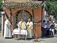
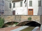
Cross the bridge and then the main road, turn right and immediately left, along Via Goffredo Mameli. The aedicule of the Madonna delle Scuffiole is on the left, just past number 31. It contains a fresco known as the Madonna delle Scuffiole, which depicts the Madonna del Latte: "scuffiole"(bonnets) refer to the head gear that was used for new babies, so the usual title of the image can be translated as the ‘Madonna of newborn babies’. It is believed to help mothers who cannot produce milk and to cure sick babies: even today, mothers hang their babies' bonnets here in the hope of improving their health. This was one of the oldest Marian images in Foligno, but it was repainted in ca. 1930. Mass is said here each 1st June: the photograph above shows the service taking place in 2008.
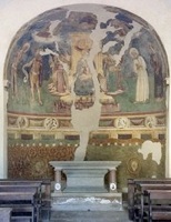
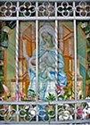
Turn left along Via Madonna delle Scuffiole, left again along Via Fornaci and immediately right along Via Asiago. Turn right at the end of the road, along leafy Viale Firenze. The interesting church of the Madonna della Fiamenga (13th century) stands on a road island ahead. This was the point at which the eastern branch of the Via Flaminia crossed Roman road from Foligno to Spello, as recorded in the the website of Bill Thayer. The church contains an important fresco by Pierantonio Mezzastris, which can be seen clearly through its glass door (if, as is usual, it is closed).
If you are ending the detour here, retrace your steps along Viale Firenze
and continue ahead across Ponte San Giacomo, where the detour ends.
Fast forward to the next yellow box to continue the main part of the walk.
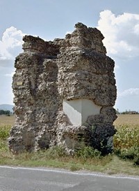
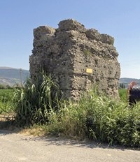
Mausoleum opposite Via Santo Pietro Mausoleum on Via della Chiona
If you are continuing the detour, turn left along Via Fiamenga (SR 316), following the line of the Roman Via Flaminia towards Bevagna. Continue to the city limit:
-
✴the first of these mausoleums is on the right here, with Via Santo Pietro opposite’ and
-
✴the second is also on the right, some 500 meters further along the road, at the junction with Via della Chiona.
Retrace your steps along Via Fiamenga to Via Santo Pietro and turn right along it (back towards Foligno). Turn left at the T-junction (still on Via Santo Pietro) to the crossroads: continue on Via del Roccolo (as Via Santo Pietro continues turns right).
Continue along Via del Roccoloe (turning right along Via Massimo Arcamone and immediately left to return to to it). Turn left at the end, along Viale XVI Giugno, with the river on your right, to the junction with Viale Firenze.
Turn right across Ponte San Giacomo, where the detour ends.
Turn right (or left if you are returning across the bridge, after the detour) to follow the city wall on your left along Via Bolletta, past the excellent Hotel le Mura at number 27.
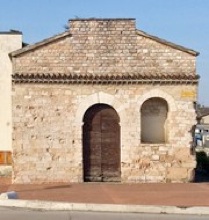
Cross Via Mentana and continue along Via San Giovanni Battista to San Giovanni Battista (at the end, on the left). Continue into Via dell’ Ospedale to the Ospedale Civile, which was built on the site of the monastery attached to the church in 1859, using a bequest from Gregorio Onori Piermarini. This imposing building is now in restoration (at April 2011). (Both the church and the hospital are discussed in the page on San Giovanni Battista (12th century) and the ex-Ospedale Civile (1740-50).
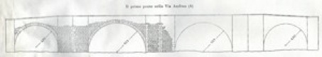
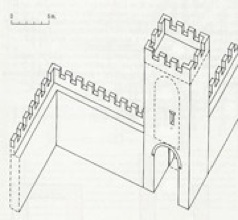
Reconstruction of Ponte della Carbonara by L.Crema (G. Dominici, referenced below, p. 31)
Arches 3 and 4 no longer survives, but their original existence is suggested by the symmetry

Continue along Via dei Molini, passing the left side of the ex-church and nunnery of SS Trinità in Annunziata, which has its facade in Via Garibaldi.
The two palaces on the opposite side of Via Garibaldi, which are connected by an overpass, were originally the components of Palazzo Barbetti Clarici:
-
✴The palace on the right (at number 140) now houses the Carabinieri. [Its chapel, which can sometimes be visited, contains frescoes (1924) by Gerardo Dottori].
-
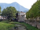
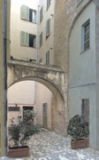
✴The palace on the left (at number 142) still belongs to the Clarici family, who operated the adjacent olive oil mill, frantoio Clarici (reached from the gate at number 144). It is sometimes possible to see the present oil production facility and the original oil mill behind it (illustrated here).
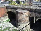
Turn left along Via Garibaldi (with the two palaces above on your right) to the junction with Via Bolletta to the left and Via Oberdan to the right. This was the site of Porta Badia (Porta Loreto or Porta Ancona), which was demolished in 1930.
-
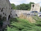
✴The canalised Menotre river in front of the wall was diverted underground in 1989: you can see part of its channel on your right.
-
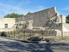
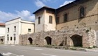
✴There is a long stretch of wall to the right side of Via Bolletta that has recently been restored. (The excellent restaurant ‘Mangiafuoco’ stands on the walls, just to the left of the stretch shown in this photograph).
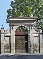
Retrace your steps along Via Garibaldi. Take a very short detour by turning left along Via dei Monasteri, which is so-named because it once contained no fewer than five nunneries. The first of these, the Dominican nunnery of Santa Maria del Popolo (1291), occupied the long building at number 1-5 on the left. (You will see the other four later in the walk.)
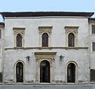
Return to Via Garibaldi and continue to Piazza Giacomini, on the left. The space for this piazza was created during the devastating bombardment of 1943, which destroyed the church of San Leonardo and the Convento di Sant’ Agostino. Fortunately, the venerated statue of the Madonna del Pianta in San Leonardo survived, and is now in the church of Sant’ Agostino (below).
-
✴the ex Canonica di San Salvatore, at number 4a-5; and
-
✴Palazzo Varini, at number 3-4.
Turn right along Via Nicolò Alunno (which still follows the line of the wall). The buildings on the left, which include Casa di Nicolò Alunno at number 19, were incorporated into Monastero di Sant’ Anna (below) in ca. 1549.
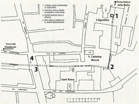
Continue to Via Umberto I, at the end of the street, and turn left:
-
✴The ancient parish church of Santa Maria Maddalena (marked 3 on the sketch map above) was demolished in the 19th century.
-
✴The Porta Antica della Croce, a gate in the walls of ca. 1240 that is marked 4 also no longer survives.
Retrace your steps along Via Umberto I to the ex-church of Santa Maria di Betlem on the right, at the junction of Via dei Monasteri (sketched but unnamed on the sketch map above), and take a short detour by turning right along it. This road, which is runs parallel to and between the walls of ca. 1240 and those of 1328, was so-named because it housed five nunneries:
-
✴Sant’ Anna is the only one of the five that is still in existence. The entrance to the church is at number 44 and the entrance to the nunnery is at number 46.
-
✴The other four, which were all on the right, are described in the page “Nunneries in Via dei Monsteri”
-
•Santa Maria di Betlem, at number 27-33, which also owned the church of this name in Via Umberti I (mentioned above);
-
•Sant’ Agnese (ca. 1399), the elaborate portal of which survives at number 23;
-
•Sant’ Elisabetta (1230), which included what are now the garages at number 7-11; and
-
•the Dominican nunnery of Santa Maria del Popolo (1291) at number 1-5 on the left, which you saw earlier in the walk.
Return to and continue along Via Umberto I. Turn left into Via Pignattara, which runs along the line of the inner city wall (ca. 1240). Continue past the excellent Editoriale Umbra at number 34 and Palazzo Piermarini at number 30.
Reconstruction of Torre dei Vitelleschi
From Vladimiro Cruciani (referenced below)
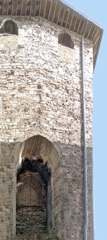
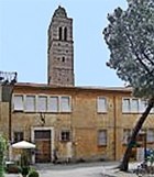
Continue to the so-called Torre dei Vitelleschi at the end of the street, which originally formed part of the walls of ca. 1240. The remains of the Porta San Constantii (also known as the Porta Vetus Contrastanghe), a gate in the city walls of ca. 1240, are still clearly visible at the base of the tower (to the right in the photograph above). Continue through the arch to the right of the tower, in to Corso Cavour: the line of the walls continued along Via del Gonfalone, opposite.
Return to and continue along Corso Cavour. Most of the block on the right (numbers 72-98) belonged to the Abbazia di Sassovivo from the 11th century: it housed
-
✴a palace that, in the period 1864-8, housed the important publishing company of Pietro Sgariglia (whose arms can be seen at numbers 74 and 94);
-
✴an inn; and
-
✴the church of San Giorgio. The rim of the rose window of this church can be seen at number 90-2 (to the left in the photograph above).
The inscription at number 123-35 records that Giuseppe Garibaldi stayed here in December 1848.
Turn left here and immediately right into Piazzetta del Suffragio, which is to the side of the church. This small square used to be called the Piazzetta della Croce, which referred to a Crucifix in a tabernacle that was demolished in 1861.
Turn left as you leave the oratory, along Via dell’ Annunziata, and then right into the Piazza della Repubblica, where the walk ends.
Return to the home page on Walks in Foligno.