
Ancient Ikuvina/ Iguvium
The Iguvine Tables mention three city gates: Trebulana, Tessenaca and Vehia, and this obviously implies a circuit of ancient city walls. The scant archeological evidence for this circuit suggests that this circuit was restored or rebuilt under Roman influence in the 2nd century BC.
It seems likely that:
-
✴Porta Tessenaca was in what is now Largo del Bargello, near the 10th century Porta San Giuliano, and opened onto the ancient bridge across the Camignano; and
-
✴Porta Vehia was on or near the site of the present Arco di San Marziale.
These gates were presumably connected by walls that followed the lines of what are now Via dei Consoli and Via XX Settembre, which would have protected the settlement from attack from the plain below.
Paolo Micalizzi (referenced below) showed that the most likely location for the third gate, Porta Trebulana, is higher up the slope of Monte Ingino, perhaps on the site of the medieval Porta Sant’ Agnese (below), which was closed in in ca. 1480, at the time of the construction of Cassero Grande.
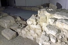
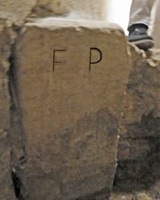
The urban centre expanded in the 2nd century BC into the area below the line of Via dei Consoli and Via XX Settembre, along the left (upper) bank of the Camignano. An ancient brick structure that has been excavated under the Loggia dei Tiratori seems to have been associated with this stream, albeit that its precise function is unclear (city gate, bridge, channelling structure?). A cippus that remains in situ on the right (lower) bank of the Camignano (now in the basement of the Unicredit Banca) contained the inscription (EDR 158581) “F(ines) P(ublici)”, which dates to the period 70 - 30 BC. This suggests that the torrent marked the southern (lower) boundary of the urban settlement at this time. (You can ask at the bank to see this excavated area and the inscription - I have picked out the inscription on the cippus for clarity).
A substantial suburb developed still further into the plain (along Via degli Ortacci and what is now the archeological area) in the following century.
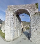
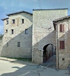
Arco di San Marziale
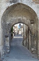
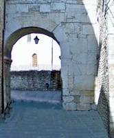
This arch is not in the circuit of the 13th century walls, which suggests that it was instead part of the earlier circuit. It reuses materials from an older gate (2nd century BC) that presumably stood on this site. This older structure might well have represented the monumentalisation of the Ikuvine Porta Vehia (above).
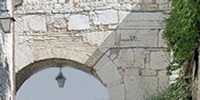
The horizontal layers above the inner arch contain (shown in enlargement above):
-
✴a disc that is reminiscent of those used to decorate Arco Etrusco, Perugia (to the left); and
-
✴an inscription (CIL XI 5821 - to the right) that reads:
TERENTIVS P F VOPISC[VS]
IIIVIR IVR DIC
-
which refers to the Roman magistrate (quattroviri iure dicundo), Terentius son of Publius Vopisus, who was possible responsible for the monumentalisation of the gate.
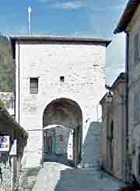
Porta San Giuliano
-
✴in 1182, Pope Lucius III confirmed the “capellam Sancti Iuliani supra portam civitatis positam” as a possession of the canons of the Duomo; and
-
✴at some in the period 1188-94, Bishop Bentivoglio confirmed the rights of the canons over “ecclesiam Sancti Iuliani positam supra murum civitatis Eugubini”.
The Fontana dei Matti (16th century) in Largo del Bargello was documented as “fons iuxta portam sancti Juliani” in 1274.
This is thought to have been the site of the Ikuvine Porta Tessenaca (above), which was probably monumentalised in the Roman period.
-
✴A tract of the Roman wall containing an opening for pedestrians is apparently visible from what are now the premises of the majolica outlet of Maestro Leo Grilli at number 1, Largo del Bargello, the door of which is in the right wall of the church.
-
✴Blocks that were reused in the foundation of the building at 39 Via dei Consoli, at the junction with Largo del Bargello and Via Remosetti may well have come from this wall.
A bridge across the Camignano that is now known as Ponte San Martino (a short distance down Via dei Consoli, behind the point at which this photograph was taken) was certainly in existence in Roman times and perhaps even earlier. [The point of attachment of the Roman bridge can still be seen].
10th Century Walls
Episcopal Complex
The early chronicles of Gubbio record a circuit of walls that existed from at least 921. Some scholars have suggested that this was based on the Umbro-Roman circuit. However, Paolo Micalizzi (referenced below) has deduced that these walls enclosed only a small area around the site of the present church of San Giovanni Battista.
A document of 1096 describes an enclosed complex that included the first Duomo of San Mariano, the Canonica and an associated hospice. Paolo Micalizzi suggests that:
-
✴its upper boundary coincided with the lower part of the ancient circuit (Via dei Consoli and Via XX Settembre);
-
✴its lower boundary was marked by the Camignano; and
-
✴its side boundaries ran along what are now Via Piccardi and Via della Repubblica.
It seems likely that it also included the “plebem ... S. Johannis de civitate” (parish church of St John, which was the predecessor of the current church), which was was documented as a possession of the canons of San Mariano in 1137.
The urban settlement at this time probably extended beyond Via Piccardi, still bounded by the ancient circuit of walls and the Camignano, as far as the site of the Ikuvine Porta Tessenaca (above). The aqueduct (13th century) from the the Gola del Bottaccione seems to have entered the city at this point and to have fed a fountain known as the “fons arenghi” (from “arengo”, which signifies the space used for public meetings)
Porta San Giovanni
A document of 1274 describing the confines of the “Borgo di San Giovanni” records a road that “exit ad portam sancti Johannis et uadit ad directum in flumen” (leaves by Porta San Giovanni and continues to the river). This gate, which is not mentioned in later documents, was probably demolished (like the walls themselves) soon after the document of 1274 was written.
Città Nuova
A second area of urbanisation, the “vicus ultra aquam”, seems to have developed at about this time under the auspices of the local nobility, on the lower bank of the Camignano near the Gola del Bottaccione. This area seems to have been fortified and to have had three gates:
-
✴Porta Metauro (below), which is named for the Metauro Valley and Urvinum Metaurense, the Roman name for Urbino;
-
✴Porta Castello (below); and
-
✴a third gate that probably opened onto the ancient bridge across the Camignano.
12th Century Walls
New Civic Centre
The events that were to lead to a dramatic change in the development of city probably began with the fire of 1126, which devastated much the existing urban fabric, including the old Duomo. A donation in 1141 suggests that efforts were made to restore the latter, but it seems that both the episcopal and civic authorities began to think at this time in terms of expanding the urban area to include the higher slopes of Monte Ingino.
There is evidence that the construction of a new city wall in this are began in the late 12th century. For example, the legend of St Ubaldus has him in dispute in ca. 1160 with the builders of the new city wall near Porta Sant’ Angelo (later Porta Sant’ Ubaldo - below), whose latrines apparently polluted his vineyards.
Bishop Benedetto Bentivoglio seems to have given new impetus to the development of the new ecclesiastical complex:
-
✴In 1188, Pope Clement III gave him permission to translate the relics of the saints of Gubbio (presumably those of SS Marianus and James as well as the body of the future St Ubaldus) from the “antiqua civitate” to the site on the mountain, where the “civitas de novo” had been constructed.
-
✴Shortly thereafter, Bishop Bentivoglio conceded to the canons a new site for their palace “in quo constructum est” (on which was constructed) the new Duomo of SS Mariano e Ubaldo and the episcopal palace.
The diploma (1191) in which the Emperor Henry VI granted important privileges to Gubbio also gave retrospective permission for the construction of the “novam civitatem” on Monte Ingino. The development must have been largely complete by 1203, when a document was agreed “ante ecclesiam ... in platea ubi fit contio” (in front of the cathedral ... in the square in which meetings are held). It is clear that, at least by that time, the new city housed to civic as well as the ecclesiastical authorities: another document of 1203 was notarised “sub tracandam palatii communis Eugubini” ( under the covered loggia of Palazzo Comunale of Gubbio). Excavations under Palazzo Ducale have shown that it stands on the site of this earlier public palace, and that the nearby Palazzo della Guardia was converted to form part of it.
Both the civic and ecclesiastical buildings opened onto the new “platea communis”, which was bounded by the new city wall and a gate, the Porta Sant’ Agnese (named for the nunnery outside the walls). As noted above, this gate, which stood on or near the site of the Ikuvine Porta Trebulana, was closed in ca. 1480.
13th Century Walls
The next phase of urban expansion probably occurred in ca. 1234, when Gubbio consolidated its expansion into the Marches with the formation of the new “colony” of Pergola. It probably began with the development of land that mostly belonged to the Abbazia di San Pietro, below what is now Via XX Settembre.
The administrative districts of the city were rationalised into four “quartieri” towards the end of the century. Each was named for a church at its periphery: proceeding clockwise:
-
✴San Martino, the area above what is now Via dei Consoli, which included the “vicus ultra aquam” and the original Palazzo Comunale;
-
✴Sant’ Andrea, the area above what is now Via XX Settembre, which included the Duomo;
-
✴San Pietro, the area below what is now Via XX Settembre, which obviously included the Abbazia di San Pietro; and
-
✴San Giuliano, the area below what is now Via dei Consoli.
In 1302, Cardinal Napoleone Orsini warned the bishop of Gubbio that the building of the nearby city walls should not compromise the complex of Sant’ Agostino (outside Porta Romana - see below).
Two earlier sections of walls:
-
✴those that had been built around the outer part of the “vicus ultra aquam” in the 1oth century; and
-
✴those that had been built above the “platea communis” in the 12th century;
were extended in a clockwise direction, apparently in two phases:
-
✴along the Caverello torrent and around the Abbazia di San Pietro as far as the Camignano torrent in what is now Largo di Porta Marmorea; and subsequently
-
✴around the Convento di San Francesco to meet the 10th century walls at Porta Castello.
The resulting circuit was some 3 km in length.
Documents suggest that there were twelve gates in this circuit in the 13th century, of which six survive:
-
✴Porta Castello (above);
-
✴Porta Metauro (below);
-
✴Porta di San Ubaldo (or Porta dell’ Angelo);
-
✴Porta Romana (below);
-
✴the double gate of Porta di San Pietro and Porta Vittoria (below); and
-
✴Porta degli Ortacci.
A seventh gate, Porta Marmorea, for which Largo di Porta Marmorea is named, was demolished in 1863, together with a long stretch of walls to the sides of it, to make way for junction of the roads to Perugia and Ancona (Via Perugina and Via Giacomo Matteotti).
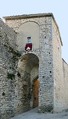
Porta Romana (14th century)
There are two interesting features visible from inside the city:
-
✴an upper arch, which was closed in the 17th century; and
-
✴a ruined fresco of the Madonna and Child with saints and angels above the furthermost arch.
The tower was restored in 1994 and now houses the Museo della Maioliche a Lustro.
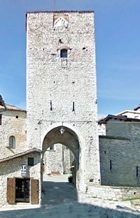
Porta San Pietro
This is the only gate of Gubbio that still has and ante-porte: the lower, outer gate is known as Porta Vittoria.
The gate was restored and fortified in 1378.
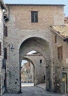
Porta Metauro
Porta Castello
Read more:
P. Micalizzi, ”Storia dell’ Architettura e della Città”, (2009) Gubbio
Return to Monuments of Gubbio.
Return to Walk I (ancient and 10th century elements) or
Walk II (13th century walls)