

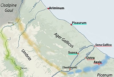
Territory of the Senones
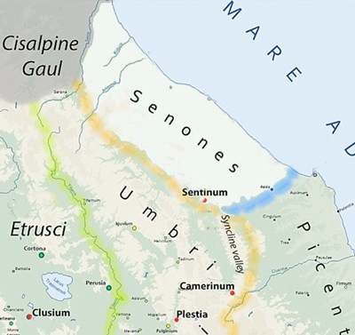
In the 5th and early 4th centuries BC, a number of Gallic tribes settled in the territory of northern Italy that the Romans knew as Cisalpine Gaul, which was bounded by the Alps, the Apennines and the Tyrrhenian and Adriatic coasts. According to Gareth Sampson (referenced below, at p. 36):
-
“The last tribe to migrate across the Alps seems to have been the Senones, who pushed deeper into Italy than [the earlier immigrants] and settled to the east of the Apennines, between the mountains and the [Adriatic] coast.”
Battle of Sentinum (295 BC)
The decisive battle of the Third Samnite War, which took place in 295 BC in agrum Sentinatem (in the territory of Sentinum, near modern Sassoferrato), on the southern border of the territory of Senones. Polybius described a setback that the Romans suffered shortly before their victory:
-
“... the Samnites and Gauls made a league, gave the Romans battle in the neighbourhood of Camerinum [Camerino] and slew a large number [of them]. Incensed at this defeat, the Romans marched out a few days afterwards, and with two consular armies engaged the enemy in the territory of Sentinum; and, having killed the greater number of them, forced the survivors to retreat in hot haste, each to his own land”, (‘Histories’, 2:19).
Livy (having apologised for problems with his various sources) provided a more extensive, although probably less accurate, account of the initial Roman setback:
-
“... before the consuls [Quintus Fabius Maximus Rullianus and Publius Decius Mus] arrived in Etruria, the Senonian Gauls came in a vast body to [Etruscan] Clusium [(Chiusi), in order] to attack the Roman legion and the camp ... :
-
✴Some writers say that the whole [of the Roman army was defeated], so that not one [man] survived to give an account of [the defeat]: thus, no information of [it] reached the consuls, who were [approaching] Clusium, until the Gallic horsemen came within sight, carrying the heads of the slain ... and expressing their triumph in songs according to their custom.
-
✴Others affirm, that the defeat was by Umbrians, not Gauls,... that the loss sustained was not so great. ... [and] that the Umbrians, initially victorious, were [subsequently] defeated ...
-
But it is more probable that this blow was suffered from a Gallic than an Umbrian enemy ...”, (‘History of Rome’, 10: 26; 7-13).
This engagement more probably occurred at Camerinum (as Polybius reported), since at least some of Livy’s sources thought that it had been an Umbrian victory. If so, then the Roman army would probably have approached Camerinum using the Apennine pass at Plestia (near modern Colfiorito). Having recovered from their defeat there, they would have marched through the syncline valley from Camerinum to Sentinum (see the map above). Thus, Livy:
-
“... the consuls [Fabius and Decius] descended into the territory of Sentinum and fixed their camp about 4 miles distance from the enemy ... : the Gauls were [allied] with the Samnites, the Umbrians with the Etrurians.” (‘History of Rome’, 10: 27; 1-3).
The strategist Frontinus (who wrote in the 1st century AD) was much impressed by the Roman battle plan:
-
“In [295 BC], the Gauls, Umbrians, Etruscans, and Samnites had formed an alliance against the Roman people. Against these tribes Fabius first constructed a fortified camp beyond the Apennines in the region of Sentinum. Then, he [arranged for a diversionary Roman attack] on Clusium, ... [as a result of which] the Etruscans and Umbrians withdrew to defend their own possessions, while Fabius and his colleague Decius attacked and defeated the remaining forces of Samnites and Gauls”, (‘Stratagems’, 8:3).
Despite this clever strategy, the outcome of the battle was not a foregone conclusion. At one point, Decius Mus led his men in a disastrous charge against the Gallic cavalry and, when he could not stop them from falling back in disarray, he decided to follow the example of his eponymous ancestor, the consul of 340 BC, and make a ritual self-sacrifice (devotio) in order to turn the tide of battle. According to Livy:.
-
“After the usual prayers had been recited, [Decius] uttered the following awful curse: ‘I carry before me terror and rout and carnage and blood and the wrath of all the gods, those above and those below. I will infect the standards, the armour, the weapons of the enemy with dire and manifold death, the place of my destruction shall also witness that of the Gauls and Samnites.‘ After uttering this imprecation on himself and on the enemy, he spurred his horse against that part of the Gaulish line where they were most densely massed and, leaping into it, was slain by their missiles”, (‘Roman History’, 10: 28: 16).
This act apparently had the effect that Decius had intended. Meanwhile:
-
“Fabius, on hearing of his colleague's death, ordered a [an attack on the Gallic rear.] He also vowed a temple and the spoils of the enemy to Jupiter Victor, and then proceeded to the Samnite camp, to which the whole crowd of panic-struck fugitives was being drive. As they could not all get through the gates, those outside tried to resist the Roman attack and a battle began close under the rampart. It was here that Gellius Egnatius, the captain-general of the Samnites, fell. Finally the Samnites were driven within their lines and the camp was taken after a brief struggle. At the same time the Gauls were attacked in the rear and overpowered; 25,000 of the enemy were killed in that day's fighting and 8000 made prisoners. ... After sending out a search party to find his colleague's body, Fabius had the spoils of the enemy collected into a heap and burnt as a sacrifice to Jupiter Victor. ... [Decius’ body] was discovered the next day and brought back to camp amidst the tears of the soldiers. Fabius laid aside all other business in order to pay the last rites to his dead colleague; the obsequies were conducted with every mark of honour and the funeral oration sounded the well-deserved praises of the deceased consul”, (‘Roman History’, 10: 29: 10-20).
This was the decisive battle of the war: as the Fasti Triumphales recorded, Fabius was awarded a triumph over the Samnites, Etruscans and Gauls.
After their victory at Sentinum, the Romans seemed to have concentrated on finishing off the Samnites, which they duly did in 290 BC. This was followed in the same year by their dramatic conquest of the Sabines, whose territory was to the south of that of the Picentes. Thereafter, as Gareth Sampson (referenced below, at p. 44) observed:
-
“... the focus shifted back onto ... the Gauls of northern Italy and, in particular, onto the Senones ...”
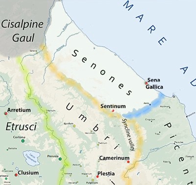
Conquest of the Senones (283 BC)
The Gauls seem to have presented the Romans with a causus belli in 284 BC, when, according to Polybius, they laid siege to the Etruscan city of Arretium (Arezzo):
-
“... the Romans went to the assistance of the [besieged] city and were beaten in an engagement under its walls. [Since] the praetor Lucius [Caecilius] had fallen in this battle, Manius Curius [Dentatus] was appointed in his place. The ambassadors whom he sent to the Gauls to treat for the prisoners were treacherously murdered ... At this, the Romans, in high wrath, sent an expedition against them, which was met by the tribe called the Senones. In a pitched battle, the army of the Senones was cut to pieces. The rest of the tribe was expelled from the county, into which the Romans sent the first colony that they ever planted in Gaul: namely, ... Sena [Gallica], so called from the tribe of Gauls that had formerly occupied it”, (‘Histories’, 2: 19).
Appian, recorded that, by besieging Arretium, the Senones had violated an existing treaty with the Romans, which had possibly been agreed after the Battle of Sentinum (above). He also attributed the conquest of their territory primarily to Publius Cornelius Dolabella, one of the consuls of 283 BC:
-
“The Senones, although they had a treaty with the Romans, nevertheless furnished mercenaries against them, wherefore the Senate sent an embassy to them to remonstrate against this infraction ... Britomaris, the Gaul, being incensed against them on account of his father, who had been killed by the Romans while fighting on the side of the Etruscans in this very war, slew the ambassadors ... . He then cut their bodies in small pieces and scattered them in the fields. The consul Cornelius, learning of this abominable deed while he was on the march, moved with great speed against the towns of the Senones by way of the Sabine country and Picenum, and ravaged them all with fire and sword. He reduced the women and children to slavery, killed all the adult males without exception, devastated the country in every possible way, and made it uninhabitable for anybody else. He carried off Britomaris alone as a prisoner for torture. A little later the Senones (who were serving as mercenaries), having no longer any homes to return to, fell boldly upon the [other] consul Domitius, and being defeated by him killed themselves in despair”, (‘Gallic History’, 11).
Most scholars follow William Harris (referenced below, at p. 80) in assuming that Appian’s attribution of this victory to Dolabella was:
-
“... simply a confusion with the battle of Vadimon [in the following year].”
On this occasion, according to Polybius:
-
“Seeing the expulsion of the Senones, and fearing the the same fate for themselves, the Boii made a general levy, summoned the Etruscans to join them, and set out to war. They mustered their forces near the lacus Vadimonis, and there gave the Romans battle; in which the Etruscans indeed suffered a loss of more than half their men, while scarcely any of the Boii escaped. But yet, in the very next year, the same two nations joined forces once more; and ... gave the Romans battle again; and it was not until they had been utterly defeated in this engagement that they humbled themselves so far as to send ambassadors to Rome and make a treaty, (‘Histories’, 2: 20).
It seems then that the Romans devastated and depopulated the territory of the Senones in 283 BC. They did not, however, destroy all traces of Gallic culture: as Saskia Roselaar (referenced below, 2010, at p. 72, note 196) observed:
-
“... it has been suggested that the Senones were not all ejected from their lands [and that] there are strong influences of [their] culture [in the surviving archeological record] after the date of their supposed ejection ... That does not mean that their land cannot have been made ager publicus: in fact, it often happened that land was made ager publicus without the previous inhabitants being driven off [it].”
Nevertheless, the erstwhile territory of the Senones was subsequently known as the Roman ager Gallicus.
Settlement of Ager Gallicus (283 - 232 BC)
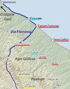
Adapted from the Digital Atlas of the Roman Empire
Via Flaminia: route documented from ca. 7 BC
Citizen Colonies: Sena Gallica (283 BC); Pisaurum (184 BC)
Aesis is sometimes characterised as a citizen colony founded in 247 BC but this is unlikely (see below)
Underlining indicates tribal assignation: red = Pollia; turquoise = Camilia; Yellow = Lemonia
(The Latin colony of Ariminum (268 BC), which was not formally within the ager Gallicus, was assigned to the Aniensis tribe after the Social Wars)
There is no surviving record of the precise boundaries of the ager Gallicus: for example, as Simone Sisani (referenced below, 2007, at p. 68) pointed out, the Augustan sixth region of Italy, as recorded by Pliny the Elder (‘Natural History’, 3:19):
-
“... embraced two distinct [cultural and ethnic] realities, Umbria and the ager Gallicus, the respective boundaries of which are not explicitly attested in the [surviving] sources” (my translation)
He deduced (at p, 72) on the basis of archeological evidence of pre-Roman Gallic culture that the ager Gallicus comprised:
-
“... the future centres of:
-
✴Sena Gallica (Senagallia), Fanum Fortunae (Fano) and Pisaurum (Pesaro), on the coast; and
-
✴Sentinum, Aesis (Jesi), Ostra, Suasa and Forum Sempronii (Fossombrone) in the interior” (my translation).
As we shall see, the Latin colony of Ariminum, which was founded in 268 BC, had been founded on land confiscated from the Gallic Boii: it seems to me that this territory too must have formed part of the ager Gallicus for a period after 283 BC. By the time of Pliny the Elder (‘Natural History’, 3:20), it marked the southernmost point of the eighth region, which extended along to Po valley, embracing what had been the territory of the Boii.
Historical Context for Viritane Settlement
Aftermath of the Conquest
As noted above, much if not all of the ager Gallicus was available for citizen settlement after the conquest. Some light can be thrown on the extent of its initial distribution by considering the surviving archeological evidence and the pattern of tribal assignations that developed over time (conveniently documented by Simona Antolini and Silvia Marengo, referenced below).
Colonisation before 232 BC
Sena Gallica (283 BC)
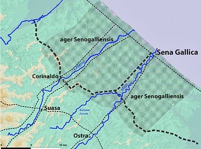
Territory of Sena Gallica
Adapted from G. Lepore (referenced below, p. 229, figure 5)
Dotted line represent the road network
Livy recorded that, in the period 290-87 BC:
-
“Colonies were founded at Castrum [Novum], Sena [Gallica] and Hadria”, (‘Periochae’, 11: 7).
While this is probably accurate in respect of Castrum Novum and Hadria (both in Picenum and discussed on the previous page), it seems to me to be unlikely that the Romans could have founded the colony of Sena Gallica at this point, when the land in question was still occupied by the Senones. In my view, we should probably instead follow Polybius (above), who reported that, immediately after the conquest of 283 BC:
-
“... the Romans sent the first colony that they ever planted in Gaul: namely, ... Sena [Gallica], so called from the tribe of Gauls which formerly occupied it”, (‘Histories’, 2: 19).
The new colony was founded on the coast, near the mouth of the Misa river. Livy (‘History of Rome’, 27: 38: 4) listed it among 7 maritime citizen colonies that, in 207 BC, pleaded their exemption from prolonged military duties elsewhere. It is often asserted that only 300 citizen settlers were enrolled for this type of colony, and that this was therefore the case at Sena Gallica. However, the number of colonists is known for only 6 of about 20 known maritime colonies:
-
✴Tarracina, which also appears in Livy’s list of 207 BC; and
-
✴5 founded in 194 BC (Livy, ‘History of Rome’, 32: 29: 3).
It is true that the number of colonists in each of these 6 was 300. However this does not prove that this applied at Sena Gallica: as Giuseppe Lepore (referenced below, in the English abstract) pointed out, excavations at Sena Gallica suggest that this:
-
“... first [maritime colony] on the Adriatic [it had] the shape and size of a [Latin colony], recalling the situation that, 20 years later, characterised the [Latin] colony of Ariminum. The new [evidence gained from the excavations] allows us to hypothesis that Rome adopted a new form of [citizen colony as part of] its ‘Adriatic policy’.”
In the body of his paper (at pp pp. 231-2), he expanded as follows:
-
“We can recognise [from the new archeological data] a city of dimensions quite unlike those of other maritime colonies: we are looking at [an area of some] 18 hectares, compared with 2-2.5 hectares for the older maritime colonies on the Tyrhenian coast” (my translation).
He suggested that this new model had also applied at the citizen maritime colony of Castrum Novum, which had been founded to the south (on land recently confiscated from the Praetutti) at about the same time and which had an estimated area of some 10 hectares.
Graham Mason (referenced below, at p. 82) observed that:
-
“There is no specific evidence for the level of prosperity [of the Sena Gallica], except that it became an established place often mentioned [in the surviving sources]. It was adjacent to a broad alluvial plain and a coastal lagoon, and was too distant to be provisioned from Rome as would have been necessary unless the colonists provided for themselves.”
Giuseppe Lepore (referenced below, at p. 231) identified
-
“... the presence of a vast [centuriated territory] that was very probably associated with the city from its foundation. [which] seems to testify, already in the 3rd century BC, to the function of the settlement and the agricultural exploitation of the new territories, which had only recently become ager publicus populi Romani” (my translation).
It is noteworthy that this centuriated area extended across the upper regions of both the Misa and Cesana rivers, towards the later centres of Ostra and Suasa respectively. Giusepp Lepore noted (at p. 230) that:
-
“Obviously, proposing a precise chronology for a persisting centuriation is practically impossible but, once again. [the results of recent excavations] can give us some insights: [in particular] various materials from the site of [Corinaldo, marked on the map above] ... could be referable to production facilities that pre-dated 232 BC” (my translation).
The citizen colonists at Sena Gallica were assigned to the old rural Pollia tribe, as evidenced by AE 1981, 334 (1st century BC). As Simone Sisani (referenced below, 2007, at p. 217) observed, this must have been the first voting tribe established in this area. It was one of the old rural tribes, and this is the earliest known example of its extension away from its original heartland.
Sena Gallica was documented in the context of Hasdrubal’s invasion of Italy in 207 BC, which culminated in the Battle of the Metaurus (discussed below). However, as Giuseppe Lepore (referenced below, at pp. 234-5) pointed out, it subsequently:
-
“... seems to have disappeared from history, except for the moment of its (probable) destruction [in 82 BC] during the civil war ... For the ancient colony, ... we have only very few traces of public buildings and epigraphic material from the imperial period. The image that seems to emerge is that of an urban centre that was only sparsely populated after the Republican period, with rather simple buildings ... There is no evidence of the prestigious buildings that characterise the public areas of Roman cities [and] no indication to date of a forum and its associated buildings” (my translation).
He speculated (at pp. 233-4) that:
-
“Only 20 years after the foundation of Sena Gallica, the changed political and strategic situation showed how the site of [the new coastal Latin colony of] Ariminum [below] was more suitable to serve as the headquarters for the advance to the north: obviously, the city of Sena Gallica was not abandoned, but the ‘public investment’ in it must have decreased considerably, as demonstrated by the fact that, in 220 BC, the new Via Flaminia avoided the Misa valley and instead privileged the valley of the Metaurus and the more northerly route that better connected to Ariminum” (my translation).
However, as I discussed below, it is at least possible that, in 220 BC, Via Flaminia followed the ancient route along the Misa valley to Sena Gallica, before turning along the coast towards Pisaurum and Ariminum. (Indeed, as I mention below, this might explain why the Roman general Livius Salinator established his camp near Sena Gallica in 207 BC in order to block Hasdrubal’s advance into Umbria).
In other words, while it is certainly likely that Sena Gallica received much less ‘public investment’ than Ariminum after 268 BC, it probably still retained some strategic importance, at least in the period 220- 207 BC. I suggest below that it would have been eclipsed in 184 BC, when a new citizen colony was established at Pisaurum, some 30 km to the north. It might have been at this point that Via Flaminia was re-routed to cross the Apeninnes via the Gola del Furlo and continue towards the coast along the Metaurus valley.
Ariminum (268 BC)
According to Velleius Paterculus:
-
“... in the consulship of [Publius Sempronius Sophus and Appius Claudius Russus, i.e. 268 BC], colonists were were sent to Ariminum and Beneventum”, (‘History of Rome’, 1: 14: 7).
Livy recorded the same information:
-
“When the Picentes had been subdued, they were given peace. Colonies were founded at Ariminum in Picenum and at Beneventum in Samnium”, (‘Periochae’, 15: 4).
Thus, the colony at Ariminum was founded in 268 BC, immediately after the conquest of Picenum. Gino Bandelli (referenced below, at columns 17-8) observed that this was a Latin colony that would have had some 6,000 settler families.
Stephen Dyson (referenced below, at p. 27) commented on the significance of this for Gallo-Roman relations:
-
“In the wake of the annihilation of the Senones [in 283 BC], peace with [the other Gallic tribes to the north] lasted for nearly 50 years [see below]. However, the Romans were laying the [foundations for their conquest]. The first step was the foundation of the Latin colony of Ariminum in 268 BC, [on a coastal site] located between the old land of the Senones and that of the Boii. ... In many ways, the foundation was a turning point in Romano-Gallic relations:
-
✴previously, Rome and the largest Gallic tribes had had only indirect frontier contacts; but now
-
✴the Romans moved several thousand settlers into the territory that the Gauls had considered their own for a century.”
As we shall see below, this colony was the focus of anti-Roman activity by the Boii, who claimed that it stood on their territory. However, it proved an effective base from which the Romans conquered the Boii in a series of wars in the period 238 - 191 BC. Thereafter, it is likely that Ariminum was considered as part of the ager Gallicus.
Aesis (??)
Both Gino Bandelli (referenced below, p. 21 and note 62) and Simone Sisani (referenced below, 2007, at p. 55 and note 156) pointed to the evidence of the production of ceramics on a significant scale at Aesis (Jesi) in the middle of the 3rd century BC.
The earliest certain evidence for the status of Aesis is in the form of the inscription (AE 1990, 0328) on the so-called lapis Aesinensis, which dates to the late 1st century BC and which records that the otherwise unknown Marcus Octavius Asiaticus built a road in honour of three colonies : Ancona, Pisaurum and Aesis. There are a number of hypothesis as to the status of Aesis before that time:
-
✴Some scholars believe that it was the (probably citizen) colony of ‘Aefulum’, which, according to Velleius Paterculus (‘History of Rome’, 1: 14: 8), was founded in in 247 BC;
-
✴Simone Sisani (referenced below, 2007, at p. 55) suggested that it was the Forum Essi or Aesi that was recorded in relation to a prodigy of 163 BC by Julius Obsequens; (‘De prodigiis liber’, 14) . He further suggested that Velleius had been led astray by a source that had actually recorded the constitution of this forum in 247 BC.
-
✴Gino Bandelli (referenced below, at columns 22-3) noted the absence of Aesis from the ‘Liber coloniarum’ (which was compiled in the 4th century AD): according to Saskia Roselaar (referenced below, 2009, at p. 199), the two surviving compilations of this name were based on information in a survey commissioned by the Emperor Augustus (27 BC - 14 AD):
-
“The main aim of the survey carried out at this time was most likely to avoid [a repetition of the] confiscation and violence that had occurred in the triumviral period. To this end, Augustus gathered information on land settlement from the Gracchi [i.e. from ca. 133 BC] until his own period, and organised these by region.”
-
Bandelli pointed out (at column 23) that, assuming that this list is complete, then the colony of Aesis mentioned on the lapis Aesinensis (see below) must have been founded before ca. 133 BC. He suggested that it might well have been founded earlier in the 2nd century.
I discuss these hypotheses as a postscript below. However, in my view, all we can really say about its status over time is that:
-
✴the archeological evidence mentioned above suggests that Aesis was settled (whether by colonists or viritane settlers) before the lex Flaminia agraria of 232 BC; and
-
✴it was certainly a colony by the late 1st century BC.
It is not possible to be certain about its status prior to colonisation:all we know is that it was assigned to the Pollia (see below), either on or prior to colonisation.
Viritane Settlement before 232 BC
Trial assignations, following Simona Antolini and Silvia Marengo (referenced below)
Underlining: turquoise = Camilia; red = Pollia
From 283 BC, the newly-designated ager Gallicus was border country, albeit that it was protected to some extent by the foundation of the Latin colony of Ariminum in 268 BC. We know from later events (discussed below) that the presence of Ariminum was greatly resented by the Gallic tribes of Cisalpine Gaul. However, for whatever reason, we have no record of any significant security problems until 238 BC (discussed below). Thus we can reasonably assume that this period must have seen at least some viritane citizen settlement on the confiscated land before the lex Flaminia agraria of 232 BC.
Aesis
As noted above, there is archeological evidence for settlement of some kind at Aesis from at least the middle of the 3rd century BC, and the centre was assigned at some point to the Pollia (the tribe of the citizen colony at Sena Gallica, founded in 283 BC). According Lily Ross Taylor (referenced below, at p. 89), from the 3rd century BC, existing tribes in many places were extended into contiguous territories that received citizen settlers. Furthermore, as she observed (at p. 90):
-
“... the tribe that received by far the greatest extension [of this kind] was the Pollia. From [at least] the settlements under [the lex Flaminia agraria] of 232 BC, there developed [in the ager Gallicus] communities in the Pollia ... After this [legislation], the Pollia became accepted as the tribe to which [settlers in ] the ager Gallicus were enrolled.”
She then described the further extension of this tribe across Cisalpine Gaul and Liguria as these territories were also progressively incorporated into the Roman state. Thus the tribal assignation of Aesis to the Pollia is unsurprising, irrespective of the date at which it occurred. In fact, only three centres in the ager Gallicus were assigned to a tribe other than the Pollia:
-
✴Sentinum, which was assigned to the Lemonia, as discussed in a later section; and
-
✴Pisaurum and Suasa, both of which were assigned to the Camilia (discussed below).
Ostra
According to Lily Ross Taylor (referenced below, at p. 90):
-
“From the settlements under [the lex Flaminia agraria] of 232 BC, there developed [in the ager Gallicus] communities in the Pollia [at]: Fanum Fortunae; Forum Sempronii; and Ostra.”
I discuss the likely timing of the viritane settlement of Fanum Fortunae and Forum Sempronii below. However, in the present section, I would like to suggest that the viritane settlement at Ostra might well have pre-dated the lex Flaminia agraria.
Unfortunately, there is almost no archeological evidence from Ostra to date that throws light on the matter: the only potentially relevant item here is the Etruscan graffiti ‘θve’ on a fragment of an earthenware vessel from a dwelling that, according to Simone Sisani (referenced below, 2007, at p. 190) was produced locally. He observed that it:
-
“... is realised in an alphabet of ‘square’ capitals that was commonly used between the late 4th and the mid 3rd centuries BC, and in no case extending beyond the start of the 2nd century BC” (my translation).
He asserted (citing Giovanni Colonna) that the presence of a locally-produced domestic item carrying this inscription is:
-
“... likely to be interpreted in the context of the movement of people [to the ager Gallicus] following the [lex Flaminia agraria]” (my translation).
However, it seem to me that we cannot rule out the possibility that an Etruscan manufacturer had established a presence in the vicinity at an earlier period: one is reminded of the earlier production facility at Corinaldo, on the edge of the territory of Sena Gallica (see the map above), albeit that there is no evidence there of an Etruscan presence there.
Pier Luigi dall’ Angelo (referenced below, 2008, at p. 85) pointed out that Ostra, which was located in the Misa valley, was also directly connected by an ancient road to Suasa. Furthermore, it is clear from this map that, like Suasa, Ostra is likely to have had close links with Sena Gallica: indeed the road along the Misa valley that connected it to Sena Gallica would have been particularly important after 283 BC Given this topography, it is hard to see why the area around Ostra would have been settled at a later date than the area around Suasa, which, as we shall see, may well have received Roman viritane settlers soon after the conquest). If so, then these settlers would have been assigned to the Pollia, which was the tribe of Ostra itself from 49 BC.
Suasa
Pier Luigi dall’ Angelo (referenced below, 2008, at p. 85) pointed out that Suasa was located in the Cesena valley, on an ancient route that connected Sentinum to the coast and would have been particularly important before the construction of Via Flaminia (see below). According to Enrico Giorgi (referenced below, at p. 346), recent excavations here unearthed remains from ca. 300 BC (below those of the so-called Edificio di Oceano). Simone Sisani (referenced below, 2007, pp. 191-8) also provided extensive evidence of the early settlement, including finds from an important necropolis and sanctuary that have been excavated at Arcevia, some 12 km south of Suasa (with which it shares the Cesena valley). Sisani suggested that:
-
✴“... the tombs from the 3rd and 2nd centuries BC could have belonged to Roman viriane settlers after the extermination of the local population” (my translation from p. 196); and
-
✴“The sanctuary, after its Italic phase of the 6th-5th centuries BC, was revitalised in the course of the 3rd century BC ... The absence of evidence for the 4th century BC coincides perfectly with the period of Gallic use of the necropolis. The periods of the use of the sanctuary therefore testify to a profound cultural change that can be placed in the early 3rd century BC, which the literary sources allow us to identify with the massacre of the Senones in 283 BC” (my translation from p. 197).
Pisaurum
As noted above, a citizen colony was founded at Pisaurum in 184 BC. There is no secure evidence of an urban settlement here before the foundation of the colony, but some scholars hypothesise the presence of Roman and Latin settlers in the area, perhaps from268 BC, when the colony of Ariminum was founded. This is based on the evidence of the votive remains (including 14 inscribed votive altars) that were found in the 18th century on what was probably the site of an ancient sacred grove (now known as the lucus Pisaurensis) at Santa Veneranda, some 5 km inland from modern Pesaro.
Early Prefectures in the Ager Gallicus?
On the basis of the discussion above, we might reasonably assume that, soon after the conquest:
-
✴Manius Curius Dentatus sponsored viritane settlement at Pisaurum and Suasa, assigning the settlers to the Camilia; and
-
✴another programme of organised settlement took place at Aesis and Ostra, where the settlers were assigned (like the colonists at Sena Gallica) to the Pollia.
There is no surviving evidence for the administrative framework of these settled areas. However, we might look at the broadly contemporary settlement of the territory of the Praetutti, on the border between Picenum and the alta Sabina (discussed in my page on ‘Prefectures: Sabina and Picenum’):
-
✴As noted above, a citizen colony, Castrum Novum, was founded on the coast here at broadly the same time as that at Sena Galica.
-
✴The name of a nearby settlement, Interamnia Praetuttiorum suggests a Roman settlement that functioned as an administrative centre for viritane settlers on land that (like the land at Castrum Novum) had been confiscated from the Praetutti. Importantly, we know from Frontinus that:
-
“... Interamnia Praetuttiorum ... is said to have been a conciliabulum and later granted the status of a municipium” (‘Land Disputes’, reproduced and translated into English by Brian Campbell (referenced below, at pp. 6-7).
-
It could have been so-constituted at any time after 290 BC, albeit that the inhabitants of the centre itself and the surrounding territory could not have been assigned to the Velina before 241 BC (the year in which this tribe was first organised).
By analogy, any (or all) of Aesis, Ostra, Pisaurum and Suasa could have been constituted as a conciliabulum (official meeting place) for the viritane settlers around Sena Gallica.
More importantly for our purposes, many scholars assume that Interamnia Praetuttiorum was also the seat of a Roman prefect, albeit that the surviving evidence for prefectures along the Adriatic coast related only to Picenum (discussed in my page on ‘Prefectures: Sabina and Picenum’):
-
✴a reference by Julius Caesar in 49 BC to the prefectures of Picenum; and
-
✴a specific mention by Cicero of the prefecture of the Picene centre of Cingulum.
A similar assumption is often made in relation to the nucleated centres of the ager Gallicus. Thus, for example, Pier Luigi Dall’Aglio and Sandro De Maria (referenced below, 2010, at pp. 40-1) asserted that:
-
“... almost all of the 36 urban centres that can be identified from the description by Pliny the Elder of the [Augustan 5th and 6th regions of Italy] had evolved during the 1st century BC from the many of the praefecturae that had been associated with viritane assignments. Since these praefecturae were essentially service centres for [these] settlers ..., they had to be located along the various routes of traffic or ... [at least] in easily reachable locations connected to the Roman road network. The consequence is that, within each individual valley system [between the mountains and the Adriatic], ... we normally find a city at the mouth of the river, where there is the interchange between ... terrestrial and maritime traffic .... In [the ager Gallicus], this is the case for [at least] two cities ... : Suasa and Ostra, located [respectively] in the Cesano ... and Misa valleys” (my translation).
As discussed below, it is often assumed that the constitution of prefectures in the ager Gallicus post-dated the lex Flaminia agraria. However, given the evidence discussed here for viritane settlement before that date, there is no obvious basis for this timing. It seems to me that any (or all) of Aesis, Ostra, Pisaurum and Suasa could have been the seat of a Roman prefect even before 232 BC, albeit that the evidence that any of them ever had this function is purely circumstantial.
War with the Boii (238-6 BC)
As set out above, the surviving evidence for viritane settlement in the ager Gallicus prior to 232 BC is confined to the coastal site at Pisaurum and the area to the south of it, around Sena Gallica. It is, of course, possible that this simply reflects deficiencies in the archeological record. However, it is also possible that the Roman authorities found it difficult to attract settlers to the ager publicus closer to Cisalpine Gaul. If so, then any such reluctance on the part of potential settlers would have been vindicated by the events of 238 BC, when the Boii, who seem to have been quiescent since the conquest of the Senones, returned to the fray at the head of a Gallic alliance.
The reasons for the timing of the revolt are obscure. However, it seems from the sparse information in the surviving sources that the Romans were not well-prepared for it, so something must have provoked the Gauls into action. Roman fortunes oscillated in the first two years of the confrontation, which must have instilled a sense of insecurity among the settlers in the ager Gallicus. Thereafter, however, the Boii apparently lost control of the situation: according to Zonarus, in his epitome of a lost book by Cassius Dio:
-
“When confronted by [the new consuls of 236 BC, Publius Cornelius Lentulus Caudinus and Quintus Licinius Varus, the Boii] hoped to terrify them by their numbers and prevail without a battle. So they sent [envoys to them, who] demanded back the land surrounding Ariminum and commanded the Romans to vacate the city, since it belonged to them. The consuls, because of the small number [of their soldiers], did not dare to risk a battle: [however,] nor would they undertake to abandon any territory. Accordingly, they arranged an armistice, to enable the Gauls to send envoys to Rome. These came before the Senate with the same demands, but obtained no satisfaction, and returned to their camp. There, they found their cause was lost: some of their allies had repented and, regarding the Romans with fear, had turned upon the Boii, and many were killed on both sides. Thereupon the remainder went home, and the Boii obtained peace [from Rome only] at the price of a large portion of their land” (‘Epitome’, 8:18).
Thus, the Romans gained further territory that would have served as a buffer zone, but only because of the collapse of the Gallic alliance. However, whether from a new sense of security or alternatively from a renewed impetus for the Romanisation of the ager Gallicus, the Romans began a new programme of viritane settlement there.
Lex Flaminia Agraria (232 BC)
We learn from Polybius that, in 232 BC:
-
“... the Romans divided among their citizens [that part of] the territory of Picenum from which they had ejected the Senones. Caius Flaminius was the originator of this popular [i.e. pro-plebian] policy ... ”, (‘Histories’, 2: 21).
Polybius’ identification of the land to be distributed was confirmed by Cato the Elder: according to Varro, Cato had referred to the excellent wine yield achieved on the land:
-
“... called ager Gallicus Romanus, which was the subject of viritane distribution, [and which extended] from this [i.e. the Roman or southern] side of Ariminum to the territory of the Picentes”(‘Origines’, see paragraph 43 in the fragments assembled by Hermann Peter, my translation).
Although, in a later reference to these events, Cicero (quoted below) referred to Flaminius’ distribution of the agrum Picentem et Gallicum (the Picene and Gallic lands), we might reasonably assume (with, for example, Daniel Gargola, referenced below, at p. 104 and Saskia Roselaar, referenced below, 2010, at p. 315, note 76) that the lex Flaminia agraria applied only to the ager Gallicus.
Rachel Feig Vishnia (reference below, 2012, at pp. 40-1) suggested that, in proposing and enacting this law, Flaminius and his obviously influential supporters (see below) must have been motivated by the belief:
-
“... that the ager Gallicus..., which remained [at least to some extent] uninhabited ... should be settled, in order:
-
✴to provide lands for Roman farmer-soldiers who had lost their lands [presumably largely as a result of their extended military service away from home] - the last large scale land division had been carried out under Curius Dentatus some 50 years earlier and only two Latin colonies had been founded in the recent past: at Brundisium in 244 BC; and at Spoletium in 241 BC; and
-
✴to establish a properly-manned zone on the northeastern border with the Boii ...”
Caius Flaminius and the Lex Flaminia Agraria
Caius Flaminius, who was on his way to becoming the first member of his family to attain the consulate, was still a tribune of the plebs when his agrarian law was enacted. Polybius accused him of two offences in relation to his promotion of what he characterised (apparently pejoratively) as a democratic measure:
-
“... we must pronounce [it] to have been:
-
✴the first step in the demoralisation of the people; as well as
-
✴the cause of the next Gallic war. For many of the Gauls, and especially the Boii ,whose lands were coterminous with the Roman territory, entered upon that war from the conviction that the object of Rome in her wars with them was no longer supremacy and empire over them, but rather their total expulsion and destruction”, (‘Histories’, 2: 21).
In other words, in Polybius’ judgement, Flaminus’ law represented:
-
✴in the manner of its passing, the first step in the ‘demoralisation of the people’, presumably because, in his opinion, it encouraged them to ignore the opinions of their betters; and
-
✴in its enactment, the direct cause of the Gallic War of 225 BC (discussed below).
Cicero (more than a century after Polybius) often repeated the first of these criticisms. For example:
-
“Caius Flaminius, ... when he was tribune of the people, proposed to the people, in a very seditious manner, an agrarian law against the consent of the Senate, and altogether against the will of all the nobles”, (‘De inventione’, 2.52).
Cicero suggested that Flaminius was motivated by a desire to gain popular support:
-
“It is also recorded that Caius Flaminius, who, when tribune of the people, proposed the law for dividing the conquered territories of the Gauls and Piceni among the citizens ... became very popular [among the people] by the mere force of his speaking”, (‘History of Famous Orators’, 57).
However, one wonders whether Flaminius’ actions here were as controversial at the time as these later sources suggest and, more specifically, whether the battle lines were so tightly drawn between the people on one side and the optimates on the other: as Rachel Feig Vishnia (reference below, 2012, at pp. 40-1) pointed out:
-
“It is reasonable to assume that... [Flaminius] did not launch his agrarian law on his own, but was [instead] a member of a group that initiated the law, [which must have included] senior senators. ... [Although Flaminius’] opponents [among the optimates obviously] strongly opposed the law, ... it should be stressed that none of the [surviving] sources specifically states that the Senate eventually voted against it or that Flaminius took it to the people over the Senate's head. ... The law passed and, most probably, a body of 15 land commissioners, which included high ranking senators (and naturally Flaminius as well), was elected [to implement it].”
In the same vein, Daniel Gargola (referenced below, at p. 104) pointed out that Flaminius’ agrarian law was one of three for which we have information in the period 232-173 BC: the other two related to land distribution in (respectively): Apulia and Samnium, in 201 BC; and Liguria and Gaul in 173 BC. He observed that, although the distribution of 232 BC is the only one for which we have an explicit reference to a plebiscite, there is no reason to think that the procedure here differed materially from that followed in the other two cases. He suggested that the later accounts might well have been embellished by hindsight, pointing out that they depict Flaminius:
-
“... in the guise of a typical demagogue ... One act expected from a popular leader [of this kind], especially from those [like Cicero, who were] writing after the reforms of the Gracchi, was the passage of an agrarian law against the will of the Senate ... Despite the rhetorical and political coloration of many of these accounts, the descriptions of the actual provisions of the lex Flaminia agraria [indicate that they were] consistent and reasonable.”
Viritane Settlement after the Lex Flaminia Agraria
As noted above, it seems likely that the following non-colonial citizen settlements in the ager Gallicus had been nucleated before the lex Flaminia agraria of 232 BC:
-
✴Suasa and pre-colonial Pisaurum, both serving settlers assigned to the Camilia; and
-
✴Aesis and possibly Ostra, both serving settlers who were assigned (like the citizen colonists at Sena Gallica) to the Pollia.
We might reasonably assume that these areas saw further settlement after 232 BC .
As noted above, my suggestion that settlement at Ostra pre-dated Flaminius’ law is based on purely circumstantial evidence: many scholars characterise the settlement here and in the territory to the north as a consequence of the law. Thus, for example, Lily Ross Taylor (referenced below, at p. 90):
-
“From the settlements under [the lex Flaminia agraria] of 232 BC, there developed [in the ager Gallicus] communities in the Pollia [at] Fanum Fortunae, Forum Sempronii and Ostra.”
Simone Sisani (referenced below, 2007, at p. 217) expressed the same opinion, although he acknowledged that the archeological evidence for settlement in these three areas is no earlier than ca. 200 BC (as discussed below for the first two and above for Ostra). He made two specific points in favour of his hypothesis:
-
✴“The location of [Fanum Fortunae and Forum Sempronii] on the later route of the Via Flaminia makes obvious the connection between the [putative viritane] settlement here and Flaminius” (my translation).
-
✴“The inclusion of these [two centres and Ostra] in a single tribe, the Pollia, demonstrates that we are dealing with a single initiative identifiable only with the [lex Flaminia agraria of 232 BC]” (my translation).
However, in my view, neither of these two points is beyond argument:
-
✴Peter Wiseman (referenced below, at p. 138) pointed out (in a different context) that
-
“... there is no need road to connect [Flaminius’] road programme [of 220 BC] with [his agrarian law of 232 BC]. The Flaminia was surely built for the transport of armies to the north, not for the convenience of those who had settled in the ager Gallicus.”
-
Furthermore, as I discuss below, it is possible that the Via Flaminia did not take the route through the Gola del Furlo and Forum Sempronia until after the the conquest of the Boii in 191 BC.
-
✴As noted above, the Pollia was the the tribe to which the majority of citizen settlers in the ager Gallicus were assigned from the time of the conquest, apart from the putative early phase of settlement that involved assignation to the Camelia. There is (in my view) no particular reason to believe that all the viritane assignations to the Pollia in the ager Gallicus were associated with Flaminius’ initiative of 232 BC, albeit that this is the only specific settlement initiative for which we have evidence.
In short:
-
✴Ostra might have become a nucleated settlement serving settlers assigned to the Pollia only after 232 BC (as both Ross Taylor and Sisani suggested): if not, it seems likely that, like Aesis, Pisaurum and Suasa, it received additional settlers at this point.
-
✴However, there is, in my view, no basis upon which to assume viritane settlement at either Fanum Fortunae or Forum Sempronii before the 2nd century BC (as discussed further below).
However, the settlement that followed the enactment of Flaminius’ law seems to have been on a significant scale, even if the new settlers were mostly concentrated around existing centres. Polybius was certainly of this opinion, since (as discussed above) he could credibly (if probably unfairly) allege that it provoked a Gallic invasion of Italy some eight years later (see below).
Constitution of Prefectures after the Lex Flaminia Agraria
As noted above, it is usually assumed that, analogously with Picenum, the ager Gallicus was characterised by a number of small nucleated settlements that were constituted as prefectures. Michele Giovanni Silani (referenced below, at pp. 76-7) pointed out that their putative presence in the ager Gallicus is:
-
“... commonly linked to the viritane distributions of the lex Flaminia agraria of 232 BC, which gave rise to the need to manage the [legal affairs of citizen settlers] in these territories, far from Rome. Scholars have associated the [putative] presence of these prefectures [prior to municipalisation] with the duovirale constitutions of the municipalities that were created in both Picenum and the ager Gallicus in the [middle of the] 1st century BC (in contrast to the quattuorviral constitutions normally found in communities that were municipalised in the immediate aftermath of the Social War) ...” (my translation).
On this model, the presence of duoviri in small, non-colonial settlements, which is characteristic of the ager Gallicus, is taken as an indication that the settlements in question:
-
✴were constituted as prefectures following the programme of viritane settlement initiated in 232 BC;
-
✴retained this status after the Social War, when many larger centres became municipia administered by quattuorviri; but
-
✴were reconstituted as municipia administered by duoviri later in the century, from which point the erstwhile role of the Roman prefect was assumed by a local magistrate.
This is a reasonable summary of the received wisdom, but it seems to me that the scant surviving evidence will not support such rigid assumptions. It is certainly reasonable to assume that the presence of Roman citizens in areas such as the ager Gallicus, which were largely rural in nature, required the services of Roman prefects. However, we have no hard evidence to support the assumptions that:
-
✴the practice of sending Roman prefects to the ager Gallicus began only in 232 BC; or
-
✴every settlement administered by duoviri after municipalisation had previously been constituted as a prefecture.
In my view, all we can really say is that any (or all) of Aesis, Ostra, Pisaurum and Suasa could have been the seat of a Roman prefect, if not before 232 BC then soon after.
Gallic War (225-2 AD)
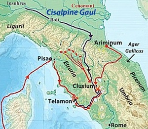
Troop movements leading to the Battle of Telamon (225 BC)
Red= Roman; blue = Gauls
Adapted from the map in this webpage by Karwansaray Publishers
In less than a decade after the renewed settlement of the ager Gallicus, the area was convulsed by a major Gallic invasion. I discuss this war in detail in my page ‘Prefectures : Cisalpine Gaul and Liguria’ (see the link in the boxes at the top and bottom of this page). However, I also describe it in outline here because it must have adversely affected the prospects for the long-term success of Flaminius’ settlement programme.
In or shortly before 225 BC, the Insubres and Boii recruited a number of mercenaries from among the Gallic tribes across the Alps in preparation for the invasion Roman territory. When the threat materialised, one of the serving consuls, Lucius Aemilius Papus, was stationed at Ariminum in anticipation albeit that his colleague, Caius Atilius Regulus, was campaigning in Sardinia. Clearly, the Romans thought that the Gallic army would take the Adriatic route towards Rome. However, the invaders actually crossed the Apennines, marched into Etruria and reached Clusium before the Roman contingent that was supposed to have defended against such a move could catch up with them. Aemilius managed to reach Clusium in time to avert defeat, and the Gauls fell back on the coastal centre of Telamon, with Aemilius in pursuit. Atilius, who had by then landed at Pisae, marched south along the coast to join the fray. The Gauls were comprehensively defeated in this pincer movement, albeit that the consul Atilius was killed in the battle. Thus the Fasti Triumphales record only that Aemilius was awarded a triumph over the Gauls in 225 BC. Polybius observed that:
-
“Thus was the most formidable Gallicic invasion repelled, which had been regarded by all Italians, and especially by the Romans, as a danger of the utmost gravity. The victory inspired the Romans with a hope that they might be able to entirely expel the Gauls from the valley of the Padus [Po]”, (‘Histories’, 2: 31: 8).
In the following three years, the Romans seem to have concentrated on pressing home their advantage:
-
✴The consuls of 224 BC, Quintus Fulvius Flaccus and Titus Manlius Torquatus, marched into Cisalpine Gaul and soon secured the submission of the Boii. According to Arthur Eckstein (referenced below, at p. 15):
-
“Few details of the Boian submission to Rome [in 224 BC] are available to us. Apparently, the consuls exacted an ... absolute surrender and demanded hostages as assurances for future good behaviour. [It was probably at this point that they were] forced to give the Romans certain territory in the northwest corner of their lands for the Latin colony of Placentia [founded in 218 BC]. ... Especially when one considers the leading role of the Boii in the invasion of 225 BC, ... this seems a moderate settlement ... : their freedom of action was somewhat hindered by Roman possession of Boian hostages, but the Boii were still left ... in possession of most of their land.”
-
✴The consuls of 223 BC, Caius Flaminius (the author of the lex Flaminia) and Publius Furius Philus then inflicted a serious defeat on the Insubres in the Po valley: the Fasti Triumphales record that both consuls were awarded triumphs (Flaminius against the Gauls and Furius against both the Gauls and the Ligurians). The Romans, however, remained intent on total submission, and the Insubrians’ request for peace was therefore denied.
-
✴The consuls of 222 BC, Marcus Claudius Marcellus and Cnaeus Cornelius Scipio Calvus, pressed on to total victory. The former secured a decisive victory at Clastidium, during which he personally killed the leader of the opposing army. According to Zonarus, he then rejoined Scipio and:
-
“... they subdued Mediolanum [Milan] and another [unnamed] town. After these had been captured, the rest of the Insubres also made terms with [the consuls], giving them money and a portion of their land”, (‘Epitome’, 8: 20).
-
Arthur Eckstein (referenced below, at p. 15, note 46) suggested that it was at this point that the Romans acquired the land for the Latin colony of Cremona, founded (like Placentia) in 218 BC. He noted (at p. 18) that, more generally, this was a relatively modest settlement, which left the Insubres in possession of most of their land. Marcellus seems to have secured credit for the victory: thus, the Fasti Triumphales record his triumph over the Insubrian Gauls and the ‘Germans’, adding that he brought back the spolia opima after killing the enemy leader, Virdumarus, at Clastidium.
Rachel Feig Vishnia (reference below, 1996, at pp. 23-4) commented:
-
“In 222 BC, after a decisive victory at Clastidium and the capture of Mediolanum, the Insubres’ capital [as described above], the task [of pacifying the Boii and Insubres] was [apparently] completed. Soon after, the Romans installed the symbols of Roman rule in the region:
-
✴in 220-19 BC, the Via Flaminia connecting Rome with Ariminum was constructed; and
-
✴in 219-8 BC, two Latin colonies were founded on land confiscated from the Boii [and the Insubres ?]: Placentia and Cremona, both important river ports situated on strategic sites on the Po.”
I discuss these two developments in successive sections below. First however, I would like to address what followed the quotation above form Rachel Feig Vishnia (at p. 24):
-
“On the eve of the Second Punic War, Rome had just barely begun to consolidate her newly acquired domains. Hannibal’s impressive advance in Spain during 221-20 BC and the growing tensions [there] ... do not seem to have concerned Rome significantly.”
She went on to describe Roman actions in 221-19 BC that were directed against:
-
“... any piratical activity, real or imagined, in the northern Adriatic at a time when Ariminum , the key to Cisalpine Gaul, was becoming an important military and civil harbour and when the coastal part of Via Flaminia ... was being constructed.”
It seems to me that all these actions (the construction of Via Flaminia, the plans to found colonies at Placentia and Cremona, and the campaign to secure the northern Adriatic coast) should more probably be understood as arising now precisely because of growing concerns about the Carthaginian advance in Spain and the consequent threat of an invasion via Cisalpine Gaul.
Via Flaminia (220 BC )
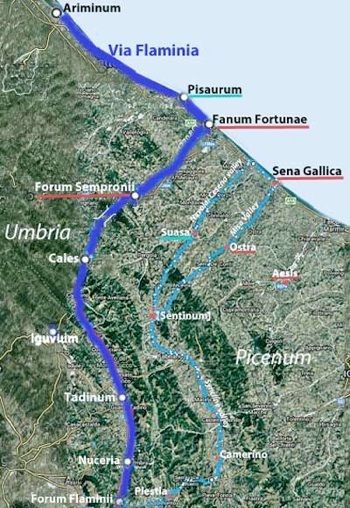
Dark blue: northern section of Via Flaminia via the Gola del Furlo, first documented in ca. 7 BC (Strabo)
Light blue: alternative route from Forum Flaminii to the Adriatic via the Apennine pass at Plestia
Tribal assignations, following Simona Antolini and Silvia Marengo (referenced below)
Underlining: turquoise = Camilia (Pisaurum and Suasa) ; red = Pollia
According to the ‘Periochae’ (summary) of Book 20 of Livy’s ‘History of Rome’, Caius Flaminius, the proponent of the lex Flaminia agraria, built Via Flaminia (and the Circus Flaminius in Rome) in 220 BC, when he held the post of censor. In my view (as set out above), this project was undertaken at precisely this moment in time because of the need to secure Ariminum, which would be a key base of Roman operations in the face of an anticipated Carthaginian invasion. As Ray Laurence (referenced below, at p. 21), pointed out, its construction:
-
“... created a new geography that unified a number of colonial [and viritane] settlements at a distance from Rome: Narnia [founded in 299 BC]; the ager Sabinus [conquered in 290 BC and subject to extensive viritane settlement], Spoletium [founded in 241 BC], the ager Gallicus and Sena Gallica.”
(Note that some scholars doubt that Spoletium was on the original route: as I discuss in my page on Via Flaminia, I think that Ray Laurence is correct in this respect.)
According to our earliest source, Strabo (whose work was probably carried out over a period of decades before his death in the 20s AD):
-
“Going from Ariminum to Rome by the Via Flaminia, the whole journey lies through [Umbria] as far as the city of [Ocriculum, modern Otricoli] and the Tiber, a distance of 1350 stadia. ....The cities of considerable magnitude situated on this side the Apennines along the Via Flaminia, are Ocricli ... and Narnia. There are also other cities [on it that are] well populated on account of the route along which they lie, rather than for their political importance. Such are: Forum Flaminii, Nuceria ... and Forum Sempronii [all marked on the map above]”, (‘The Geography’, 5: 2: 10).
This is also the route inscribed on the Vicarello Cups (the earliest of which, CIL XI 3284, dates to the late 1st century BC), which describes the northern part of the route as:
-
“... Ad Calem [Cales]; Forum Semproni; Fanum Fortunae; Pisaurum; Ariminum.”
In other words, at least from the late 1st century BC, Via Flaminia crossed the Apennines via the Scheggia Pass between Tadinum and Cales (modern Gualdo Tadino and Cagli, both in Umbria) and then passed through the narrow gorge (now called the Gola del Furlo) of the river Candigliano to enter the ager Gallicus. It then:
-
✴followed the Candigliano to its confluence with Metaurus
-
✴continued along the latter, passing the later site of Forum Sempronii
-
✴reached the coast some 3 km north of the mouth of the Metaurus (the later site of Fanum Fortunae); and then
-
✴followed the coast to Ariminum.
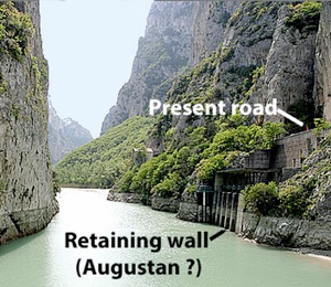
Gola del Furlo: from the website MeteoWeb
As Ronald Syme (referenced below, at p. 282) observed, this route:
-
“... was neither the earliest nor the easiest line of approach to the ... ager Gallicus. Indeed, one part of its course presents extraordinary difficulties for the passage of an army: the Pass of Scheggia itself is both low and easy, but the road must [then] take a course that can only be described as one long defile, for some 25 miles, to the Pass of Furlo” (my change of word order, in order to emphasise Syme’s key point)
Mario Luni and his colleagues (referenced below, at p. 107) gave an interesting assessment of:
-
“... the imposing works performed in order to make the [Gola del Furlo] traversable. The significant remains both of the consular road and its associated structures make [it] an important and renowned archaeological site. Rock cuts and imposing walls [see their Figure 11] were made on the rock spur to the left flank of the Candigliano river, to [make way for] and sustain the road: the amount of removed rock is reckoned at 1500 cubic meters. Later on, two tunnels were opened: a smaller one, the dating of which is uncertain (1st century BC – first half of the 1st century AD), and [a larger one cut by the Emperor Vespasian] in 76 AD.”
According to Simone Sisani (referenced below, 2006, at p. 250) the rock cutting:
-
“... extended for about 180 meters and to a height that at some points exceeded 20 meters along the side of Monte Pietralata to create an artificial terrace that was crossed by the road from its inception in 220 BC. The huge wall overlooking the Candigliano adjacent to the gallery of Vespasian was probably built in the Augustan period during the restoration of a part of the road that was evidently subsiding” (my translation).
I wonder whether the initial project here would have been practical in the circumstances that pertained in 220 BC.
In fact, Gerhard Radke, in a series of publications in 1959-81, suggested that the surviving itineraries for Via Flaminia do not represent its original route across the Apennines. I have not been able to consult these publications directly, but Peter Wiseman (referenced below, at pp. 122-3) provides a good summary of Radke’s basis premises, which included the assumption that each of the Roman consular roads had an eponymous forum at its mid point. Thus, in this case, according to Radke:
-
✴The road built by Caius Flaminius ran through Narnia and Spoletium and on to Forum Flaminii, which was its mid point. It then crossed the pass at Plestia and followed the ancient route to Sentinum, from whence it followed the Misa valley to Sena Gallica.
-
✴In 177 BC, the consul Tiberius Sempronius Gracchus built a new road from Forum Flaminii to Ariminum, via the Gola del Furlo, as evidenced by the constitution of Forum Sempronii, again at the midpoint of the route (provided that one regarded Caesena, beyond Ariminum, as its end point, despite evidence from Livy to the contrary). By the time of the surviving itineraries, this had become the principal route.
Peter Wiseman reasonably concluded (at p. 125) that Radke’s basic premises:
-
“... are too abstract and schematic to support the superstructure of theory which he builds on them.”
He then addressed (at pp. 138-9) Radke’s specific hypothesis for Via Flaminia. In his view:
-
“The Flaminia was surely built for the transport of armies to the north ... [In this context],the main argument against [Radke’s hypothesis] is simply the route itself; from Forum Flaminii over the Plestia pass to Camerinum is a reasonable line, but from there to Sentinum emphatically is not. Hard evidence ... would be needed to prove that any Roman road ran that way.”
However, it seems to me that this specific criticism takes no account of the following facts:
-
✴The route to the coast across the pass at Plestia and through the syncline valley between Camerinum and Sentinum (as proposed by Radke but discounted by Wiseman) was already important by 220 BC: as Pier Luigi Dall’Aglio and Sandro De Maria (referenced below, 2010, at p. 40) observed:
-
“It is therefore not surprising that: the decisive battle between the Romans and the [anti-Roman] coalition ... was fought near Sentinum in 295 BC; nor that, in 283 BC, immediately after the definitive defeat of the Senones, the first colony of [the ager Gallicus], i.e. Sena Gallica, was founded at the mouth of the Misa river” (my translation).
-
✴As noted above, the construction of a new road from the Pass of Scheggia to the Pass of Furlo:
-
•would have been a huge undertaking that might well have been impractical in view of the time constraints; and
-
•would have hardly improved on the existing route between Camerinum and Sentinum, since it would have required an army using it to march through a defile of some 25 miles before reaching the valley of the Metaurus.
In short, while Radke’s basic premises are clearly open to criticism, his suggestion that the original road used the pass at Plestia cannot be so easily discounted: the road via the Gola del Furlo might well have been built after the defeat of the Boii in 191 BC (discussed below), in order to renew the impetus for viritane settlement in the northern part of the ager Gallicus.
Unfortunately, the surviving itineraries are too late to decide the matter and (as we shall see) the surviving archeological evidence from Fanum Fortunae and Forum Sempronii, the two centres that probably owed their existence to the northern stretch of the road, provide only a relatively late terminus ante quem for its construction. There is some circumstantial evidence for Radke’s hypothesisthat is at least worth considering:
-
✴It is generally accepted that Forum Flaminii was constituted as a forum assigned to the Oufentina at the time of the construction of Via Flaminia. This tribe was organised on 318 BC for citizen settlers on land that had been confiscated from Privernum and extended soon after to citizen settlers at nearby Frusino and citizen colonists at nearby Tarracina. According to Lily Ross Taylor (referenced below, at p. 273), the only other extension of this tribe before the Social War was to Forum Flaminii and Plestia: there is evidence for viritane settlement at Plestia in the 3rd century, and it is tempting to hypothesis that this took place in 220 BC. This is discussed in my page ‘Prefectures : Umbria’ (see the link in the boxes at the top and bottom of this page): what is relevant here is the likelihood that, if this was the case, then Via Flaminia crossed the Apennines at the pass at this time, and the citizen settlement at Forum Flaminii and Plestia was part of a single initiative. (Nuceria, further north on the Via Flaminia as it certainly existed by ca. 7 BC, is sometimes assigned to the Oufentina, but this is on the basis of four inscriptions from neighbouring Asisium and is thus highly uncertain.)
-
✴According to Appian, after Hannibal had entered Italy in 218 BC but before his victory at Lake Trasimene in Etruria (described below), the citizens of Rome:
-
“... became greatly alarmed as he drew near, for they had no force at hand fit for battle. Nevertheless, 8,000 of those who remained [in the city] were brought together, over whom Centenius, one of the patricians, although a private citizen, was appointed commander ... [this force was] sent into Umbria to the Plestine marshes, to occupy the narrow passages that offered the shortest way to Rome” (‘War against Hannibal’, 9).
-
It is true that, as discussed below, Appian’s account of Centenius’ activities at this point is possibly inaccurate, not least geographically speaking. Nevertheless, it is also possible that Appian was nevertheless correct in his assumption that, had Hannibal not marched unexpectedly into Etruria but had instead continued along the northern side of the Apennines, ‘the shortest way to Rome’ would have been via the pass at Plestia. In other words, it is possible that, in 218 BC, Via Flaminia crossed the Apennines at the pass at Plestia.
-
✴In 207 BC, when Hasdrubal crossed the Alps in an apparent attempt to meet up with Hannibal in Umbria, Livius Salinator established his camp camp was near Sena Gallica in order to block his advance (as discussed below). If Via Flaminia crossed the Apennines by the Gola del Furlo, this would have made no obvious strategic sense. It seems to me to be more likely that, at this point, it followed the Misa valley and entered Umbria via the pass at Plestia.
However, this evidence is by no means overwhelming.
In fact, the only secure indication we have for the northern route of Via Flaminia before ca. 7 BC dates to 187 BC, after the consuls Marcus Aemilius Lepidus and Caius Flaminius (the son of the builder of Via Flaminia in 220 BC). According to Livy:
-
“Leaving the Ligurians pacified, [Aemilius] led his army into Gallic territory and built a road from Placentia to Ariminum, in order to make a junction with the Via Flaminia”, (‘History of Rome’, 39: 2: 10).
Earlier in this chapter (at line 6), Livy recorded that:
-
“... so that he might not leave his army idle, Flaminius built a road from Bononia to Arretium”
Srabo produced a different account of the road-building of the consuls in 187 BC:
-
“Marcus [Aemilius] Lepidus and Caius Flaminius, being colleagues in the consulship and having vanquished the Ligurians:
-
✴[Flaminius] made the Via Flaminia from Rome across [Etruria and Umbria] as far as the territory of Ariminum; and
-
✴[Aemilius made] the road [from Ariminum] as far as Bononia and thence [north] to Aquileia ...”, (‘Geography’, 5: 1:11).
Most scholars believe that Strabo confused the road that the younger Flaminius built in 187 BC (which Livy had running from Bononia to Arretium) with the road that his father had built from Rome to Ariminum in 220 BC. However, I wonder whether Strabo was at least partly correct: perhaps the stretch of Via Flaminia from Fanum Fortunae to Forum Flaminii via the Gola del Furlo was built at this point, under the auspices of the younger Flaminius.
Fanum Fortunae
Fanum Fortunae is located on the Adriatic coast, near the point at which the Via Flaminia turned northward to follow the coast towards its end point at Ariminum.
As Pier Luigi dall’Aglio and his colleagues (referenced below, 2017, at p. 118) pointed out, Fanum Fortunae (modern Fano):
-
“... is located on the [Adriatic, but] unlike the other [towns on this stretch of coast, Ariminum, Pisaurum and Sena Gallica], the mouth of the main river was not a factor in the location of the city centre. In fact, Fanum Fortunae is not located near the mouth of the Metauro, which runs about 3 km further south of the city). The ending of the main Via Flaminia towards the sea is instead what affected the construction of the Roman city.”
In other words, Roman Fanum Fortunae was built after the construction of this part of the Via Flaminia. Its name means “Shrine of Fortuna’ and it is extremely likely that there was a shrine dedicated to Fortuna here that also pre-dated the building of the city.
An inscription (AE 1983, 0379) that was reused in an Augustan building that has been excavated under the church of Sant’ Agostino at Fano, records a quattuorvir, Publius Scantius. The find spot suggests that he had held office at Fanum Fortuna, so we might reasonably assume that this centre had been important enough to have been municipalised and given a quatturovirale administration soon after the Social War. The EAGLE database (see the AE link) proposes an Augustan date for the inscription, but this is too late, since Fanum Fortunae was almost certainly a colony administered by duoviri at this time:
-
In his account of the urban centres on the coast of the Augustan Sixth Region, Pliny the Elder included:
-
“... the colonies of Fanum Fortunæ and Pisaurum ... ” (‘Natural History’, 3:19).
-
An inscription (CIL XI 6232) from the 1st century AD refers to the Colonia Iulia Fanestris.
-
Laurence Keppie (referenced below, at p. 77) includes Fanum Fortunae among the colonies founded by Octavian/ Augustus after the Battle of Actium (30 BC).
I suspect that the Augustan date belongs instead to the building in which the earlier inscription had been reused.
The earliest documentary reference to Fanum Fortuna in the surviving sources is from Julius Caesar (who wrote of himself in the third person and in the present tense): he recorded that, having crossed the Rubicon in 49 BC, he:
-
“... stops at Ariminum with two cohorts and arranges to hold a levy there; he occupies Pisaurum, Fanum and Ancona, each with one cohort.” (‘Civil Wars’, 1:11).
Strabo, who was writing some four decades later, recorded that:
-
“Starting at Ravenna, the [Umbrians] inhabit the neighbouring country together with the cities of Sarsina, Ariminum [and] Sena [Gallica] ... To their country likewise belongs the river Esino, Mount Cingulum, Sentinum, the river Metaurus, and the Fanum Fortunæ ... There are also other cities [on the Via Flaminia that are] well populated, rather on account of the route along which they lie, than for their political importance: ... [these include] Forum Sempronium”, (‘The Geography’, 5: 2: 10).
Isobel Pinder (referenced below, at p. 242) suggested that Strabo’s Fanum Fortunae was a temple rather than to an urban settlement. It is certainly true that Strabo placed Fanum Fortunae among a hybrid list that included two rivers and a mountain, rather than among either his list of coastal cities or of cities and smaller centres on Via Flaminia. However, this hybrid list also included Sentinum, presumably meaning the quattuorvirale municipium (see below) rather than the river.
Via Flaminia, Fanum Fortunae and Nearby Viritane Settlement
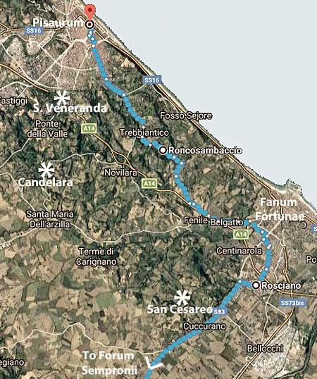
San Cesareo
The inscription (CIL XI 6331) on a cippus from San Cesareo, some 8km south of Fanum Fortunae, records that, in ca. 80 BC, the future consul Marcus Terentius Varro Lucullus restored the boundary stones that had been set up originally by the triumvirs Publius Licinius, Appius Claudius and Caius Gracchus. The mention of the last of these suggests that the stones would have originally marked the boundaries of land assigned to new settlers in the Gracchan distributions of ca. 130 BC. The find spot of the cippus suggests that the land in question was on or near Via Flaminia. Saskia Roselaar (referenced below, 2010, at p.45) observed that:
-
“The land distributed in the Gracchan period [as evidenced by CIL XI 6331] must have been ager publicus since its conquest in the 3rd century BC.”
The fact that Terentius restored its boundaries in ca. 80 BC might suggest that the distributed land had been misappropriated in the intervening period.
Line of Via Flaminia
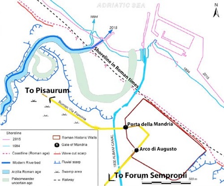
Adapted from P. L. Dall’Aglio et al., (referenced below, 2017, Figure 5, at p. 118)
Yellow line = authors’ proposed route of Via Flaminia
Simone Sisani (referenced below, 2006, at p. 256), who followed the line of Via Flaminia from San Cesareo towards the coast, suggested that it did not continue ahead to modern Fano but:
-
“... rather turned north towards Pesaro just after modern Rosciano and [continued through] Roncosambaccio and Trebbiantico [all marked on the map above, with the blue dots marking the modern road connections]” (my translation).
Pier Luigi dall’Aglio and his colleagues (referenced below, 2017, at pp. 118-9 and Figure 5) demonstrated that this route would have avoided a low-lying swampy region that had been created by what had once been a huge meander in the Arzilla river. They showed Via Flaminia entering Fanum Fortunae via the Arco di Augusto and leaving by the Porta della Mandria. However, as discussed below, it seems that the road skirted the city and tha a branch road of Via Flaminia entered the city through the Arco di Augusto.
Fanum Fortunae
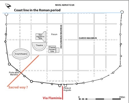
Roman remains at Fano
Adapted from Isobel Pinder, referenced below, at p. 34, Figure 10
As Isobel Pinder (referenced below, at pp. 32-3) observed:
-
“.... there is surprisingly little evidence for ... [a] nucleated settlement on the [site of modern Fano] until the Augustan period. ... The walls, street grid, aqueduct, drains and sewers and forum area are all considered to belong to the period immediately following the foundation of the [Augustan] colony.”
The Arco di Augusto, which was the main entrance to the colony, carries an inscription (CIL XI 6218) that records the construction by Augustus himself of the city walls (and presumably its gates) in 9 BC.
The only other known city gate, Porta della Mandria, was rediscovered in 1925 and subsequently reconstructed. Isobel Pinder (referenced below, at p. 38) observed that:
-
“The nature and purpose of Porta della Mandria have been much debated. It is often assumed that the Via Flaminia exited the city here and headed towards Pisaurum [as discussed above] However, there is no obvious connection in the street layout between an entrance to the city through [the Arco] di Augusto and an exit at Porta della Mandria”.
In other words:
-
✴through traffic on Via Flaminia probably skirted the city on its southwestern side; and
-
✴a branch road that constituted its decumanus maximus gof the city ave access to it via the Arco di Augusto.
Isobel Pinder (as above) expressed the opinion that Porta della Mandria:
-
“... is better understood in relation to:
-
✴the city’s theatre, amphitheatre and probable temple/sanctuary complex [at Sant’ Agostino, discussed below]; and
-
✴the ‘diagonal’ road, [marked ‘sacred way ?’ in the plan above, which is] clearly distinguishable in the street plan and narrower than other roads in the urban grid.
-
The unexpected orientation of this road suggests that it may [have] pre-dated the Augustan development of the city, but was [nevertheless] important enough not only to be preserved within the street grid but also to merit its own gateway.”
If this is correct, then this road is essentially all that remains of the pre-colonial municipium. Pinder suggested that:
-
“It may have been a sacred way which maintained the memory of an earlier route to a sanctuary outside the city, perhaps the original sanctuary of Fortuna itself.”
I discuss this possibility below.
Roncosambaccio
Francesca Giovannini (referenced below, at schedule 30-30B) described some Roman remains that survive further along Via Flaminia, at Roncosambaccio, about 5 km northwest of Fanum Fortunae (marked on the map above). She observed that they:
-
“... might relate to a villa or a sanctuary:
-
✴In favour of the first hypothesis are:
-
•the types of materials found, including numerous fragments of earthenware vessels and amphorae; and
-
•the presence of other similar structures in the territory of Novilara [some 3 km to the southwest].
-
✴In favour of the second hypothesis are:
-
•the comparison with important Republican sanctuary of Monte Rinaldo [in Picenum];
-
•the dominant position of the site; and
-
•the discovery at nearby Candelara of an inscription [CIL XI 6307 - see below], which testifies to the existence of other cult sites” (my translation).
Simone Sisani (referenced below, 2006, at p. 266), who had no doubt that these remains indicated a sanctuary from the middle of the 2nd century BC, observed that:
-
“These remains constitute one of the earliest testimonies to a Roman presence in the area of Fano” (my translation).
The possibility that these remains related to the original Fanum Fortunae is discussed below.
Shrine of Fortuna ?
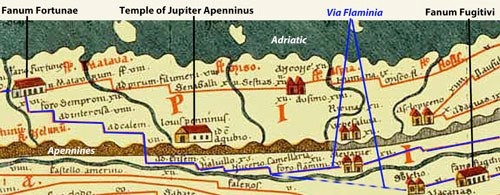
Tabula Peutingeriana (from the website by the Biblioteca Augustana der Fachhochschule, Augsburg)
Via Flaminia in blue: the dotted line projects the tract from Spoletium to Forum Flaminii
As Isobel Pinder (referenced below, at p. 33) observed that:
-
“The name Fanum Fortunae suggests that a cult or sanctuary to Fortuna was located in the area, but its exact location has proved remarkably elusive.”
John Scheid (referenced below, at p. 83) expressed the opinion that the colony that Octavian founded here after the Battle of Actium (30 BC) was:
-
“... on a site that was manifestly a sanctuary of Fortuna. but not a town. [Despite efforts to recognise a nucleated settlement here associated with the lex Flaminia Agraria and to have it] become a municipium and then an Augustan colony, ... there in no certainty on this subject. The earliest certain information comes from ... Caesar, who occupied [a place called] Fanum ... Anyway, a municipium or a colony bears the name of a cult site and a goddess is sufficiently rare that that we might reasonably consider whether [Fanum Fortuna] was a sanctuary transformed into a city” (my translation and my bold italics).
However, Daniele Miano (referenced below, at p. 70) argued that the existence of a cult site cannot be inferred from the name alone:
-
“In spite of the evocative name [of Fanum Fortunae], we do not have any literary sources explicitly saying that there was a temple of Fortuna [there] and, even more strangely, there is not a single dedication from Fanum attesting the worship of Fortuna. One may think that this is just a matter of chance, and that, in a town called ‘Temple of Fortune’, there must have been a temple of Fortune. This might very well have been the case, at least from the time of the colony, but, given the uncertainty of the evidence, I prefer not to venture in speculation ...”
On balance, I think that there is circumstantial evidence that supports the hypothesis that the nucleated centre at Fanum Fortunae owed its name (and perhaps its existence) to the existence of a cult site. A search of the Digital Atlas of the Roman Empire reveals only two ancient places in peninsular Italy that were named for fana: Fanum Fortunae; and Fanum Fugitivi (in Umbria, between modern Terni and Spoleto). As indicated by the detail above of the so-called Tabula Peutingeriana (ca. 250 AD), both were on Via Flaminia: in fact, the isolated Fanum Fugitivi was at the highest point on its route. Each of these places is marked by a building that was probably a temple, as evidenced by the fact that a similar building marked ‘Jupiter Apenninus near Gubbio’: while none of these buildings can now be located, the Temple of Jupiter Apenninus was securely documented throughout the imperial period. Thus, it is in my view at least possible that each of Fanum Fortunae and Fanum Fugitivi was, or was named for, a local and important shrine.
Since we cannot securely locate the putative shrine of Fortuna, it is obviously difficult to suggest a date for its construction. However, John Scheid (referenced below, at p. 83) made two observations that might provide some indication:
-
✴His first observation relates to the probably Roman provenance of the goddess Fortuna:
-
“Unless Fortuna was the Latinised name of a local goddess, she was a goddess who was exclusively Roman or Latin. If that is the case, [the shrine] would be a Roman foundation linked to the construction of Via Flaminia and/or the first colonisation” (my translation).
-
That would give a terminus post quem of 220 BC (whether Via Flaminia originally approached the site from Sena Gallica or from Forum Sempronii). However, as noted above, the location of the colony was apparently determined by the existence of the road from Forum Sempronii, which could give us a terminus post quem of ca. 19o BC as opposed to 220 BC (as discussed below).
-
✴His second observation relates to the surviving accounts of the Battle of the Metaurus (207 BC), in which the Romans defeated Hasdrubal, the brother of Hannibal (as I discuss below), a victory that probably marked the ‘beginning of the end’ of the Second Punic War:
-
“In spite of the proximity [Fanum Fortunae] to the mouth of the Metaurus, neither the sanctuary nor the city is mentioned [in the surviving sources for this battle]” (my translation).
-
Although it would be an argument from silence, it might nevertheless allow a terminus post quem of the earlier of:
-
•207 BC; or
-
•the date of construction of the Roman road from Forum Sempronii, possibly ca. 190 BC).
In other words, we might well be dealing with a sanctuary that was founded in the late 3rd or early 2nd century BC.
It is sometimes suggested that it was first built in order to commemorate the Roman victory here in 207 BC. The evidence (such as it is) for a possible link between the sanctuary and the battle comes from Ovid’s ‘Fasti, which recorded:
-
✴23rd June as the anniversary of the day on which:
-
“... Massinissa conquered Syphax and Hasdrubal fell by his own sword”, (, 23rd June)
-
Massinissa, King of Numidia and Scipio Africanus defeated a Carthaginian army led by the Berber King Syphax in North Africa in 203 BC. It is therefore possible that Ovid’s Hasdrubal was Hasdrubal the son of Giso, who was on the losing side in this battle and who committed suicide in the following year. However, some scholars (see, for example, Joy Littlewood, referenced below, at p. 222) suggest that Ovid referred to two separate events here, and that his Hasdrubal had died on the Metaurus in 207 BC (albeit that Livy had him killed in battle and there is no other surviving evidence for suicide).
-
✴24th June as the date of the Roman festival of Fors Fortuna:
-
“How swiftly the festival of Fors Fortuna’s arrived! June will be over now in seven days. Quirites, come celebrate the goddess Fors, with joy ... The people worship her, because they say that Servius [Tullus, King of Rome] built the shrines of the fatal goddess [on the Tiber]”, (‘Fasti’, 24th June).
If Ovid’s Hasdrubal was the defeated commander at the Battle of the Metaurus, then it is possible that this Roman victory was celebrated in Rome on the feast of Fors Fortuna: in that case, the original sanctuary near or at Fano might have been built in commemoration of this victory. I have to say that, while the proposition itself is attractive, and would account for the local importance of the site, the evidence itself is some way short of compelling.
Although, as Daniele Miano (above) pointed out, there are no known dedications to Fortuna that be securely linked to Fano, Antonella Trevisiol (referenced below, at p. 159, entry 45) suggested that a relevant inscription (AE 1962, 0307):
-
“... might have been found at Fano: it was donated to the Museo di Fiesole by the marchese Carlo Strozzi [in 1884], having passed through the hands of a number of collectors. If [it could be securely linked to Fano], this would be the oldest record of the cult of Fortuna found here” (my translation).
The inscription is usually dated to the 3rd century BC, although Trevisiol suggested the early 2nd century BC. Daniele Miano (referenced below, at p. 71) has translated the inscription as follows:
-
“If you will obey (me), I will not ruin (you); if you will not obey (me), (remember that), because of Fortuna, Servius is (or was) ruined.”
It is on a smooth pebble (illustrated by Isobel Pinder, referenced below, at p. 245, Figure 129) that would have been used as a lot or token (known as a ‘sors’) that might be drawn during a ritual of divination. Thus, this was one of a number of possible answers to a question put to the goddess. This answer is generally taken to refer to Servius Tullus and the goddess Fortuna, although, Daniele Miano cautioned (at p. 72) that this is by no means beyond doubt. Unfortunately we have very little information relating to the find spot and none relating to the archeological context. Margherita Guarducci, who originally published the inscription, reasserted (in the paper published below, at p. 131) that the museum records of the donation in 1884 gave the provenance of the object as the Marche. She pointed out (at p. 136) that no alternative credible provenance has been established and observed (at pp. 136-7) :
-
“Having restored (until proven wrong) the pebble to the Marche, we might ask which precise location should be preferred. Where, in the Marche, is there an ancient sanctuary where Fortuna used to give her responses? The mind soon turns to the famous Fanum Fortunae, from which the modern city of Fano takes its name” (my translation).”
However, Daniele Miano pointed out (at p. 73) that this object:
-
“... could have come from any sanctuary (not necessarily one of Fortuna), or it could have been part of the collection of an itinerant diviner.”
In other words, while an inscription that mentions Fortuna and that seems to have been found in the Marches might cause the mind to turn to Fanum Fortunae, but this would be no more than an interesting speculation.
However, a dedication to Fortuna can be securely associated with Candelara, some 14 km inland from Fano: this inscription CIL XI 6307, which is on a cippus, reads:
[F]ortunae/ [Respic]ienṭị/ sacrum
Thus, it was dedicated to Fortuna Respiciens, which was also the dedication of two ancient shrines in Rome (one on each of the Equiline and Palatine hills). The EAGLE database (see the CIL link) dates this inscription to second half of the 1st century BC, while Simone Sisani (referenced below, 2007, at pp. 391-2) had it not later than the end of the 2nd century BC. However, as shown on the map above, Candelara is only about 4 km from Santa Veneranda, the site of the lucus Pisaurensis, discussed above. Simone Sisani (referenced below, 2007, at pp. 391-2) observed that the cippus from Candelara:
-
“... is closely analogous - in respect of form, material and dimensions - to the cippi from Santa Veneranda” (my translation).
Thus, the inscription could have come from a sacred grove in this location, although, given the wide spectrum of deities venerated at the lucus Pisaurensis, we cannot assume that this putative grove at Candelara was dedicated exclusively to Fortuna.
As noted above, John Scheid believed that Octavian/Augustus founded the colony at Fanum Fortunae precisely on the site of the earlier sanctuary. There is evidence that Octavian/Augustus attributed his victory at Actium to (inter alia) the goddess Fortuna, and this might indeed have influenced his decision when locating the colony. If so, then one might expect that he would have re-established a shrine of Fortuna within its walls. Some scholars have suggested that this putative Augustan shrine might be identified with the structure excavated under the church of Sant’ Agostino (marked in the street plan above). Isobel Pinder (referenced below, at pp 247-8) surveyed the evidence and observed that:
-
“It is probably best to conclude that the [function of the] Sant’ Agostino structure cannot yet be securely identified. [However,] given its size and prestigious nature. it was clearly a monumental public building and may have the best claim of urban sites so far discovered to being the long-sought sanctuary [of Fortuna] rather than the equally sought-after [documented but not securely located] basilica of Vitruvius.”
If so, then the putative earlier sanctuary of Fortuna could once have stood on this site (as Scheid suggested).
However, one wonders whether he would have obliterated an established and important shrine of Fortuna when founding his colony. Isobel Pinder (referenced below, at p. 38) made the alternative suggestion: the original sanctuary survived and was linked to the colony by the otherwise anomalous ‘diagonal‘ road through the Porta della Mandria (described above), that would thus have functioned as a ‘sacred way’. She discussed (at pp. 243-5) a number of alternative possible locations for this extra-urban shrine, concluding ( at p. 33) that :
-
“... the most promising ... candidate is at Roncosambaccio [described above], in view of its location, ease of access [from Porta della Mandria] and [possible] association with Fortuna. Architectural fragments including doric capitals and columns have been discovered here and may belong to a sanctuary dating back to the mid 2nd century BC.”
As noted above, it is not absolutely clear that these remains came from a religious rather that a secular building. More importantly, Pinder’s suggested association of these remains with the goddess Fortuna relies on the existence of the inscription at Candelara (above), some 8 km from Roncosambaccio. In fact, Roncosambaccio is slightly closer to Santa Veneranda and the remains there could have been associated with any or none of the deities venerated in these locations. In my view, Pinder’s identification of Roncosambaccio as the site of the original shrine of Fortuna must rely solely on her identification of the putative sacred way that linked this site to the Porta della Mandria.
Having said that, I find the idea of the putative sacred way leading to the original sanctuary (whether or not precisely at Roncosambaccio) quite compelling: it might even have linked Octavian’s new colony for the veterans of Actium to the shrine that commemorated the equally iconic Roman victory over Hasdrubal almost two centuries earlier: rather than being a victory against fellow Romans, Actium had been another victory willed by Fortuna over the barbarian enemies of Rome. Unfortunately, as will be clear from the above material, there is very little hard evidence that might support this pleasant speculation.
Fanum Fortunae: Conclusions
As noted above, it seems to me that, like Fanum Fugitivi, Fanum Fortunae probably started out life as a shrine of some kind on Via Flaminia. Since the original road apparently skirted the later colony, this was unlikely to have been the original site of this shrine, although we cannot rule this out. Isobel Pinder’s suggestion that the original shrine was located further along Via Flaminia, perhaps at Roncosambaccio, is reasonable but not beyond doubt. In any case, the discovery of a Republican shrine dedicated on this stretch of Flaminia that could be securely attributed to a Fanum Fortunae would not necessarily, on its own, signify viritane settlement: after all, as far as I am aware, there is no reason to think that the Fanum Fugitivi on Via Flaminia was ever anything other than an isolated wayside shrine.
Nevertheless, Simone Sisani might correct that the reasonably substantial remains at Roncosambaccio speak to viritane settlement in the 2nd century BC. The inscription (CIL XI 6331) from San Cesareo attests to further viritane settlement on what was presumably ager publicus here in ca. 130 BC. However, there is nothing in the surviving archeological record to suggest earlier viritane settlement in the area around Fano.
The earliest surviving evidence for an urban centre at Fano is in the form of the inscription (AE 1983, 0379) on a block that was reused in an Augustan building: the inscription records a quattuorvir, which implies municipalisation after the Social War. It is thus possible that this municipium was located on the site of the later colony, although it is important to remember that the original location of the inscription is unknown. The only other indication of settlement of this site before colonisation in ca. 30 BC seems to be the narrow road (Isobel Pinder’s sacred way) that passed through the later Porta della Mandria. Thus, it is possible, as John Scheid suggested, that the Augustan colony was the first urban centre established at modern Fano.
Forum Sempronii
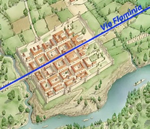
Forum Sempronii, above the Metauro
Reconstruction from the website of Proloco Fano
The remains of Forum Sempronii have been excavated at San Martino di Piano, some 7 km northeast of modern Fossombrone (see the map below). According to Oscar Mei (referenced below, at p. 378):
-
“The Roman city is on a vast terrace of the Metauro River, about 20 metres above the level of the modern river bed. The city’s perimeter on both southwestern and southeastern sides coincides with the edge of fluvial scarps [formed by an ancient meander in the river that was subsequently abandoned] ... Today the Metauro River runs in an approximately E-W direction, thus deviating from the fluvial scarp which [still marks part of the boundary of the site]”.
According to Patrizia Ferretti (referenced below):
-
“Natural boundaries were formed by the hills to the north, [a ditch known as the] Fosso della Conserva to the west, and the bed of the Metaurus river to the south. There was no natural boundary to the east, where it was certainly enclosed by a wall (of which remains are preserved) ...” (my translation).
An inscription (CIL XI 6136), which dates to the 1st or 2nd century AD, records that a trade guild had a cemetery near a gate in this wall called the Porta Gallica.
Patrizia Ferretti (referenced below) also described what is known about the history of the settlement, which :
-
“... was founded on the [Via Flaminia] by an unknown magistrate of the gens Sempronia (according to the tradition Gaius Sempronius Gracchus) in the 2nd century BC” (my translation).
Many scholars are less circumspect in relation to the identity of the member of the gens Sempronia who was responsible for constituting the forum here: for example, according to Oscar Mei (referenced below, at p. 378):
-
“Forum Sempronii was [probably founded ... by Caius Sempronius Gracchus, whose presence in that area is documented by an inscription [CIL XI 6331, on a boundary cippus from San Cesareo, some 20 km north of Forum Sempronii, as discussed above. This inscription] mentions the activity of the triumviral committee appointed to enforce the lex Sempronia of 133 BC, aimed at reorganising the ager publicus by parcelling out and allotting the agricultural land [to new settlers from Rome].”
An inscription (CIL XI 6132) from the site, which dates to some time in the period 50 BC - 50 AD records a duovir quinquennalis, which suggests that Forum Sempronii was municipalised some decades after the Social War. This duovir, Caius Marius, belonged to the Pollia, which was the tribe of Forum Sempronii. Ferretti also noted that:
-
“The archaeological record indicates that the municipium had a period of particular prosperity in the first two centuries of the Imperial period ...” (my translation).
This is supported by the dating of the inscriptions from Forum Sempronii published by Antonella Trevisiol (referenced below, at pp. 105-27. Ferretti continued:
-
“It had an area of about 24 hectares and a chessboard street plan that was aligned with the Via Flaminia, which constituted the main east-west axis (decumanus maximus) of the city” (my translation).
This accords with Strabo’s statement that:
-
“There are also other cities [on Via Flaminia that are] well populated on account of the route along which they lie, rather than for their political importance. Such [is] ... Forum Sempronii”, (‘The Geography’, 5: 2: 10).
Forum Sempronii featured on all of the surviving later itineraries along Via Flaminia, to which it obviously owed its existence.
Viritane Settlement in the Area
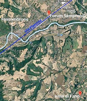
Forum Sempronii and its territory
Simone Sisani (referenced below, 2007, at p. 198) recorded that finds from a votive deposit at Isola di Fano (some 7 km south of Forum Sempronii, marked on the map above) included coins from about the date of the lex Flaminia agraria (232 BC). Thus, we might reasonably assume that this area received citizen setters at this time.
Forum Sempronii: Conclusions
All we can really say about the initial constitution of Forum Sempronii derives from Strabo, who placed it on Via Flaminia in ca. 7 BC. We know for certain from later itineraries and from archeological evidence that this centre was located at San Martino di Piano. The presence of a duoviral constitution here suggests municipalisation in the middle of the 1st century BC, but nothing in the surviving archeological record illuminates its history before that point. We can reasonably assume that:
-
✴a prominent member of the gens Sempronia was responsible for the constitution of Forum Sempronii; and that
-
✴the triumvir Caius Graccus mentioned in the inscription (CIL XI 6331) from San Cesareo was Caius Sempronius Gracchus, the tribune of 123 and 122 BC, and attests to viritane settlement there under the lex Sempronia agraria that his brother Tiberius had promoted in 133 BC.
However, San Cesareo is some 20 km from Forum Sempronii, and there is no archeological or other evidence that links Forum Sempronii with the Sempronii Gracchi in the late 2nd century BC: in principal, any prominent member of the wider gens Sempronia could have constituted Forum Sempronii from the time of its construction (in 220 BC or ca, 190 BC, according to taste).
It is true that the literary sources record that Caius Sempronius Gracchus was much concerned with road building:
-
✴According to Appian:
-
“[Caius] Gracchus also made long roads throughout Italy and thus put a multitude of contractors and artisans under obligations to him and made them ready to do whatever he wished”, (‘Civil Wars’, 1: 23).
-
✴According to Plutarch:
-
“[Caius Gracchus] introduced bills for sending out colonies, for constructing roads, and for establishing public granaries, making himself director and manager of all these undertakings ... [and carrying] out each one of them with an astonishing speed ... But he busied himself most earnestly with the construction of roads, laying stress upon utility, as well as upon that which conduced to grace and beauty. For his roads were carried straight through the country without deviation, and had pavements of quarried stone, and substructures of tight-rammed masses of sand. Depressions were filled up, all intersecting torrents or ravines were bridged over, and both sides of the roads were of equal and corresponding height, so that the work had everywhere an even and beautiful appearance. In addition to all this, he measured off every road by miles ... and planted stone pillars in the ground to mark the distances. Other stones, too, he placed at smaller intervals from one another on both sides of the road, in order that equestrians might be able to mount their horses from them and have no need of assistance”, (‘Life of Caius Gracchus’, 6-7).
Penelope Davies (referenced below, at p. 179) observed that, despite his lack of a construction mandate in his periods as tribune in 123 and 122 BC, Plutarch, in particular, credited him with extensive road-building activity. Nevertheless, she pointed out that:
-
“... no known Via Sempronia has been identified archeologically, and no surviving milestone names him; with the exception of the Via Fulvia in the Cisalpina, ... all known roads built between 133 and 109 BC were the work of his opponents or, at least, of men associated with the senatorial majority. It is possible that he reworked existing thoroughfares, replacing milestones with the names of the original constructors, or that ... [a planned project] never progressed beyond the planning stage; the Senate may even have appropriated [this putative] scheme as its own.”
In other words, despite Plutarch’s testimony, there is no particular reason to assume that the activities of Caius Gracchus at San Cesareo as triumvir were the precursor of the restoration of Via Flaminia and the constitution of Forum Sempronii during his period as Tribune.
Flaminius, Forum Sempronii and Fanum Fortunae: Conclusions
We know from Livy that Caius Flaminius built a consular road from Rome to Ariminum in 220 BC and that it certainly reached Ariminum by 187 BC. However, no surviving literary source records the Apennine pass by which it originally reached this destination: all we know is that it used the Gola del Furlo from at least ca. 7 BC. Unfortunately, the scant archeological evidence from the territory along the route from Gola del Furlo via Forum Sempronii to Fanum Fortunae offers no help here: all we can say is that there seems to have been a Gracchan distribution at San Cesareo in ca. 130 BC.
As noted above, Simone Sisani (referenced below, 2007, at p. 217) argued that, in spite of the similar lack of archeological evidence for viritane settlement of any kind near Forum Sempronii and Fanum Fortunae before the middle of the 2nd century BC:
-
“The settlement initiative realised by Flaminius ... in 232 BC must have directly affected the territories of ... [these two centres]” (my translation).
He made two specific points in favour of his hypothesis:
-
✴“[Their] location ... on the later route of the Via Flaminia makes obvious the connection between the [putative viritane] settlement here and [Caius] Flaminius” (my translation).
-
✴“[Their] inclusion ... in a single tribe, the Pollia, demonstrates that we are dealing with a single initiative, identifiable only with the [lex Flaminia agraria of 232 BC]” (my translation).
However, as I discussed above, neither of these two points is beyond argument:
-
✴We cannot be sure that Via Flaminia originally passed through the later site of Forum Sempronii. Nor can we hypothesis viritane settlement here at a date that is not supported by the archeological record, notwithstanding Flaminius’ agrarian law of 232 BC and his construction of the Via Flaminia in 220 BC.
-
✴The Pollia was the tribe that was almost always assigned to new citizen communities in the ager Gallicus, Cisalpine Gaul and Liguria from 283 BC, when the citizen colonists sent to Sena Gallica were so-assigned. Thus, no particular significance can be attached to the facts that:
-
•Forum Sempronii was assigned to the Pollia at the unknown date of its constitution; and
-
•Fanum Fortunae was so-assigned on municipalisation/ colonisation in 90/ 30 BC.
In the absence of new evidence to the contrary, we must conclude that this part of the ager Gallicus remained in largely unsettled for decades after Flaminius’ initiatives of 232 and 220 BC. It is possible that the sudden deterioration in the security situation in 218 BC (discussed below) would have deterred settlement in the border zone despite these initiatives. However, that problem ended in 190 BC, and it is possible that Via Flaminia was diverted via the Gola del Furlo in the following decade. The apparent scarcity of settlement here thereafter remains something of a mystery.
Second Punic War (218 - 201 BC)
Boian Revolt (218 BC)
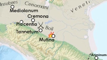
As I discussed above, in 218 BC, as the Romans became aware of Hannibal’s advance in Spain and the consequent threat of an invasion via Cisalpine Gaul, they accelerated their plans to found the colonies of Placentia and Cremona in the Po valley: together with Ariminum, these colonies would constitute the first line of defence, should Hannibal succeed in crossing the Alps. However, this provoked the Boii, who might reasonably hope to benefit from the potentially the imminent invasion. They therefore abandoned the hostages that they had given to Rome in 224 BC and persuaded the Insubres to join them in revolt. They attacked the new colonies, forcing the colonists to flee to the Roman garrison at Mutina, and further ambushed the Roman 4th legion, whom they besieged in the village of Tannetum. An army that was preparing to leave Rome for Spain was quickly despatched under the praetor Caius Atilius. The Boii abandoned Tannetum on Atilius’ approach, and he was probably also able to relieve the siege of Mutina (although the surviving sources are not specific here). Thus, the revolt was ended for the moment, albeit that the precarious state of security on the northern border had been laid bare.
Hannibal’s Invasion of Italy (218 -7 BC)
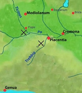
Carthaginian victories on the Ticinus and on the Trebbia (218 BC)
Adapted from a map in the website ‘Indian Defence’
Hannibal duly crossed the Alps and marched into Italy in the winter of 218 BC and secured the allegiance of the Insubres:
-
✴In November, he confronted the army of the consul Publius Cornelius Scipio (the father of Scipio Africanus) on the Ticinus river. He had the best of the fighting, but the Romans were able to retreat to Placentia, taking the wounded Scipio with them.
-
✴The other consul, Tiberius Sempronius Longus, who had also been called back to Italy, landed at Ariminum and joined forces with Scipio. The people of Cisapline Gaul seem to have been subject to Carthaginian looting, and Sempronius sought to win their support by attacking looting parties. Hannibal was able to draw Sempronius’ army into an ambush between the Trebbia and the Po. Again, he had the best of the fighting, but Sempronius was able to fall back on Placentia.
Thus the Romans’ hard-won control of the Po valley had proved to be illusory, and the threat of a Carthaginian invasion of Rome was very real indeed.

Red line: probable route of Hannibal’s march to Lake Trasimene (217 BC)
Blue line: Via Flaminia
Adapted from a map in the website ‘Indian Defence’
Battle of Trasimene
This was the position when the consuls of 217 BC, Caius Flaminius (the builder of Via Flaminia) and Cnaeus Servilius Geminus, took office. The task now was to defend Hannibal’s likely routes towards Rome. Like the Gallic army of 225 BC, he had essentially two possible routes across the Apennines:
-
✴through the pass that led to Etruria (as in 225 BC); or
-
✴along the Adriatic coast.
According to Livy, the Senate ordered Flaminius to take charge of the army at Placentia after his ritual inauguration. However, he defied tradition by refusing to observe these rites before leaving Rome. Instead, according to Livy, he:
-
“... [stole] away furtively without his insignia of office, and without his lictors, just as though he were some menial employed in the camp and had quitted his native soil to go into exile. He [apparently thought it] more consonant with the greatness of his office to enter upon it at Ariminum rather than in Rome, and to put on his official dress in some wayside inn rather than at his own hearth and in the presence of his own household gods. ... [This extraordinary inauguration complete,] Flaminius [then] took over the two legions [he had sent for from Placentia] ... and commenced his march to Etruria through the passes of the Apennines”, (‘History of Rome’, 21: 63: 9-14).
Rachel Feig Vishnia (reference below, 2012, at p. 43) reasonably asserted that:
-
“The allegation that Flaminius left [Rome] for his province before officially assuming office and [that he] neglected his religious duties is exaggerated. ... After two embarrassing defeats in the Po valley and in view of Hannibal's imminent invasion, time was running short. Accordingly, ... [the new consuls] probably began their arrangements immediately after their election. It is not implausible that Flaminius, who knew the prospective battle zone well, left [immediately for the front, while Servilius stayed in Rome] to perform all the religious ceremonies. [Flaminius] went to Ariminum first ... where he checked on the preparedness of the colony and received the legions [sent to him from Placentia]. After assuming office, he then left for Arretium, where he arrived in early mid April [217 BC].”
Rachel Feig Vishnia is surely correct in her assessment of Flaminius’ actions on taking office. However, it is difficult to resist the feeling that his trip along his new road, now consul for the second time and the prospective saviour of Rome, also had a sadly-misplaced air of self-congratulation about it.
We know from Polybius (‘Histories’, 3: 86) that the properly inaugurated Servilius then took charge of another army at Ariminum: thus Arretium and Ariminum now constituted the first line of defence against an invasion of Rome. Fortunately for the settlers in the ager Gallicus, Hannibal, who chose to march into Etruria. Roman intelligence failed spectacularly, and he had passed Arretium before Flaminius even realised what was happening. Flaminius belatedly marched after him, but Hannibal ambushed him on the shores of Lake Trasimene. Within a matter of a few hours, Flaminius and most of his army were dead.
Defeat of Caius Centenius
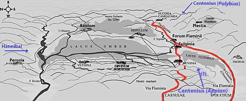
Hypothetical location of the Lacus Umber and Lacus Plestinus [credit needed]
Via Flaminia (in red) assumes both Umbrian branches existed and that the
road crossed the Apennines via the Gola del Furlo (to the north of Nuceria)
Another disaster followed in the wake of the catastrophe at Trasimene: according to Polybius:
-
“About the same time as this battle, the consul Cnaeus Servilius, who had been stationed on duty at Ariminium, ... having heard that Hannibal had entered Etruria and was encamped near Flaminius, designed to join the latter with his whole army. But, finding himself hampered by the difficulty of transporting so heavy a force, he sent Caius Centenius forward in haste with 4,000 horse [as an advance party]. But Hannibal, getting early intelligence [of this development]..., sent Maharbal with his lightly-armed troops and a detachment of cavalry. Maharbal ... killed nearly half [of Centenius’] men at the first encounter; and, having pursued the remainder to a certain hill, took them all prisoner on the following day. The news of the battle of [Trasimene] was only three days' old at Rome, and the sorrow caused by it was, so to speak, at its hottest, when this further disaster was announced” (‘Histories’, 3: 86).
Livy gave a similar account of this second disaster:
-
“[Soon after the defeat at Trasimene] ... another unexpected defeat was reported [at Rome]: 4,000 horse, which had been sent under the command of [Caius] Centenius, propraetor by the consul Cnaeus Servilius [to reinforce Flaminius], were cut off by Hannibal in Umbria, to which place, on hearing of the battle at [Trasimene], they had turned their course” (‘History of Rome’, 22:8).
Unlike Polybius, Livy did not record the place from which Servilius had sent Centenius. However, he added the important detail that Centenius’ defeat had occurred in Umbria.
Appian was more specific (although not necessarily more accurate) about these events:
-
✴Before Trasimene:
-
“The greater part [of the Roman army] was dispatched against Hannibal under [the consuls] Cnaeus Servilius and Caius Flaminius ... Servilius hastened to the Po ... [and] Flaminius, with 30,000 foot and 3,000 horse, guarded Italy within the Apennines .... Thus had the Romans divided their large armies ... Hannibal, learning this fact, moved secretly in the early spring, devastated Etruria, and advanced toward Rome. [The authorities there] became greatly alarmed as he drew near, for they had no force at hand fit for battle. Nevertheless, 8,000 of those who remained were brought together, over whom Centenius, one of the patricians, although a private citizen, was appointed commander ... [this force was] sent into Umbria to the Plestine marshes, to occupy the narrow passages that offered the shortest way to Rome”, (‘War against Hannibal’, 9).
-
In this account, it seems that Servilius and Flaminius were deployed on opposite sides of the Apennines and Ariminum was not expected to feature in the battle. Furthermore, Centenius was not attached to Servilius’ army but was rather a private citizen living in Rome. Something happened to frighten the authorities there, but it could not have been an advance by Hannibal into Etruria: in those circumstances, it would have been useless to send Centenius to Plestia. In my view, this precaution would only have made sense if the authorities had believed that Hannibal had yet to cross the Apennines, but had bypassed Servilius and was heading for Ariminum.
-
✴After Trasimene:
-
“When this news [of Flaminius’ failure] reached the consul Servilius on the Po, he marched to Etruria with 40,000 men. Centenius, with his 8000 men, had already occupied the narrow passage [at Plestia] previously mentioned. When Hannibal saw the Plestine marsh and the mountain overhanging it, with Centenius between them guarding the passage, he ... sent a body of lightly armed troops under the command of Maharbal to explore the district and to pass around the mountain by night. When he judged that [these troops] had reached their destination, he attacked Centenius in front. ... The Romans, thus surrounded, took to flight, and there was a great slaughter among them: 3,000 being killed and 800 taken prisoners, while the remainder escaped only with difficulty” (‘War against Hannibal’, 10-11).
-
It is difficult to see how Appian’s account could make topographical sense, since the Plestine marshes (the later site of Plestia, marked at the upper right in the sketch map above) did not block Hannibal’s route from Trasimene to Rome. It seems to me that, like Servilius, Centenius must have heard the news from Trasimene and marched towards the invading army in order to destroy it before it could march on Rome.
Nereo Alfieri (referenced below, a paper that I have not been able to consult directly) argued that the Lacus Plestinus should be retained as the location of the battle. However, Guy Bradley (referenced below, at p. 148) pointed out that some scholars think that Appian had confused the Lacus Plestinus with the Lacus Umber (albeit that Bradley himself was unconvinced). Ronald Syme (referenced below, at p. 285) did not mention the the Lacus Umber, but held the opinion that:
-
“.., it seems unlikely that the [second] catastrophe occurred precisely at the lake of Plestia: the time interval for Maharbal to get from Trasimene to Plestia and for the news to be carried to Rome will not fit Polybius’ indication... Most scholars therefore discount Plestia and put the disaster of Centenius further westwards, in the direction of Perusia.”
In my view, Centenius probably marched along the shore of the Lacus Umber towards Hannibal’s army, possibly in the hope that Servilius was intending to attack it from the rear. Indeed, there might be circumstantial evidence that he was defeated on the north shore of the lake, below Asisium:
-
✴Paul Fontaine (referenced below, at p. 39) described a Roman road that linked Perusia to Asisium, Hispellum and Spoletium, avoiding marshy areas, and this could well have been the road along which Hannibal advanced; and
-
✴Guy Bradley (referenced below, at p. 167) observed that the new circuit of walls at Asisium, which has been dated roughly to the middle of the 3rd century BC:
-
“... followed a course determined in places by defensive considerations rather than by the extent of habitable space. The scale of the wall and the antiquity of its conception has a great significance for this allied town. The immediate motive for the construction of the fortification may have been the renewed sense of danger emphasised by the invasion of Hannibal, who probably passed near Asisium after the battle of Trasimene.”
It certainly seems that Servilius failed to catch up with Hannibal: Livy reports that:
-
“... having fought some slight battles with the Gauls and taken one inconsiderable town, when [Servilius] heard of the defeat of [Flaminius] and the army, alarmed now for the walls of [Rome], marched towards the city, that he might not be absent at so extreme a crisis. Quintus Fabius Maximus, a second time dictator, assembled the Senate the very day he entered on his office ... ” (‘History of Rome’, 22:9).
Livy then provided the earliest account of Via Flaminia in use: as Servilius returned from Ariminum to Rome, Fabius went to meet him, in order to relieve him of overall command. He left Rome:
-
“... by the Flaminian way ... and when [he reached a point] close to the Tiber near Ocriculum [modern Otricoli], he first caught sight of ... [Servilius] riding towards him at the head of his cavalry. He dispatched an orderly to order the consul to appear before the dictator without lictors. The consul obeyed ...”, (‘History of Rome’, 22: 11: 5-6).
The settlers in the ager Gallicus must have been as terrified by these events as the people of Rome. Their relief when Hannibal had crossed into Etrusria and then moved south might have been something of a relief, but thta bad news was that most of the Roman army that had defended the ager Gallicus had followed in his wake, leaving them at the mercy of the Gauls. Furthermore, Rome itself was in peril.
Before leaving this section, I would like to return to a suggestion above that Appian’s account might throw some light on the original route of Via Flaminia. Ronald Syme (referenced below, at p. 285) pointed out that:
-
“... Appian has preserved a valuable geographical detail. Though prone to all manner of error and confusion, he need not be accused of ‘inventing’ the [otherwise undocumented] lake of Plestia. The very oddity of the detail inspires a certain confidence. How the story came to include the lake baffles conjecture. Perhaps Centenius had marched [presumably, in his view, from Ariminum] not by the Flaminia but by the Camerinum road [and then taken the Apennine pass at Plestia and continued westwards towards Perusia].”
As noted above, Appian had placed him at Plestia before Trasimene so that he could:
-
“....occupy the narrow passages that offered the shortest way to Rome” (‘War against Hannibal’, 9).
In my view, it is at least possible that Appian was correct in his assumption that, had Hannibal not marched unexpectedly into Etruria but had instead continued along the northern side of the Apennines, ‘the shortest way to Rome’ would have been via the pass at Plestia. In other words, it is at least possible that, in 218 BC, Via Flaminia crossed the Apennines at the pass at Plestia.
Ambush of Postumius Albinus at Mutina (215 BC)
Stephen Dyson (referenced below, at p. 14) observed that, after these stunning victories, Hannibal:
-
“... marched south, leaving the Romans an uneasy peace in the ager Gallicus [and the Po valley]. This shaky truce was shattered by [Hannibal’s victory] at Cannae [in Apulia in southern Italy, in 216 BC]. In 215 BC, the consul designate, Lucius Postumius Albinus, was ambushed [by the Boii] and slain at Mutina and his army was largely destroyed.”
Livy recorded that:
-
“The Boii stripped the [consul’s] body of its spoils, cut off the head, and bore them in triumph to the most sacred of their temples. According to their custom, they cleaned out the skull and covered the scalp with beaten gold; it was then used as a vessel for libations ...The plunder [that] the Gauls secured was as great as their victory ...”, (‘History of Rome’, 23: 24: 6-13).
As Stephen Dyson observed (at p. 14):
-
“The Romans, their resources strained by recent disasters, were [manifestly] unable to respond to this defeat. The level of [their] control in the area during this crucial phase of the Second Punic War must have been minimal.”
Hasdrubal’s Invasion (207 BC)
By 208 BC, Hannibal’s Italian campaign was running out of steam, and he was essentially confined to Bruttium and Lucania in southernmost Italy. However, his fortunes temporarily improved in that year, when both consuls, Marcus Claudius Marcellus and Titus Quinctius Crispinus, were killed in a Carthaginian ambush near the Roman colony of Venusia. Furthermore, the Romans became aware that Hannibal’s brother, Hasdural, was planning to invade Italy and come to his aid. Thus, according to Livy:
-
“Inasmuch as a very dangerous year seemed impending, and the state had no consuls, everyone turned to the consuls-elect [Caius Claudius Nero and Marcus Livius Salinator] and wished that they should cast lots for their provinces as soon as possible ... The provinces assigned to them were not locally indistinguishable, as in the preceding years, but separated by the whole length of Italy:
-
✴to [Claudius Nero] was assigned the land of the Bruttii and Lucania facing Hannibal; and
-
✴to [Livius Salinator, Cisalpine] Gaul, facing Hasdrubal, who was reported to be already nearing the Alps”, (‘History of Rome’, 27: 35: 5-10).
Livy continued that:
-
“All the senators were ... of the opinion that the consuls must take the field at the earliest possible moment, for they felt that:
-
✴Hasdrubal must be met as he came down from the Alps, to prevent his stirring up the Cisalpine Gauls or Etruria, [areas that were] already aroused to the hope of rebellion; while
-
✴Hannibal must be kept busy with a war of his own, so that he might not be able to leave the country of the Bruttii and go to meet his brother.
-
Nevertheless Livius was hesitating, having small confidence in the armies of his provinces ...”, (‘History of Rome’, 27: 38: 6-8).
However, Hasdrubal’s unexpectedly early arrival spurred everyone into action:
-
“At Rome, the confusion was increased by the receipt of a letter from Gaul written by Lucius Porcius, the praetor, reporting that Hasdrubal had left his winter quarters and was already crossing the Alps; that 8,000 Ligurians, enrolled and armed, would join him after he had crossed into Italy ... This letter constrained the consuls to complete the levy in haste and to leave for their provinces earlier than they had planned, with this intention: that each of them should keep [one of the] enemy in his province, and not allow them to come together and combine their armies ...”, (‘History of Rome’, 27: 39: 1-83).
Hasdrubal duly arrived in the Po valley and attempted the siege of Placentia, from where he sent letters to Hannibal proposing that they should meet in Umbria. This might have been a diversionary action: the letters were intercepted, as perhaps was the intention, and Hasdrubal did not cross the Apennines but headed directly for the Adriatic. Livy recorded that:
-
“[Livius Salinator’s] camp was near Sena [Gallica], and about 500 paces away was Hasdrubal”, (‘History of Rome’, 27: 46: 4).
Claudius Nero secretly led a detachment of men on a forced march of some 250 miles, in order to reinforce Livius’ army at Sena Gallica. However, Hasdrubal saw through this ruse and decided to withdraw under cover of darkness. According to Livy:
-
“In the excitement and confusion of the night the [local and potentially disloyal] guides were not closely watched [by Hasdribal’s men]: one of them [hid], while the other swam across the river Metaurus ... So the [Carthaginian] column, deserted by its guides, wandered at first about the country, and a considerable number ... [deserted]. Hasdrubal ordered [his men] to move along the bank of the river, until daylight ... should show a favourable crossing. But, inasmuch as the farther he marched away from the sea the higher were the banks that confined the stream, he could not find a ford: [thus,] by wasting the day, he gave the [Romans] time to overtake him”, (‘History of Rome’, 27: 47: 8-11).
Although the topographical details in this and other surviving sources are difficult to reconcile, it seems that Hasdrubal had marched north from Sena Gallica and then, unable to cross the Metaurus, had turned inland. The point at which the Romans caught up with him is uncertain, but the result is not: his cause lost, Hasdrubal accepted glorious defeat and died with most of his army. Livy (28: 9: 6) recorded that the consuls were awarded a joint triumph.
Even accounting for the likely exaggeration in the surviving accounts, it is difficult to avoid the impression that this was widely perceived to be the turning point in the war with Carthage. According to Livy, when the rumours 0f the victory that were soon reaching Rome were confirmed by the official reports:
-
“The Senate decreed that, whereas Marcus Livius and Gaius Claudius, ... with their army safe, had slain the general and legions of the enemy, there should be a thanksgiving for three days. ... All the temples were uniformly crowded for all three days, while the matrons in their richest garments, together with their children, being relieved of every fear, just as if the war were already finished, returned thanks to the immortal gods. ... Gaius Claudius, ...having returned to his camp, ordered that the head of Hasdrubal ... be thrown in front of [Hannibal's] outposts ... Hannibal, under the blow of so great a sorrow, at once public and intimate, is reported to have said that he recognised the destiny of Carthage”, (‘History of Rome’, 27: 51: 8-12).
As noted above, it is possible that these momentous events were also commemorated by the building of a shine on Via Flaminia that gave its name to the later nucleated centre of Fanum Fortuna.
End Game (205 -1 BC)
In 205 BC, as Scipio Africanus prepared a naval base on Sicily for an invasion of Carthage, Mago, another of Hannibal’s brothers, arrived with an army in a fleet of 30 warships that managed to land, unopposed, at the Roman base at Genua (modern Genoa, on the Ligurian coast). Livy recorded that:
-
“His army grew in numbers every day; the Gauls, drawn by the spell of his name, flocked to him from all parts ... and the Senate was filled with the gravest apprehensions. It seemed as though the joy with which they heard of the destruction of Hasdrubal and his army two years before would be completely stultified by the outbreak of a fresh war in the same quarter, quite as serious as the former one, the only difference being in the commander. They sent orders to [Marcus Livius Salinator, now proconsul] to move the army of Etruria up to Ariminum ... [another army from Rome was sent] to Arretium”, (‘History of Rome’, 28: 46: 6-9).
Mago was held up in Liguria until 203 BC, when he marched into the Po valley to confront four Roman legions from Ariminum. In the subsequent battle at an unknown location, he was severely wounded and his army was defeated, although the survivors managed to retreat to the coast.
Mago (like Hannibal, who was still in southern Italy) had already received orders to return to Carthage in anticipation of Scipio’s invasion. He duly set sail, he died of his wounds while still at sea. The war in Italy was over, and total victory followed Carthage itself fell to Scipio in 201 BC.
Conquest of the Boii (200 - 191 BC)
I discuss the following events in detail ‘Prefectures : Cisalpine Gaul and Liguria’ (see the link in the boxes at the top and bottom of this page). However, I deal with them more briefly here because they also affected the security situation, and hence the pattern of citizen settlement, in the ager Gallicus.
The outbreak of hostilities in Cisalpine Gaul in 200 BC apparently took the Romans by surprise: as Livy recorded:
-
“... rumours suddenly arose of an outbreak of the Gauls, the last thing that was expected. The Insubres and Cenomani, in conjunction with the Boii, ... had taken up arms under Hamilcar [a Carthaginian who seems to have remained a thorn in the Roman side even after the fall of Carthage] ... They had stormed and sacked Placentia and ... destroyed most of the city by fire, leaving hardly 2,000 men amid the smoking ruins. Thence, crossing the Po, they advanced with the intention of sacking Cremona [apparently taking the 2,000 survivors from Placentia with them as prisoners]. Hearing of the disaster that had overtaken their neighbours, the townsmen [at Cremona] had time to close their gates and man their walls ... Lucius Furius Purpurio, the governor of the province, had discharged [most] of his army by order of the Senate, retaining only 5,000 [men]; with these troops he was encamped in the vicinity of Ariminum, in the part of the province nearest Rome. He thereupon sent a message to the Senate [requesting reinforcements]”, (‘History of Rome’, 31: 10: 2-18).
When these reinforcements arrived:
-
“... Lucius Furius proceeded by forced march from Ariminum against the Gauls who were still besieging Cremona ... [After a hard-fought battle,] the Gauls ... suddenly broke and ... fled to their camp [which the Romans attacked]. ... Less than 6,000 Gauls escaped; more than 35,000 were killed or captured ... Hamilcar, the Carthaginian general, and three noble Gallic commanders fell in the battle. About 2,000 captives from Placentia were recovered and restored to the colonists”, (‘History of Rome’, 31: 21: 1-6).
Livy recorded that Furius was awarded a triumph, despite the objections of the consul, Caius Aurelius who Cotta, argued that Furius had acted without his authority. However, as Edward Salmon (referenced below, 1970, at p. 100-1) observed, the Boii had succeeded at Placentia where Hannibal had failed. Although the Romans had retrieved the situation, the Boii:
-
“... had made it very clear that there were difficult days ahead for [them] in the north.”
Stephen Dyson (referenced below, at p. 36) observed that:
-
“The defeat of Hamilcar ... did not solve the Gallic problem ...; [nor did it] restore frontier stability. In many ways, the work of the 220s had been undone [in the intervening period]. ... It would take [nine] more years to reverse this situation and once more make [the Romans’] hold on the Po secure.”
Thus, Livy recorded that, in 197 BC:
-
“To the consuls [Caius Cornelius Cethegus and Quintus Minucius Rufus], two legions each were assigned, and the task of prosecuting the war with the Cisalpine Gauls, who had revolted against the Roman people”, (‘History of Rome’, 32: 28: 8-9).
Livy then recorded (32: 29: 5) that Cornelius marched directly towards the Insubres while Mincius marched on Liguria and, having taken surrenders there, moved on to the territory of the Boii. Each claimed success in his respective theatre:
-
✴The Fasti Triumphales record that, in 197 BC, Minucius celebrated a triumph
-
“ ... over the G[auls and the Ligurians, on the] Alban [Mount, ...]
-
✴The entry in the Fasti Triumphales prior to that of Minucius is lost, but Livy recorded that Cornelius celebrated a particularly glorious triumph in the same year.
Lucius Furius Purpureo, the triumphant praetor of 200 BC (above), was elected consul in 196 BC, together with Marcus Claudius Marcellus, the eponymous son of the consul who had triumphed in Gaul in 222 BC. Both consuls were sent into Gaul. Marcellus defeated the Insubres, but faced some sort of setback against the Boii. The consuls then united their forces and:
-
“... penetrated the Boian territory as far as Felsina [later Bononia, at modern Bologna], plundering as they went. This city and all the forts in the neighbourhood and all the Boii surrendered, except the men of military age, who were in arms in the hope of plunder: they had at this time retired into the impenetrable forests. The [Roman] army was then led against the Ligures ... The Boii [i.e those that had not surrendered] followed [them] by secret paths ... and encountered the Roman column along the edges of the Ligurian territory. A battle began ... the Romans fought with so much greater desire for slaughter than for victory that they left the enemy hardly a messenger to tell of the defeat.”, (‘History of Rome’, 33: 37: 3-10) .
The Fasti Triumphales record that Marcellus was awarded a triumph over the Insubrian Gauls, but no mention is made of a triumph awarded to Furius.
Although the Boii had lost their centre of operations at Felsina, they remained in the fight. Thus the consul Lucius Valerius Flaccus, in 195 BC and his successor Tiberius Sempronius Longus, in 194 BC, were both unable to make significant progress in pacifying them. Indeed, the latter found himself defending his camp against a sustained Boian attack. According to Livy:
-
“... there were varied fortunes on both sides, now defeat and now victory; yet about 11,000 of the Gauls fell and 5,000 of the Romans. The Gauls [then] retired into the interior of their country, while [Sempronius] led his legions to Placentia”, (‘History of Rome’, 34: 47: 7-8) .
The situation deteriorated in 193 BC, when the Ligurians also entered the fray. The Romans were hurriedly assembling a large force to quell this disturbance under the command of the consul Quintus Minucius Thermus when:
-
“... dispatches from Tiberius Sempronius [who seems to have settled in Placentia at the end of his consulship, were received]. In these, he wrote that 10,000 of the Ligures had entered the territory of Placentia and had laid it waste with slaughter and fire up to the very walls of the colony and the banks of the Po; the nation of the Boii was also considering a rebellion. For these reasons the Senate decreed that a state of emergency existed ...”, (‘History of Rome’, 34: 56: 10-11) .
They also directed the other consul, Lucius Cornelius Merula, to proceed to Cisalpine Gaul, and arranged for all available forces to be put the his disposal, including the soldiers that had been recently discharged by the previous consuls. Merula thus found himself in command of an army that included Marcus Claudius Marcellus, the consul of 196 BC, and Tiberius Sempronius Longus. He inflicted a major defeat on the Boii near Mutina but was denied a triumph, apparently because of criticism of his conduct reported to the Senate by Claudius Marcellus.
The consuls of 192 BC, Lucius Quinctius Flamininus and Cnaeus Domitius Ahenobarbus, mounted a pincer attack against the Boii (from Liguria and from Ariminum respectively), which had the effect of prompting significant Boian defections. Then, in 191 BC, Livy reported that:
-
“... Publius Cornelius [Scipio Nasica], the consul, fought in pitched battle with the army of the Boii with notable results. [Although he suspected that the surviving reports were exaggerated,] it is clear that this was a great victory, first, because the [Boian] camp was captured, second, because the Boii [completely] surrendered immediately after the battle, and third, because a thanksgiving was proclaimed [at Rome] and full-grown victims sacrificed”, (‘History of Rome’, 36: 38: 5-7) .
Livy then recorded that Cornelius:
-
“... accepted hostages from the nation of the Boii and deprived them of about one-half their land, to which, if it chose, the Roman people could send colonies”, (‘History of Rome’, 36: 39: 3-) .
Cornelius’ demand of a triumph met resistance but was eventually granted: the Fasti Triumphales duly record that he was awarded a triumph against the Boian Gauls. Stephen Dyson (referenced below, at p. 19) observed that:
-
“A long and bitter war had come to an end. ... Their long resistance and the richness of their land had sealed the fate of the Boii as a political entity. The Romans [now] renewed their aim of turning most of the land up to the Po into an extension of Roman Italy.”
In other words, the settlers in the ager Gallicus no longer lived in fear of a Gallic attack from the north.
Stabilisation of the Border with the Boii
Livy’s record of the reinforcement of the colonies of Placentia and Cremona in 190 BC well-illustrates the toll taken by the events in the recent past:
-
“Lucius Aurunculeius, the praetor, introduced to the Senate the deputies of Placentia and Cremona, in Cisalpine Gaul. When they complained of the want of colonists, some having been carried off by the casualties of war, others by sickness, and several having left the colonies because of their disgust at the vicinity of the Gauls. [In response,] the Senate decreed, that Caius Laelius, the consul,... should enrol 6,000 families, to be distributed among these colonies, and that Lucius Aurunculeius, the praetor, should appoint commissioners to conduct the colonists. Accordingly, Marcus Atilius Serranus, Lucius Valerius Flaccus, son of Publius, and Lucius Valerius Tappo, son of Caius, were nominated to that office”, (‘History of Rome’, 37: 46: 9-11).
The process was completed soon after, following which:
-
“... as the time of the consular elections drew nigh, the consul, Caius Laelius, came home to Rome from Gaul. He not only enrolled the colonists, according to a decree of the Senate, passed in his absence, as a supplement to Cremona and Placentia, but proposed - and, on his recommendation, the Senate voted - that two new colonies should be established in the lands that had belonged to the Boians”, (‘History of Rome’, 37: 47: 1-2).
In fact, there seems to have been difficulty in enrolling colonists and, in the event, only one new colony was founded: the Latin colony at Bononia, in 189 BC.
-
✴“... because [Flaminius] had brought it to pass that the province was free from war, [and so] that he might not leave his army idle, he built a road from Bologna to Arretium”, (‘History of Rome’, 39: 2: 6)
-
✴“Leaving the Ligurians pacified, [Aemilius] led his army into Gallic territory, and built a road from Placentia to Ariminum, in order to make a junction with the Via Flaminia”, (‘History of Rome’, 39: 2: 10).
These developments paved the way for the Romanisation of Cisalpine Gaul, and the ager Gallicus no longer represented border country.
Via Flaminia
As noted above, Strabo produced a different account of the road-building of these two consuls in 187 BC:
-
“Marcus [Aemilius] Lepidus and Caius Flaminius, being colleagues in the consulship and having vanquished the Ligurians:
-
✴[Flaminius] made the Via Flaminia from Rome across [Etruria and Umbria] as far as the territory of Ariminum; and
-
✴[Aemilius made] the road [from Ariminum] as far as Bononia and thence [north] to Aquileia, by the foothills of the Alps, and encircling the marshes”, (‘Geography’, 5: 1:11).
Most scholars believe that Strabo confused the road that the younger Flaminius built in 187 BC (which Livy had running from Bononia to Arretium) with the road that his father had built from Rome to Ariminum in 220 BC. However, I wonder whether Strabo was at least partly correct: perhaps the stretch of Via Flaminia from Fanum Fortunae to Forum Flaminii via the Gola del Furlo was built at this point, under the auspices of the younger Flaminius.
Postscript: Aesis
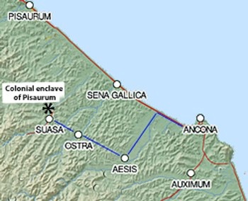
Adapted from the Digital Atlas of the Roman Empire
Blue line indicates the probable route of the road defined in the lapis Aesiniensis
Both Gino Bandelli (referenced below, p. 21 and note 62) and Simone Sisani (referenced below, 2007, at p. 55 and note 156) pointed to the evidence of the production of ceramics on a significant scale at Aesis (Jesi) in the middle of the 3rd century BC.
Many scholars suggest that this might have been the site of a colony founded in 247 BC (discussed below). However, as we shall see, this is unlikely. The earliest certain evidence for a colony here is in the form of the inscription (AE 1990, 0328) on the so-called lapis Aesinensis, which dates to the late 1st century BC. This inscription records that:
-
✴the otherwise unknown Marcus Octavius Asiaticus built a road in honour of the colonies of Ancona, Pisaurum and Aesis; and
-
✴this road, which was partly on his own land and partly on land that belonged to Pisaurum, connected the Via Salaria Gallica to the Via Salaria Picena.
Gianfranco Paci (referenced below) suggested that:
-
“The new road ... connected Ancona, which was on the Salaria Picena, with [Aesis], on the Salaria Gallica, ... and probably continued, northwards from [Aesis] towards Suasa, where ... some of the [veterans] who had been assigned to [Pisaurum] after the battle of Philippi in 42 BC had been settled, [as evidenced by two inscriptions (EDR 016350 and EDR 016351)] from the 1st century AD that marked the boundary of this colonial enclave]” (my translation).
He observed that:
-
“... Ancona became a colony only in 42 BC, while [Pisaurum and, (in his opinion) Aesis] already had this status at that time. [The project undertaken by Octavius Asiaticus] should be understood as the intervention of a munificent benefactor for [veteran] settlers transferred to all three colonies following the civil wars of this period” (my translation).
Paci’s suggestion of a new phase of veteran settlement at Aesis under Augustus is unlikely, since, while Pliny the Elder designated both Ancona (‘Natural History’, 3:18) and Pisaurum as colonies, he did not so-designate Aesis (‘Natural History’, 3:19). Laurence Keppie (referenced below, at p. 5) observed that, according to Pliny himself, the colonies in his list were those so-designated in a list compiled by Augustus. Furthermore, he deduced that these colonies had all:
-
“... achieved that status, or had it renewed, from [Julius] Caesar onwards.”
We know that:
-
✴according to Appian (‘Civil Wars’, 5:23), two legions that had served under Julius Caesar and under Mark Antony had subsequently been settled at the new colony at Ancona in 42 BC; and
-
✴according to Plutarch (‘Life of Antony’, 60:2) Pisaurum, had been re-colonised by Mark Antony at about that time.
However, the evidence of Pliny the Elder suggests that Aesis had received no new colonists in the Caesarian, triumviral or Augustan periods. Indeed, Laurence Keppie (referenced below) made two observations (at p. 184 and p. 100 respectively) that suggest that it had lost territory to Ancona:
-
✴“... by the late Republic, the territory of Ancona was closely confined by the colonies at Sena Gallica and Auximum. ... The testimony of Appian (as above) ... provides the information that two legions were [nevertheless] settled there ...”
-
✴“Two legions were [settled] at Ancona after Philippi: even allowing for some expropriation of land from nearby Aesis and Auximum, the task of accommodating their veterans on flat land [near Ancona] must have been difficult.”
Despite this, the evidence of the lapis Aesinensis suggests that Aesis enjoyed equal status with Ancona and Pisaurum in the late 1st century BC (albeit not in the eyes of Augustus). Later evidence for its colonial status comes in the form of two inscriptions (CIL IX 5831 and CIL IX 5832) from the 2nd century AD, which refer to the magnificently named Marcus Oppius Capitonus Quintus Tamudius Aninius Severus as a patron of two colonies: his native Auximum (Osimo) and Aesis.
Earlier History of Aesis
A Colony Founded in 247 BC ?
Velleius Paterculus recorded that:
-
“At the outbreak of the First Punic War [in 264 BC], Firmum [in Picenum] and Castrum [Novum, probably in Etruria] were occupied by colonies: [other colonies were founded at] Aesernia a year later; [and at] Aefulum and Alsium 17 years later [i.e. in 247 BC] ... ”, (‘History of Rome’, 1: 14: 8).
Some, but not all, scholars follow the hypothesis (1860) of Theodor Mommsen, which identified ‘Aefulum’ or ‘Aesulum’ with Aesis.
However, we should note that:
-
✴Velleius paired Aefulum with Alsium, which was a maritime citizen colony in Etruria; and
-
✴Aefulum was not among the 30 Latin colonies listed by Livy at the start of the Second Punic War.
We might therefore reasonably assume Aefulum it too was a citizen colony. However, as Gino Bandelli (referenced below, at column 22) observed, all the securely-attested citizen colonies that were founded in the 3rd century BC seem to have been maritime colonies, a consideration that militates against the identification of Aefulum with inland Aesis. In the absence of any supporting evidence, the emendation of Aefulum as Aesium/ Aesis should probably be rejected.
A Forum Constituted before 163 BC ?
Simone Sisani (referenced below, 2007, at p. 55) pointed out that one of the prodigies that Julius Obsequens listed for the year 163 BC was potentially relevant to this discussion:
-
“Ad forum Aesi bovem flamma ex ipsius ore nata non laesit”, (‘De prodigiis liber’, 14).
-
“At Forum Aesi, an ox was unhurt by a flame that sprang from its mouth” (my translation).
He suggested that:
-
“The original institutional status of Aesis must have been that of a forum ...” (my translation).
However, Gino Bandelli (referenced below, at column 19 and note 49) noted that the surviving manuscript of Julius Obsequens refers to ‘Forum Essi’, and that this was emended to Forum Aesi, by Friedrich Julius Rosenbach in his edition of 1897: while some scholars accept this emendation, others either propose a different emendation or accept the original manuscript as it stands.
For Simone Sisani (as noted above), the constitution of this forum at Aesisi was a certainty. Furthermore, he suggested that it:
-
“... was probably constituted in 247 BC, as recorded by Velleius, who perhaps [misunderstood the precise information provided by] his source ...” (my translation).
However, this hypothesis relies on the assumption that Vellius had made two mistakes:
-
✴wrongly transcribing Aesis (or, according to Strabo, Aesium) as Aefulum; and
-
✴misrepresenting as colonisation its constitution as a forum in 247 BC.
In my view, this is unlikely: in my view, we can only say that it is possible, but not certain. that a forum had been constituted here by 163 BC.
A Colony Founded in the 2nd Century BC ?
Gino Bandelli (referenced below, at columns 22-3) noted the absence of Aesis from the ‘Liber coloniarum’ (which was compiled in the 4th century AD): according to Saskia Roselaar (referenced below, 2009, at p. 199), the two surviving compilations of this name were based on information in a survey commissioned by the Emperor Augustus (27 BC - 14 AD):
-
“The main aim of the survey carried out at this time was most likely to avoid [a repetition of the] confiscation and violence that had occurred in the triumviral period. To this end, Augustus gathered information on land settlement from the Gracchi [i.e. from ca. 133 BC] until his own period, and organised these by region.”
Bandelli pointed out (at column 23) that, assuming that this list is complete, then the colony of the lapis Aesinensis must have been founded before ca. 133 BC.
-
✴He suggested that it might well have been founded earlier in the 2nd century, when citizen colonies began to be established inland (for example, at nearby Auximum in 157 BC).
-
✴However, at this later date, it might alternatively have been a Latin colony (like Bononia, which was founded in 189 BC, subsequently municipalised, and then re-colonised in the triumviral period).
Conclusion: Status of Aesis before the late 1st century BC
In the light of the archeological evidence mentioned above, above, it seems likely that Aesis was settled before the organised viritane settlement of 232 BC. It was certainly a colony by the late 1st century BC, but it is not possible to be certain about its prior status. All we know is that it was assigned to the Pollia, either on or prior to colonisation.
Praefecturae
As discussed below, both colonial and viritane citizen settlement took place in the region after the conquest. However, given the ever-present threat from the Gauls to the north, much of the land here seems to have remained as ager publicus until at least until the final submission of the Boii in 191 BC. Two developments would have provided an impetus for citizen settlement despite this insecurity:
-
✴the lex Flaminia agraria sponsored in 232 BC by the tribune C. Flaminius (later consul in 223 and 217 BC) provided for further viritane settlement here; and
-
✴the road that Flaminius built as censor in 220 BC connected Rome to Ariminum via Umbria and the ager Gallicus.
As Saskia Roselaar (referenced below, 2010, at p. 45) pointed out there was still enough ager publicus for:
-
✴the foundation of a citizen colony at Pisaurum in 184 BC; and
-
✴viritane settlement near Fanum Fortunae in the Gracchan period (late 2nd century BC).
However, given the significant amount of land that had been confiscated after the conquest, it seems likely that the services of a Roman prefect were needed in the ager Gallicus, at least from 232 BC and quite possibly earlier, albeit that Festus makes no mention of any prefectures in the ager Gallicus.
In order to explore this hypothesis further, successive sections below set out:
-
✴the historical context; and
-
✴the potential evidence at each of the later urban centres in the region.
The final section then offers my conclusions in relation to the possible constitution of prefectures in the ager Gallicus.
Read more:
F. Belfiori (2020), “Roman Colonization, Sanctuaries and Cult in the Middle-Adriatic Area Between the 3rd and 2nd centuries BC”, in:
E. Giorgi et al. (editors), “Boundaries Archaeology: Economy, Sacred Places, Cultural Influences in the Ionian and Adriatic Areas”, (2020) on-line
D. Miano, “Fortuna: Deity and Concept in Archaic and Republican Italy”, (2018) Oxford
F. Belfiori, “Lucum Conlucare Romano More: Archeologia e Religione del ‘Lucus’ Pisaurensis”, (2017) Bologna
P. Davies, “Architecture and Politics in Republican Rome”, (2017) Cambridge
P. L. Dall’ Aglio et al., “Geomorphological and Anthropic Control of the Development of some Adriatic Historical Towns Since the Roman Age”, Quaestiones Geographicae, 36:3 (2017) 111–23
G. Sampson, “Rome Spreads Her Wings: Territorial Expansion Between the Punic Wars”, (2016) Barnsley
R. Syme (author, died in 1999) and F. Santangelo (editor of these papers from the Ronald Syme archive), “Approaching the Roman Revolution: Papers on Republican History”, (2016) Oxford
G. Paci,” Il Lapis Aesinensis e la Scoperta della Salaria Gallica”, (2015) Università di Macerata (online)
I. Pinder, “Augustan City Walls in Roman Italy: their Character and Meanings”, (2015), doctoral thesis from the University of Southampton
G. Lepore, “La Colonia di Sena Gallica: un Progetto Abbandonato?”, in:
M. Chiabà (Ed.), “Hoc Quoque Laboris Praemium: Scritti in Onore di Gino Bandelli”, (2014) Trieste, at pp. 219- 42
M. G. Silani, “Città e Territorio: la Formazione della Città Romana nell' Ager Gallicus”, (2014) doctoral thesis from the Università di Bologna
F. Vermeulen, “Republican Colonisation and Early Urbanisation in Central Adriatic Italy: the Valley of the River Flosis”, in:
T. D. Stek and J. Pelgrom (Eds), “Roman Republican Colonization: New Perspectives from Archaeology and Ancient History”, (2014) Rome, at pp. 141-59
M. Di Fazio, “Feronia: The Role of an Italic Goddess in the Process of Integration of Cultures in Republican Italy”, in
S. Roselaar (Ed.), “Process if Integration and Identity Formation in the Roman Republic”, (2012) Leiden and Boston, at pp. 337-54
E. Giorgi, “Nuovi Dati dagli Scavi di Suasa sulla Genesi e lo Sviluppo dell’ Abitato”, in:
G. de Marinis et al. (Eds), “I Processi Formativi ed Evolutivi della Città in Area Adriatica (Convegno Archeologico, Macerata, 10-11 Dicembre 2009)”, (2012) Oxford, at pp. 345-62
R. Feig Vishnia, “A Case of ‘Bad Press’? Caius Flaminius in Ancient Historiography”, Zeitschrift für Papyrologie und Epigraphik, 181 (2012) 27-45
S. Antolini and S.Marengo, “Regio V (Picenum) e Versante Adriatico della Regio VI (Umbria)”, in
M. Silvestrini (Ed.), “Le Tribù Romane: Atti della XVIe Rencontre sur l’Epigraphie du Monde Romaine (Bari, 8-10 Ottobre 2009)”, (2010) Bari, at pp. 209-15
P. L. Dall’ Aglio and S. De Maria, “Il Territorio delle Marche e l’Adriatico in Età Romana”, Bollettino di Archeologia on line, (2010)
S. Roselaar, “Public Land in the Roman Republic: A Social and Economic History of Ager Publicus in Italy, 396 - 89 BC”, (2010) Oxford
M. Luni et al. ,“Geomorphology and Archaeology: an Integrated Heritage along the Roman Via Flaminia in the mid Metauro River Valley (Central Italy)”, Memorie Descrittive della Carta Geologica d’Italia, 87 (2009), 99-108
S. Roselaar, “ References to Gracchan Activity in the Liber Coloniarum”, Historia: Zeitschrift für Alte Geschichte, 58:2 (2009), 198-214
P. L. Dall’Aglio, “Suasa: Centro di Strada” in:
M. Medri (Ed.), “Sentinum 295 a.C. – Sassoferrato 2600: 2300 Anni Dopo la Battaglia: Una Città Romana fra Storia e Archeologia: Atti del Convegno Internazionale (Sassoferrato 2006)”, (2008) Rome, at pp. 83-90
O. Mei, “The Town of Forum Sempronii (Marche, Italy) and its Relationship with the Contemporary Landscape”, in:
O. Menozzi et al. (Eds), “SOMA 2005 : Proceedings of the IX Symposium on Mediterranean Archaeology, Chieti (Italy) 24-26 February 2005” , (2008) Oxford, pp. 377-82
J. Scheid, “Rome et les Grands Lieux de Culte d’ Italie”, in:
A. Vigourt et al. (Eds), “Pouvoir et Religion dans le Monde Romain: en Hommage à Jean-Pierre Martin”, (2006) Paris, pp. 75-88
S. Sisani, “Fenomenologia della Conquista: La Romanizzazione dell' Umbria tra il IV sec. a. C. e la Guerra Sociale”, (2007) Rome
P. Harvey, “Religion and Memory at Pisaurum”, in:
C. Schultz and P. Harvey (Eds.), “Religion in Republican Italy”, (2006) Cambridge, at pp. 117-36
R. J. Littlewood; “A Commentary on Ovid's Fasti, Book 6”, (2006) Oxford
S. Sisani, “Umbria Marche (Guide Archeologiche Laterza)”, (2006) Rome and Bari
G. Bandelli, “La Conquista dell’ Ager Gallicus e il Problema della ‘Colonia’ Aesis”, Aquileia Nostra, 76 (2005), columns 13-54
P. Ferretti, “Fossombrone: Area Archeologica Forum Sempronii”, in:
"La Valle del Metauro - Banca Dati sugli Aspetti Naturali e Antropici del Bacino del Metauro", edited by the Associazione Naturalistica Argonauta e Comune di Fano, Fano (2004)
F. Giovannini, ‘Il Popolamento Antico nella Media Valle dell'Arzilla: Capitolo 3”, in:
"La Valle del Metauro - Banca Dati sugli Aspetti Naturali e Antropici del Bacino del Metauro", edited by the Associazione Naturalistica Argonauta e Comune di Fano, Fano (2004)
G. Bradley, "Ancient Umbria", (2000) Oxford
T. C. Brennan, “The Praetorship in the Roman Republic: Volume 1: Origins to 122 BC”, (2000) Oxford
B. Campbell, “The Writings of the Roman Land Surveyors: Introduction, Text, Translation and Commentary”, (2000) London
F. Coarelli, “Il Lucus Pisaurensis e la Romanizzazione dell’ Ager Gallicus”, in:
C. Bruun (editor), “The Roman Middle Republic: Politics, Religion and Historiography, ca. 400-133 BC: Papers from a Conference at the Institutum Romanum Finlandiae, September 11-12, 1998”, (2000) Rome, at pp. 195-205
D. Gargola, “Lands, Laws, and Gods: Magistrates and Ceremony in the Regulation of Public Lands in Republican Rome”, (1999) Chapel Hill, North Carolina
R. Laurence, “The Roads of Roman Italy”, (1999) Oxford
A. Trevisiol, “Fonti Letterarie Ed Epigrafiche Per La Storia Romana Della Provincia Di Pesaro E Urbino”, (1999) Rome
R. Feig Vishnia, “State, Society and Popular Leaders in Mid-Republican Rome (241-167 BC”, (1996) Oxford and New York
G. Mason , “The Agrarian Role of Coloniae Maritimae: 338-241 BC”, Zeitschrift für Alte Geschichte, 41:1 (1992) 75-87
P. Fontaine, “Cités et Enceintes de l'Ombrie Antique” (1990) Brussels
A. Eckstein, “Senate and General: Individual Decision-making and Roman Foreign Relations (264-194 BC)”, (1987) Berkeley, Los Angeles and London
N. Alfieri, “La Battaglia del Lago Plestino", Picus, 6 (1986) 7-22
S. Dyson, “The Creation of the Roman Frontier”, (1985), Princeton, New Jersey
L. Keppie, “Colonisation and Veteran Settlement in Italy, 47–14 BC”, (1983) Rome
W. Harris, “Rome in Etruria and Umbria”, (1971) Oxford
E. Salmon, “Roman Colonisation Under the Republic”, (1970) New York
T. P. Wiseman, 'Roman Republican Road Building”, Papers of the British School at Rome, 38 (1970) 122-52
L. Ross Taylor, “The Voting Districts of the Roman Republic: The 35 Urban and Rural Tribes”, (1960) Rome
Return to the History Index