

Prefecture at Interamna Nahars (?)
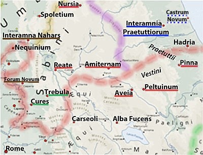
Prefectures in alta Sabina: Nursia, Reate and Amiternum
Prefectures in the territory of the Vestini: Aveia and Peltuinum
Prefectures in the territory of the Praetutti: Interamnia Praetuttorium
Prefectures in Umbria: Interamna Nahars ?
Citizen colony: Castrum Novum (290-86 BC ? 264 BC ?)
Latin Colonies: Alba Fucens (303 BC); Nequinum/ Narnia (299 BC); Carseoli (298 BC);
Hadria (290-86 BC - see below); Spoletium (241 BC)
Underlining indicates tribes: green = Sergia; red = Quirina; blue = Velina; brown = Clustumina
Interamna Nahars (Terni) was included in the Augustan 6th region (Umbria), but was close to a number of Sabine centres, including Reate and Forum Novum. Its Latin name is suggestive: according to Varro:
-
“The town ‘Interamna’ gets its name from its position ‘inter amnes’ (between rivers)” (‘De Lingua Latina’, 5:28).
There were at least three cities that had this name and the associated riverine characteristic:
-
✴Interamna Lirinas, a Latin colony established in 312 BC on the Liris River, which was later destroyed;
-
✴Interamnia Praetuttorium (Teramo - see below), a small Roman conciliabulum between the rivers Tordino and Vezzola, which (as discussed below) was probably also constituted as a prefecture; and
-
✴Interamna Nahars, which was located at the confluence of the Nar (Nera) and the Serra (which has since changed its course).
Thus, we might reasonably assume that Interamna Nahars was essentially of its Roman provenance, an assumption supported by the from of its original walls, which, according to Paul Fontaine (referenced below, at pp. 122-30), had been built using large squared blocks of travertine carefully faced and cut to Roman measures. These walls, which probably dated to the 3rd century BC, enclosed an area of some 35 hectares, which made Interamna Nahars the largest urban area of Roman Umbria.
A Latin Colony or a Prefecture (?)
Scholars (for example three referenced below: Lily Ross Taylor, at p. 85; William Harris, at p. 153; and Michel Humbert, at p. 225) have long believed that the apparently Roman provenance of Interamna Nahars suggested that it had been enfranchised at an early date. However, Guy Bradley (referenced below, at p. 5) argued that it had more probably been founded as a Latin colony. He acknowledged the lack of documentary evidence for this hypothesis, which reliedinstead on the Roman characteristics mentioned above and also on the archeological evidence for its original street plan:
-
“[Paul] Fontaine [referenced below, at p. 121-2] has shown that the walls [of Interamna Nahars] originally enclosed a trapezoidal site of 35 hectares, and that the insulae created by the street pattern were rectangular. These insulae were typical of Latin colonies in the 3rd century BC (such as Cosa in Etruria) ... All this makes it virtually certain that the town was, like Latin colonies, subject to a substantial Roman building programme.”
In relation to the putative date of this foundation, he observed (at p. 6) that:
-
“One obvious possibility is connected with that of [the nearby Latin colony of] Narnia in 299 BC, but Livy's account of [the latter foundation] no support for such a hypothesis. A more plausible date is soon after Curius Dentatus conquered the neighbouring Sabines, to whom Interamna was strongly linked ...”
In short, he believed that the archeological evidence suggested that Interamna Nahars had been founded as a Latin colony, complete with walls and other urban structures, in ca. 290 BC.
Simone Sisani (referenced below, 2007, at pp. 146-50) did not dispute the likely Roman origins of Interamna Nahars, but he asserted (at p. 146) that:
-
“... it is likely that the centre was born as a praefectura in coincidence with viritane settlement [in the surrounding area] in the 3rd century BC” (my translation).
He argued (at p. 146) that, pace Bradley, he archeological record indicated that its walls were initially:
-
“... the only construction work carried out in the area of the future city, which would become urbanised only from the early 1st century BC; the walls represented, at the moment of their construction, a sort of empty shell, destined to welcome a ‘city in waiting’ (città ‘in potenza’”), [which probably functioned initially as]:
-
-the centre of gravity for the sparse population of the territory, for whom it represented, above all, a well-defended fortress and a political and economic centre; and
-
-the seat of activity for the prefects sent from Rome” (my translation).
He also suggested (at p. 147) that Roman Interamna Nahars had been established on what was essentially virgin territory:
-
”The [ancient] settlements that are identifiable on the future site of the urban centre of Interamna ... had all been abandoned by the 6th century BC” (my translation).
Thus, since the Romans needed a centre of some kind here in order to accommodate the activities of the visiting prefects, they had to create it themselves.
In relation to the precise circumstances in which the putative prefecture was constituted, Sisani asserted (at p. 214), that:
-
“... the first viritane deductions in Umbria can be dated to the first three decades of the 3rd century BC, in strict rapport with the conquest and colonisation of the Sabina by Curius Dentatus. A reflection of this activity seems to be the inclusion of Interamna in the Clustumina [see below]. This was also the assignation] of Sabine Forum Novum [medieval Vescovio, modern Torri in Sabina - see the map above], the creation of which is inseparable from the politics of the conquest carried out from 290 BC. If the creation of [the presumably citizen settlement of] Forum Novum should be placed close to this date, it is possible that other contemporary deductions took place at this time in the fertile conca ternana, with the settlers assigned to the same tribe as their contemporaries in the adjacent Sabine lands: the putative praefectura of Interamna would have been created at this time” (my translation).
My View
The first point to make is that the two hypotheses above are not mutually exclusive: there is no reason why a Roman prefect could not have had his seat in a Latin colony sited within the jurisdiction of his prefecture. I am not aware of any evidence for any other Latin colony at which this was the case, but it might well have applied, for example, at the Roman colony of Saturnia in Etruria.
However, Guy Bradley’s hypothesis of a Latin colony at Interamna Nahars relies exclusively on the evidence of its orthogonal street plan. In fact as Laura Bonomi Ponzi (referenced below, at p. 12) pointed out in the context of modern Foligno:
-
“... the regularity of an urban plan is inconclusive proof of Roman origins[of any kind] if it is not supported by concrete archeological evidence” (my translation).
In the case of Interamna Nahars, Simoni Sisani (referenced below, 2007, at p. 146) pointed out that there is no surviving archeological evidence for a substantial Roman building programme that accompanied the construction of its first circuit of walls. He also cited (at p. 148) a precedent for this at the nearby prefecture of Reate (as discussed above):
-
“The circuit of walls at this Sabine centre presents close analogies with those at Interamna Nahars, in both their technical aspects and the adoption of Roman [measures: furthermore, as at Interamna Nahars,] the walls [at Reate] seem to represent the only urban initiative of any significance [undertaken here] until well into the 1st century BC ...” (my translation).
Thus, in the absence of any other evidence for a Latin colony at Interamna Nahars, I think that this possibility must be discounted, particularly since, when the walls of Interamna were built early in the 3rd century BC, there was already the Latin colony of Narnia, only about 13 km away.
On the other hand, the parallels between Interamna Nahars and Reate are surely significant. Simone Sisani (above) highlighted the similarities in the archeological evidence from both sites. In addition, as Guy Bradley observed, both Reate and Interamna Nahars would have been significantly affected by the draining of the lacus Velinus under the auspices of Curius Dentatus in ca. 270 BC:
-
✴He observed (at p. 10) that:
-
“In order for the low-lying conca ternana to be used for colonial land distributions, measures will have been needed to control its sometimes overabundant water supply. This must have been especially important after 272 BC, when M' Curius Dentatus created an emissary for the water of the lacus Velinus to drain, via the spectacular Cascate delle Marmore, into [this plain]. Fontaine [referenced below, at p. 27] has argued plausibly that adequate drainage measures must have already been in place by this point to cope with the excess water produced.”
-
The same consideration would have applied in the case of a prefecture constituted at Interamna Nahars in association of viritane settlement in the conca ternana.
-
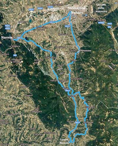
✴He also suggested (at p. 6) that, soon after the conquest by Curius Dentatus, it is possible that:
-
“... Interamna was connected to Reate by the Via Curia.”
-
The existence of this road is indicated by Dionysius of Halicarnassus:
-
“At the distance of 80 stades from Reate, as one goes along the Curian Way past Mount Coretus, stood Corsula, a town but recently destroyed”, (‘Roman Antiquities’ 1: 14: 4).
-
This road was presumably built by Curius Dentatus after the draining of the lacus Velinus. According to Paolo Camerieri and Andrea De Santis (referenced below, at p. 59), the study of the centuriation near Reate, which they assumed was the work of the land surveyors of Curius, suggested that:
-
“... for a long period of time, at least until the Lombard period, [this road] retained its importance as a direct link between the two most important opposing sides of the valley [of the Velinus], namely:
-
•the point of arrival of the via Salaria at Reate; and
-
•the point of exit from the valley towards Interamna Nahars.
-
Basically it was the road that connected Rieti and Terni” (my translation).
-
They summarised (at p. 61) as follows:
-
“It is possible ... that the idea of Curius Dentatus was to connect:
-
•Rome, Cures, Trebula Mutuesca and Reate through the Salaria; and
-
•Reate, Interamna Nahars and the Umbrian centres through the Curia” (my translation).
It seems to me that, in all probability, Reate and Interamna Nahars developed in tandem in association with an extensive programme of viritane settlement that had been facilitated by the draining of the lacus Velinus in ca. 272 BC. In my view, this strongly suggests that Interamna, like Reate, was constituted as a prefecture at about this time.
This brings us to the tribal assignation of Interamna Nahars: as William Harris (referenced below, at p.338) observed, its assignation to the Clustumina is:
-
“... supported by numerous local inscriptions and contradicted by none.”
As Simone Sisani pointed out (above), it shared this assignation with nearby Forum Novum: he cited Lily Ross Taylor (referenced below, at pp. 83-4), who observed that Forum Novum was situated:
-
“ ... some 20 miles to the south of Terni, [and was] an old market place on a small tributary of the Tibur. The site ... had road connections with Narnia, through Otriculum, and with Interamna, Reate and Cures. The territory seems to have consisted of a number of settlements between the Tiber and the Nar. An inscription with the Clustumina tribe [the funerary inscription (CIL IX 4763a) , which dates to the 2nd half of 1st century BC] was preserved at Stroncone, about 5 miles south of Interamna. The close relations [within this territory] are obscured by the fact that [it was split between two] Augustan regions, the fourth and the sixth. ... Like the territory of Cures, the site of Forum Novum was probably occupied during the Roman campaigns that ended with the fall of Nequinum in 299 BC and the foundation of the Latin colony of Narnia on the site.”
There is (pace Sisani) no archeological evidence to suggest that Forum Novum itself was constituted as early as 299 BC: Gary Farney and Giulia Masci (referenced below, at p. 552) characterised it as:
-
“... a town that appears (organically ?) in the upper Sabina tiburina, perhaps in the 2nd century BC.”
Nevertheless, it is entirely possible that land in the conca ternana (between modern Narni and Terni) was confiscated in 299 BC, on the fall of Nequinum and the foundation of Narnia. If we accept the parallel development of Reate and Interamna Nahars, it is possible that settlement began here after ca. 272 BC, and that Curius intended to assign these settlers to a new tribe that he intended to designate as the Velina. If so (on the model of tribal assignations in the Sabine lands summarised above) the plan would not have survived Curius’ death in 270 BC, and the censors of 268 BC, who assigned Cures and Trebula to the existing Sergia tribe, might well have assigned Interamna Nahars and the settlers in the surrounding territory to another existing tribe, the Clustumina.
A number of inscriptions from Interamna Nahars, the earliest of which (CIL IX 4210) dates to the second half of the 1st century BC, indicate that it was a ‘normal’ municipium administered by quattuorviri after the Social War. Traditional scholarship attributes this magistracy almost exclusively to centres that had been newly enfranchised after the Social War. Thus, as Guy Bradley pointed out (at p. 8):
-
“If Interamna was a Latin city before the Social War, as the archaeological evidence [in his view] suggests , we would have a straightforward explanation of why it was later governed by quattuorviri, just as Spoletium [for example] was in the late Republic.”
However, as Bradley himself pointed out (at p. 9), pace the received wisdom, the presence of the quattuorvirate does not always indicate centres that were enfranchised only after the Social War: for example, the prefecture documented at Fulginia (see below) seems to have been a ‘normal’ quattuorviral municipium in the 70s BC, and had probably achieved this status soon after the Social War. Thus, the presence of the quattuorvirate at Interamna Nahars in the late 1st century BC does not (as Bradley himself recognised) preclude it from the status of a prefecture before the Social War.
[See Bispham, p. 323]
Incorporation into the Roman State
From the above account, it is clear that:
-
✴Narnia and Spoletium were Latin colonies from the time of the conquest;
-
✴Forum Flaminii was a Roman settlement established in 220 BC;
-
✴Fulginia became a Roman praefectura, probably in the early 2nd century BC and certainly before the Social War (90 BC).
There is some evidence to suggest that the following were established as Roman praefecturae:
-
✴Interamna Nahars, in the period 290-70 AD;
-
✴Nursia (Norcia), in the late 2nd century BC; and
-
✴Plestia, perhaps in the early 1st century BC.
At the other end of the spectrum:
-
✴Ocriculum (Otricoli) probably remained independent, with its relations with Rome governed by a bilateral treaty that ratified the sponsio (promise given in battle) secured in 308 BC;
-
✴Iguvium (Gubbio) certainly secured a bilateral treaty with Rome, probably in the first half of the 3rd century BC; and
-
✴less clear-cut evidence supports the hypotheses that Ameria (Amelia) and Tuder (Todi) retained their independence, presumably subject to bilateral treaties, until the Social Wars.
The evidence is presented in the pages on the history of the respective cities.
Read more:
G. Farney and G. Masci, “The Sabines”, in:
G. Farney and G. Bradley (Eds), “The Peoples of Ancient Italy”, (2018) Boston and Berlin, at at pp. 543-58
P. Camerieri and A. De Santis, “La Via Curia”, in:
R. Cascino and V. Gasparini (Eds), “Falacrinae: Le origini di Vespasiano”, (2009) Rome, at pp. 59-61
S. Sisani, “Fenomenologia della Conquista: La Romanizzazione dell' Umbria tra il IV sec. a. C. e la Guerra Sociale”, (2007) Rome
G. Bradley, “The Colonization of Interamna Nahars', in
A. Cooley (Ed.), “The Epigraphic Landscape of Roman Italy” (2000) London, pp. 3-17
L. Bonomi Ponzi, “Inquadramento Storico-Topografico del Territorio di Foligno”, in:
M. Bergamini (Ed.), “Foligno: La Necropoli Romana di Santa Maria in Campis”, (1998) Perugia, pp. 11-18
P. Fontaine, “Cités et Enceintes de l'Ombrie Antique” (1990) Brussels
M. Humbert, “Municipium et Civitas sine Suffragio: L' Organisation de la Conquête jusqu'à la Guerre Sociale”, Publications de l'École Française de Rome, 36 (1978)
W. Harris, “Rome in Etruria and Umbria”, (1971) Oxford
L. Ross Taylor, “The Voting Districts of the Roman Republic: The 35 Urban and Rural Tribes”, (1960) Rome
Return to the History Index