
Excursions on Monte Serrasanta
To the Sorgente della Rochetta
From Rocca Flea, take Via della Rocca, turn right along Via Angelo Pennoni and fork left along Via Zoccolanti (CAI 208). The “primum castrum Gualdi” (the first walled settlement of Gualdo) was built here in ca. 1208. This settlemnt burned down in ca. 1237 and was rebuilt on its current site.
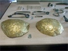
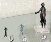
Follow the path (CAI 208) along the gorge (Gola della Rocchetta), with the slope of Monte Serrasanta on your left. The Museo Archeologico, Perugia contains a hoard of ancient objects that was discovered beside this path in the early 1930s. In an article of 2012 in “Il Nuovo Serrasanta” (page 4), Augusto Bossi recalled how he made the discovery as a young boy of 7 0r 8. His father kept the objects for a while before showing them to a local historian, Ruggero Guerrieri, who promptly bought them. They fortunately found their way to the archeological collection of Perugia (by what means, Signor Bossi did not know, but most probably donated by Ruggero Guerrieri).
After about 300 meters, CAI 208 joins the asphalt road through the old plant that was used for the bottling of Gualdo's famous mineral water and continues to its source, the Sorgente della Rocchietta.
[You might want to continue along the CAI 208 for a little way, passing two caves: the Grotta della Coda del Diavolo (cave of the Devil’s tail); and then the Grotta di Frate Fava. St Francis allowed Brother Fava to leave the hermitage you visited above in ca. 1221 and to live in isolation “subtus heremitorium Campitellae” (under the hermitage of Campitella). This cave is clearly associated with these events.]
Return to the Rocca Flea, where the walk ends.
To San Facondino and Colle i Mori
Leave the city by Viale Don Bosco [Porta di San Facondino??] and fork right along Viale dei Cappuccini.
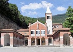
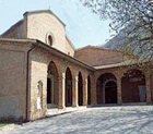
Santa Maria del Divino Amore Eremo del Beato Angelo
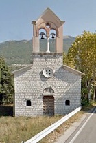
After about 1 km, you reach the Sorgenti di Capodacqua, which was once the site of the now-demolished Erermo di SS Gervasio e Protasio. However, you can still see the Capuchin church and convent of Santa Maria del Divino Amore and the adjacent Eremo del Beato Angelo.
The next part of the walk involves an area that is of great archeological interest:
-
✴Continue along the asphalt road, which becomes Via Raoul Braccini. Take a short detour along Via Ugo Righi Vittore on the left leads to the modern Via Flaminia. Via delle Cartiere gave its name to the ancient le Cartiere necropolis, which was excavated here. The excavations also uncovered a Lombard cemetery and traces of a contemporary structure that was probably the original church of San Facondino
-
✴The road continued to present church of San Facondino, just before the cemetery. This was the site of the necropolis of San Facondino, which served the late Bronze Age settlement at the top of the hill (see below).
Some of the finds from these two Umbrian necropoles and the Lombard cemetery are in the Museo Civico.
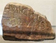
The Strada dei Santi (path CAI 218) starts here, with the first station of the Via Crucis. When you reach the 3rd station, you have reached the Troscia del Colle i Mori. A signed left turn takes you to the site of the excavations of the late Bronze Age settlement and sanctuary. A few votive bronzes from this sanctuary are exhibited in the Museo Civico, together with a cippus (4th century BC) that contained an Umbrian inscription that can probably be translated as “I am here as the limit of the Tadinate community”.
Return to the Troscia del Colle i Mori and descend to San Guido. Follow the provincial road 239 back to Rocca Flea.
(If you want to walk to the Eremo Serrasanta from the summit of Colle i Mori, continue along CAI 218. The walk San Facondino to the summit will apparently take 9 hours return. The alternative is to drive, as described below))
To the Summit of Monte Serrasanta
Unless you are very fit, you will want to do this excursion of some 20 km return by car. (If you want to walk, see the extension to the walk from San Facondino to Colle i Mori above).
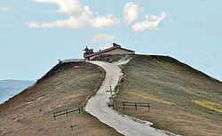
From Rocca Flea, Via Valsorda winds for some 6 km up Monte Serrasanta, past the Rifugio della Madonnuccia, which the Salesians erected in 1914 in honour of Santa Maria Ausiliatirce.
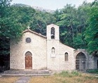
Take a sharp right turn along the Valsorda Pass, where prehistoric remains have been found, to the Eremo di Serrasanta.
Both the drive and the alternative walk are illustrated in this interesting website.
To Tadinum
This walk of some 10 km takes about 3 hours.
The first part of it takes you from the present church of San Benedetto in Piazza Martiri della Libertà to the probable site of the Abbazia di San Benedetto Vecchio. (The monks from the latter moved to the former in 1256).
Return to Via del Biancospino. The stream of the Flea runs in a ditch along its far side and the houses opposite are the Case Pomaiola. The site of the Abbazia di San Benedetto Vecchio was between these houses and Santa Maria di Rote.
Continue along Via del Biancospino, following it under the railway line, and then turn left at the roundabout and walk under the railway line for a second time. Walk straight ahead through fields, crossing two intersections and passing the tiny church of Sant’ Ippolito. The road then becomes the CAI 245/7, which roughly follows the line of the Roman Via Flaminia to the frazione of Sant’ Antonio di Rasina:
-
✴the excavations of the site of Roman Tadinum are on the right, just before you reach the village; and
-
✴the necropolis of Malpasso was excavated in the 1920s on a nearby site on the opposite side of the road. Some of the finds from this necropolis are in the Museo Civico.
Continue along the path and follow it to the left along the railway line. Continue along what is now CAI 245 to Rigali. Cross the main road (SR3) and continue along the CAI 245 as it then turns left, towards Gualdo Tadino. Pass the junction with CAI 243 on the right and continue [to San Martino].
A short detour to the left here takes you to the main road. Turn right: Santa Maria del Piano is a little further along on the right.
Retrace your steps and continue along CAI 245. Fork right ahead and then turn right along Via della Pineta, passing San Rocco.
Continue to the end of Via Pineta, turn left along Viale Roma and immediately right long Via Borgovalle. Continue onto Via Franco Storelli and turn left along Corso Italia to return to Piazza Martiri della Libertà, where the walk ends.
Return to Walk and Excursions.