

Archeological Record
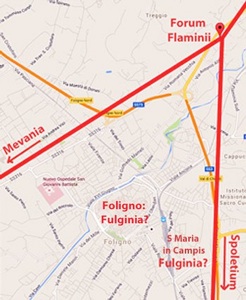
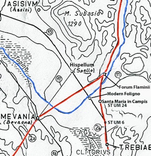
Diagram of western and eastern branches of Via Flaminia (in red),
in relation to the possible sites of Fulginia
We know that a Roman city called Fulginia existed, at least from the time of Cicero (see below). However, we know very little about its history after the Roman conquest of ca. 300 BC, a problem that is compounded by the fact that there is no secure evidence for its location.
The matter of the likely location of Roman Fulginia has been hotly debated since at least the 1930s:
-
✴Michele Faloci Pulignani (in a publication of 1936, quoted by Paola Guerrini and Francesca Latini, referenced below, at p. 75, note 291) observed that:
-
“The land on which our city of Foligno was built is virgin land and, however extensively it is excavated, ... important remains of ancient buildings ... are never brought to light. In contrast, every time one moves the earth near the church of Santa Maria in Campis , one finds ancient objects of all kinds ...” (my translation).
-
Thus, he believed that Roman Fulginia had been located, not on the “virgin soil” of medieval and modern Foligno, but in what is now the suburban area around Santa Maria in Campis, a kilometre from the modern city, on the eastern branch of Via Flaminia (to the lower right in the plan above).
-
✴Giovanni Dominici (referenced below), whose work was broadly contemporary with that of Michele Faloci Pulignani, reached a very different conclusion: he placed Fulginia on the site of the modern city. In particular, he argued (at p. 38) that:
-
“... the four .... bridges [over the Topino in its original course, which ran through the medieval city until its diversion northwards) cannot be later than the 1st century [BC] .... they fill a large lacuna in the history of the city: the existence of all four along a short stretch of a small river like the Topino ... proves that, from the time of the late Republic, there existed at this point a notable Roman city on the edge of a vast marshy area in the central valley of Umbria” (my translation).
-
He offered further evidence for this hypothesis (at p. 39):
-
“[A large part of] the plan of the modern city clearly reflect the traces of an ancient Roman camp: ... [all these features] combine to demonstrate this [hypothesis] in full ...” (my translation).
Modern Scholarship on the Site of Fulginia
Santa Maria in Campis
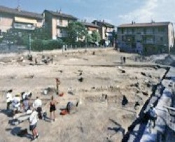
Piazza del Risorgimento, in the area of Santa Maria in Campis during excavations in 1998
(Photograph from Museo Archeologico, Palazzo Trinci)
It is probably fair to say the the view of Michele Faloci Pulignani (above) represented the scholarly consensus for some 80 years, despite the fact that the archeological record at Santa Maria in Campis is essentially non-existent before the 1st century BC. Thus, Paul Fontaine (referenced below, 1990, at pp. 358-9) located Fulginia here, albeit with the following qualification:
-
“At the present state of research, this settlement does not seem to have developed fully until the 1st century AD. [Its] topography ... remains obscure. ... The principal axes of its roads and its forum remain to be discovered. Also, the exact boundaries of the settlement remain fluid ...” (my translation).
Other scholars commented on the lack of secure archeological evidence for the public buildings and public spaces that normally characterise Roman cities.
Reservations of this kind intensified in 1998, when 22 burials from the 1st century BC and early 1st century AD were excavated along a Roman road in Piazza del Risorgimento (at the lower right in the photograph above), at the centre of the area in which Fulginia was supposed to have existed. This has not completely undermined the hypothesis: for example, Paola Guerrini (in Guerrini and Latini, referenced below, at pp. 70-1) was of the opinion that:
-
“... the surviving Roman remains here indicate an area in which to locate the Roman city [of Fulginia], albeit with a certain margin of error regarding their [exclusively residential or funerary] nature” (my translation).
She concluded (at p. 71) that, on the basis of the totality of evidence from the area:
-
“.... it is possible to argue:
-
•[either] that the [archeological] finds to date relate to the peripheral zone [of Roman Fulginia] and its immediate suburbs;
-
•[or] that Fulginia experienced a non-concentrated pattern of urbanisation” (my translation).
Foligno
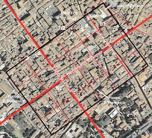
Plan of the Roman castrum proposed by Paolo Camerieri, superimposed on an aerial view of Foligno
Adapted from P. Camerieri (referenced below, 2015, p. 94, Figure 1)
I have added the locations of Roman remains (1-9) and of two possibly Roman burial sites (B1 and B2)
Giuliana Galli and Paolo Camerieri have recently revived and refined the ideas put forward by Giovanni Dominici (above) in a series of articles in two books (referenced below, 2015 and 2016). For example, Paolo Camerieri (referenced below, 2015, at p. 75) began this paper by reasserting the view that:
-
“ ... a glance at the street plan of [Foligno] or, better still, at an aerial photograph, is sufficient to arouse in any scholar of ancient urban topography the well-founded suspicion that [the hypothesis of its Roman origins] is more than likely to be correct ...” (my translation).
He identified (at p. 81) the deCumaenus maximus and cardo maximus of this putative Roman city as well as a second cardo to the northeast, which suggested the canonical plan of a Roman castrum. His observations in this respect were broadly consistent with those of Dominici, except that Camerieri reversed the identifications of the two cardines (as in the plan above).
However, as Laura Bonomi Ponzi (referenced below, at p. 12) pointed out:
-
“... the regularity of an urban plan is inconclusive proof of Roman origins if it is not supported by concrete archeological evidence” (my translation).
In other words, in order to establish the Roman origins of the modern city beyond doubt, we need evidence for buildings with Roman foundations located on its orthogonal plan. It is true that:
-
✴there are a number of Roman elements (which I have numbered 1-9 in the plan above):
-
•in and near the Duomo; and
-
•incorporated into buildings in and near Via Gramsci (along the northwestern boundary of the putative castrum); and
-
✴some of these elements suggest public rather than purely residential or funerary structures:
-
•a possible temple near the Duomo (see, for example, Giuliana Galli, referenced below, 2106, at pp. 98-107); and
-
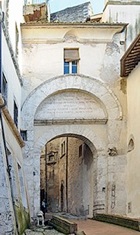
•a possible triumphal arch, fragments of which might have been incorporated into a medieval gate at location 7 (see, for example, Fabio Pontano’s ‘Discourse’ (1618), which has been edited by Luigi Sensi (referenced below, 2008), recorded (at pp. 42-3).
Unfortunately, with the possible exception of the blocks used in a tower that was later incorporated into Palazzo Piermarini (location 3) and blocks that can be seen at pavement level in Via Pertichetti (location 5), none of the associated Roman structures survive in situ. In other words, we have little or no evidence of the kind that Laura Bonomi Ponzi (for example) deemed essential for the identification of the site of a Roman city. There is also some archeological evidence that potentially militates against this putative Roman city, in the form of a number of gabled-tile graves that were apparently found:
-
✴in front of the main facade of the Duomo (marked B1 in the street plan above) in 1900; and
-
✴in Via Cairoli (B2), part of the putative cardo maximus, in 1889.
As I understand it, gabled-tile burials are known as early as the 5th century BC and they continued in use, particularly in poorer communities, into the Middle Ages [references needed]. However, many scholars suggest that these graves in Foligno were Roman, noting that burial would not have taken place within the boundaries of a Roman city: see, for example, Bernardino Lattanzi (referenced below, at p. 72 and Figure 13) who assumed that these were Roman burials and disqualified modern Foligno as a candidate for the location of Roman Fulginia on this basis.
In other words, the evidence that survives within the boundaries of the putative Roman castrum does not take us very far in either direction (which probably explains why the debate has continued for so long). However, Giuliana Galli and Paolo Camerieri have recently added a new item to the agenda: the topographical context within which the putative Roman city at Foligno was located. I discuss this below in the light of the other evidence at our disposal relating to the history of Roman Fulginia.
Documentary Record
Unfortunately, the documentary record of Fulginia before the Social War does little to resolve the significant gaps in our understanding: as Paul Fontaine (referenced below, at p. 358) pointed out:
-
“... [Fulginia] does not appear in ancient texts before the 1st century BC” (my translation).
One author, Silius Italicus (see below), confidently recorded its existence in the late 3rd century BC but, as we shall see, little reliance can be placed on his testimony. Fortunately, Cicero also documented the city, in a speech that he delivered just after the Social War, and this provided our one reasonably secure reference to its existence in the prior period.
Silius Italicus
According to Silius Italicus, the Umbrian towns that sent soldiers to reinforce the Romans at the Battle of Cannae (216 BC) in the early stages of the Second Punic War included:
-
“... Fulginia, which stands unwalled on the open plain, ...” (‘Punica’, 8:458).
Paul Fontaine (referenced below, at pp. 359-60) observed that:
-
“We do not know whether [the statement that Fulginia was a discrete, albeit unwalled, settlement] pertained to the time of the composition of the poem (the end of the 1st century AD) or to the time of the Second Punic War” (my translation).
In fact, we might consider a more fundamental point: nothing else in the surviving literature confirms the existence at of a town called Fulginia, whether walled or unwalled, at the time of Hannibal’s invasion. While we cannot rule out the possibility that Silius had a now-lost source for Fulginia’s participation in this war, he was, as Guy Bradley (referenced below, at pp. 196-7, note 21) pointed out:
-
“... a notoriously unreliable source for this type of information.”
It is therefore more likely that he simply exercised poetic licence in respect of the unwalled city that he knew in the 1st century AD.
This hypothesis is supported (in my view) by another passage from this poem, which reports that, during the earlier battle at Lake Trasimene (217 BC), Hannibal had killed:
-
“... the luckless Varenus of Mevania, ... for whom fertile Fulginia ploughed her rich soil ...” (‘Punica’, 4:546).
As Ronald Syme (referenced below, at p. 276) observed, this passage demonstrates that:
-
“... Silius could come out with an authentic and impeccable Umbrian name if he wanted to: [for example, he has] a warrior who was killed at the Battle of Lake Trasimene called Varenus Mevanas, who possessed rich lands in the plain of Fulginia. The invention [of this name] avows the literary scholarship of Silius and the educated reader would take the reference to Cicero’s speech ‘pro Vareno’ [see below]” (my bold italics).
This page in the excellent website ToposText also has links to both of these references from Silius Italicus.
Cicero
The earliest surviving documentary reference to Fulginia comes in Cicero’s speech ‘pro Vareno’. Unfortunately, the speech itself no longer survives, but its substance can be at least partially reconstructed from surviving testimonies and fragments. Jane Crawford (referenced below), who has collected and commented upon the surviving information (at pp. 7-18), tentatively dated the trial to the period 77-6 BC (see p. 9). The speech was made in defence of Lucius Varenus, who was charged with the murder of two of his relatives and the attempted murder of a third. If Ronald Syme is correct in his comment on Silius Italicus (above), then this poet had learned from this speech that Varenus came from Mevania and owned land in the territory of nearby Fulginia.
We know from Quintilian that:
-
“... in the ‘pro Vareno’, [Cicero tried to divert] the charge from the accused to the slaves of Ancharius [Rufus]” (‘Institutio Oratoria’, 7:2:10).
The surviving references by Cicero to Fulginia come in two fragments of the speech that were commented on by Priscian, whose book on Latin grammar was written in ca. 500 AD:
-
“Cicero ‘pro Vareno’: «G(aius) Ancharius Rufus fuit e municipio Fulginate»:
-
idem in eadem: «in praefectura Fulginate»”
-
(‘Institutiones Grammaticae: de Nomine’ 2:348, 18-20, search on “Fulginate”);
which I translate as:
-
“Cicero, in ‘pro Vareno’: «G(aius) Ancharius Rufus was from the municipium of Fulginia; and, in the same work: «[something of relevance occurred] in the prefecture of Fulginia”.
As discussed below, many scholars suggest that Fulginia was a municipium at the time of the trial, but that some of the events that were relevant to it had taken place at a time when it had been a Roman prefecture. However, this is not necessarily correct: for example, according to Edward Bispham (referenced below, at p. 472), these fragments suggest that Fulginia was :
-
“... a municipium, but still subject to a [prefect] in the early 1st century BC.”
Pliny the Elder
Pliny the Elder (‘Natural History’, 3:19), included the Fulginates in his list of the peoples of Umbria who were assigned to the Augustan Sixth Region. We can therefore reasonably assume that Fulginia had been constituted as a municipium by ca. 7 BC, the date of Augustus’ administrative reform of Italy.
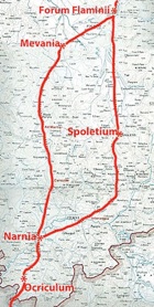
Via Flaminia (220 BC)
-
✴the eastern branch passed through Spoletium (Spoleto); and
-
✴the western branch passed through Mevania (Bevagna).
These two branches probably converged at Forum Flaminii (slightly north of modern Foligno) before continuing across the Apennines to Rimini (Ariminum) on the Adriatic coast.
There is some doubt about the precise date at which the road was built:
-
✴Festus recorded that:
-
“The Circus Flaminius and the Via Flaminia are named for the consul Flaminius, who was killed by Hannibal [in 217 BC] beside the Lake of Trasimene” (‘De verborum significatu quae supersunt cum Pauli epitome’, my translation).
-
This is sometimes taken to imply that Flaminius built the road when he was consul for the first time (i.e., in 223 BC). However, it seems more likely that Festus was simply using the consulship to identify the particular Flaminius about whom he was writing.
-
✴Livy was more specific about the date of the road: according to the Periochae (summary) of Book 20 of his ‘History of Rome’, Flaminius built it in 220 BC, when he held the post of censor.
I have followed Livy’s dating in what follows.
Dates of the Respective Branches in Umbria
The earliest surviving record of the route of Via Flaminia in Umbria was written by Strabo in 7 BC:
-
"The [Umbrian] cities ... on the Flaminian Way itself [are]:
-
✴Ocricli [Otricoli], near the Tiber;
-
✴Narnia [Narni], through which the Nar River flows ... ;
-
✴Carsuli [now the archeological site known as Carsulae]; and
-
✴Mevania [Bevagna] ... ;
-
... [together with] other settlements [on this road] that have become filled up with people on account of the Way itself rather than of political organisation; these are:
-
✴Forum Flaminium [Forum Flaminii]; and
-
✴Nuceria [Nocera Umbra] …
-
Secondly, to the right of the Way, as you travel from Ocricli to Ariminum, are:
-
✴Interamna [Terni];
-
✴Spoletium [Spoleto]; and
-
✴Aesium [Assisi] …
-
On the other side of the Way [are]:
-
✴Ameria [Amelia];
-
✴Tuder [Todi] (a well-fortified city);
-
✴Hispellum [Spello]; and
-
✴Iguvium [Gubbio], the last-named lying near the passes that lead over the mountain” (‘Geography’, 5: 2:10).
Since Strabo located:
-
✴Carsulae and Mevania “on the Flaminian Way”; and
-
✴Interamna and Spoletium “to the right of the Way”;
he clearly regarded only the western route across Umbria as part of Via Flaminia.
This was also the case for the four versions of the Itinerarium Gaditanum, (itinerary from Gades (Cadiz) to Rome) that were inscribed on the so-called Vicarello Cups at different periods around the 1st century AD: the road in Umbria ran through:
-
✴Helvillo [Fossato di Vico];
-
✴Nuceria [Nocera Umbra];
-
✴Mevania [Bevagna];
-
✴Ad Martis [outside Massa Martana];
-
✴Narnia [Narni];
-
✴Ocriclo [Otricoli]
In view of these early itineraries, scholars (see, for example, Ronald Syme, referenced below, at p. 287 and Paolo Camerieri, referenced below, 1997, at p. 37 et seq.) assume that only the western branch of the road formed part of Flaminius’ project. Paolo Camerieri suggested (at pp. 64-6) that the eastern branch was not paved until nearly a century later, after the further drainage of the area near Terni, perhaps in association with the viritane settlement carried out in ca. 122 BC under the auspices of Gaius Sempronius Gracchus
Paul Fontaine (referenced below, at p. 38) pointed out that:
-
“Although [the eastern branch] was [in his view] officially more recent, the other route [while not yet officially designated as the Via Flaminia] must certainly have been in service from the 3rd century BC in order to ensure the link with the colony of Spoletium, which was founded in 241 BC” (my translation).
Guy Bradley (referenced below, at p. 144, note 146) made the same point. Both Fontaine and Bradley clearly assumed that the account of Strabo proved that, while a road from Narnia via Spoletium to Forum Flaminii existed in 220 BC, it was not initially designated as part of Via Flaminia.
However, as Simone Sisani (referenced below, 2007, at p. 124-5) pointed out, Strabo’s account (our earliest surviving source) was not written until some 200 years after Flaminius’ death. He argued that:
-
✴Flaminius’ road had more probably originally followed the eastern route, through the important colony at Spoletium;
-
✴an Umbrian inscription (ST UM 6, late 3rd century BC BC) that was found at San Pietro di Flamignano, on the eastern branch of Via Flaminia (see below) was probably associated with the opening of this branch of the road; and
-
✴Hannibal had almost certainly marched along this road after his victory at Lake Trasimene in 217 BC, since his march on Rome was apparently only halted when he arrived outside the walls of Spoletium (see below).
For Sisani (at p. 126), the western branch was the later branch:
-
“... that could date back to the activities of [Gaius Sempronius Gracchus], who was directly involved in road-building. This activity ... could have been related to the foundation of [the colony of] Forum Sempronii (modern Fossombrone) on Via Flaminia [following the lex Sempronia of 133 BC]” (my translation).
My View
I find Sisani’s arguments for the hypothesis that the eastern branch of the road formed part of the Flaminius’ project persuasive, and can see no basis for the assertion of Fontaine (followed by Bradley) that, although it had existed from 241 BC, it was not formally incorporated into Flaminius’ project. However, neither can I see any basis for Sisani’s assertion that the western branch must have been a later development. In my view, in the absence of hard evidence to the contrary, we must assume that Flaminius built both branches of Via Flaminia (as evidenced by the fact that he established Forum Flaminiiat the point at which they converged before crossing the Apennines).
It is surely important to bear in mind that Strabo was writing some 20 years before the Emperor Augustus restored Via Flaminia at his own expense. It is at least possible that this branch was privileged in Augustus’ restoration:
-
✴The magnificent Ponte d' Augusto, which took the western branch of the road over the Nera, was almost certainly built as part of this project.
-
✴An important side road beyond Mevania connected Via Flaminia to Hispellum (Spello): as discussed in the following page:
-
•Augustus (while still Octavian) had established a colony here in 40 BC;
-
•he probably provided it with its impressive walls at the time of his restoration of Via Flaminia; and
-
•he probably financed the magnificent pan-municipal sanctuary below these new walls as part of the same construction project.
In other words, the western branch might have emerged as the major branch only after the restoration of 27 BC, which might well account for the way it was represented both by Strabo and the Itinerarium Gaditanum.
Later Itineraries and the Location of Fulginia
Itinerarium Antoninum
The Itinerarium Antoninum is a collection of itineraries along the roads of the Roman Empire, which includes the stopping places and the mileage between them. It was probably commissioned by the Emperor Caracalla in the early 3rd century AD, albeit that the surviving copies seem to date to the early 4th century AD. According to Paolo Camerieri (referenced below, 2015, at p. 75):
-
“... on the basis of a census of the urban centres of the Empire and the distances between them along the principal thoroughfares ....” (my translation).
Richard Talbert (referenced below, 2007, at p. 256) gave a more nuanced view:, describing a broad consensus that
-
“... it assembles individual itineraries of distinctly varied character and perhaps even date, [and that] it was compiled around 300 AD ...”
Nevertheless, Camerieri is surely correct that official information underlay the parts of the itinerary that coincide with the great consular roads, including the Via Flaminia.
The itinerary included both the western branch (reproduced in this website at location 311), under the heading ‘Flaminia’, which passed through;
-
✴Utriculi [Otricoli]
-
✴Narniae [Narni)] mpm XII
-
✴Ad Martis [outside Massa Martana] mpm XVIII
-
✴Mevaniae [Bevania] mpm XVI
-
✴Nuceriae [Nocera Umbra] mpm XVIII;
-
✴Helvillo vicus [Fossato di Vico] mpm ?
and, for the first time in our surviving sources, the entire eastern branch (reproduced in this website at location 125), which passed through:
-
✴Utriculi civitas
-
✴Narnia civitas mpm XII
-
✴Interamnia civitas [Terni] mpm VIII
-
✴Spolitio civitas [Spoleto] mpm XVIII
-
✴Foro Flamini vicus [Forum Flaminii] mpm XXVII
-
✴Helvillo vicus [Fossato di Vico] mpm XXVI
Had Fulginia been located at Santa Maria in Campis at this time, it should have appeared between Spoletium and Forum Flaminii on the eastern branch of the road. Paolo Camerieri (referenced below, 2015, at pp. 75-6) believed that its absence from this list was significant:
-
“The inadvertent omission [of Fulginia here] is somewhat unlikely ... [The more likely reason for the omission is that] Fulginia was not on Via Flaminia, near Santa Maria in Campis, but about 1 km from the road [i.e. on the later site of modern Foligno]” (my translation and my bold italics).
This observation marked the introduction to his case against Santa Maria in Campis as the location of Roman Fulginia.
Itinerarium Burdigalense
This itinerary (also known as the Itinerarium Hierosolymitanum) was written in 333 AD by a pilgrim traveling from Bordeaux to Jerusalem. The list of locations as the traveller proceeds from Rome along Via Flaminia (reproduced by the website Christusrex.org) followed only the eastern branch of Via Flaminia:
-
✴ciuitas vcriculo [Otricoli]
-
✴ciuitas narniae [Narni] milia xii
-
✴ciuitas interamna [Terni] milia viiii
-
✴mutatio tribus tabernis milia iii
-
✴mutatio fani fugitiui milia x
-
✴ciuitas spolitio [Spoleto] milia vii
-
✴mutatio sacraria [the cult site at the source of the Clitumnus)] milia viii
-
✴ciuitas treuis [Trevi] milia iiii
-
✴ciuitas fulginis [Foligno] milia v
-
✴ciuitas foro flamini [Forum Flaminii] milia iii
-
✴ciuitas noceria [Nocera Umbra] milia xii
-
✴ciuitas ptanias [Gualdo Tadino] milia viii
-
✴mansio herbelloni [Fossato di Vico] milia vii
Thus, on the face of it, the Itinerarium Burdigalense provides proof that Fulginia was on the eastern branch of Via Flaminia. However, Paolo Camerieri (referenced below, 2015, at p. 76, note 107) observed that this itinerary:
-
“... probably indicated places where one could stay securely in a city, albeit with a small deviation from the main road ...” (my translation)
My Conclusion
It is certainly true that the Itinerarium Antoninum identified only those Umbrian centres that were actually on the Via Flaminia (rather than simply close to it).
-
✴However, it did not include all such centre: for example, it omitted not only Fulginia but also two other centres in the Itinerarium Burdigalense that were certainly on (rather than simply near) the road:
-
•ciuitas treuis (Trebiae, which has been located at Pietrarossa, below modern Trevi); and
-
•ciuitas ptania (Tadinum, for which there is secure archeological evidence of its location on a surviving stretch of Via Flaminia at “Taino”, south of Gualdo Tadino, throughout the period from the 2nd century BC to the early 5th century AD.
-
✴Furthermore, with the possible exception of Fulginia, all of the urban centres listed the Itinerarium Burdigalense were on rather than near the eastern branch of the road.
Thus,while it is difficult to explain why Fulginia, Trebiae and Tadinum were omitted from the Itinerarium Antoninum, we cannot assume that the absence of Fulginia necessarily indicates that it was not located at Santa Maria in Campis.
However, neither can we assume that Fulginia must have been located at Santa Maria in Campis: the total distance from Spoletium to Forum Flaminii is:
-
✴18 Roman miles in the Itinerarium Antoninum; but
-
✴20 Roman miles in the Itinerarium Burdigalense.
The difference might, of course, simply relate to rounding errors. However, it is alternatively possible that Paolo Camerieri was correct when he suggested that the latter itinerary involved a diversion from the road to reach Fulginia.
In my view, the only hard information that we can take from these itineraries is provided by the Itinerarium Burdigalense: at least in 333 AD, Fulginia was:
-
✴about 5 Roman miles north of Trebiae and about 3 Roman miles south of Forum Flaminii; and
-
✴not more than about a Roman mile from the eastern branch of Via Flaminia.
On this basis, Fulginia could have been at Santa Maria in Campis or at Foligno, about a Roman mile to the west.
Epigraphic Record
Detail from Paul Fontaine (referenced below, appended map of western Umbria)
Via Flamina in red: Fontaine designated its western and eastern branches as 2a and 2b respectively
Fontaine located Fulginia at Santa Maria in Campis, on the eastern branch of Via Flaminia,
which was the find spot of the inscription ST UM 24 (below)
I have added an alternative possibility: the site of modern Foligno, on the eastern bank of the Tinia/ Topino
* ST Um 6 = my designation of the approximate find spot of this inscription
The epigraphic corpus of Fulginia is essentially barren until the period after the Social War (90 BC), with the possible exceptions of two early inscriptions (ST UM 6 and ST UM 24, both discussed below). Thus, for example, Guy Bradley (referenced below):
-
✴included ST UM 6 and ST UM 24 under Fulginia in his list of surviving inscriptions in the Umbrian language (see his Appendix 2 at pp.281-93); but
-
✴included no inscriptions from Fulginia in his list of Latin inscriptions from Umbria that probably pre-dated the Social War (see his Appendix 3, at pp.294-300).
Marones at Fulginia ? (late 3rd century BC)
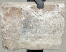
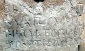
ST UM 6 Detail of ST UM 6
According to Chiara Lorenzini (referenced below, at p. 32), this inscription (ST UM 6, EDR 162789), which is now in the Museo Archeologico, Palazzo Trinci, Foligno, was:
-
“... found in 1928 in a field at Colle San Pietro, between Trevi and Sant’ Eraclio, in the locality of San Pietro in Flamignano, along [the eastern branch of] Via Flaminia, about 2 km from a fountain known locally as ‘Petruio’” (my translation).
The text, which is in the Umbrian language and uses the Latin alphabet, reads:
bia . opset
marone/ t . foltonio/ se . ptrnio
The first line records the construction of something described as a ‘bia’ (probably a fountain) while the final two lines record the names of two marones (magistrates): T(itus) Foltonius; and Se(xtus) Petronius. This suggests that these ‘marones’ had commissioned the ‘bia’, although it is alternatively possible that their names were recorded merely as a dating device.
According to Simone Sisani (referenced below, 2007, pp. 381-2):
-
“[On the basis of paleographic analysis,] it is difficult to countenance a date later than [ca. 200 BC for this inscription]: a “terminus circa quem” [approximate date] is furnished by the opening of Via Flaminia [in 220 BC], with which the building project mentioned in the inscription could have been connected” (my translation).
Giulio Giannecchini (in L. Agostiniani et al., referenced below, at entry 33) also dated this inscription to the late 3rd century BC and associated it with the opening of the eastern branch of the Via Flaminia. Sisani (referenced below, 2007, at p. 142) reasonably suggested that its early use of the Latin alphabet was an example of the ‘Romanising’ effect of the opening of the road.
The title of the magistracy held by Foltonius and Petronius is obviously expressed in the Umbrian language. According to Simone Sisani (referenced below, 2007, at p. 249), after the Roman conquest:
-
“The administrative structure of [the Umbrian communities that still enjoyed nominal independence, albeit under Roman hegemony] appears to have been based on a college formed by two pairs of magistrates: the auctores [or uhteres]; and the marones. [The auctores seem to have been] the leading magistrates within the college. ... the marones seem to have been of an inferior status, with a function associated with ... public works” ” (my translation).
If this is correct, then Foltonius and Petronius held office in a substantial urbanised community that had not yet been incorporated into the Roman state. However, as discussed in the section below on the legal status of Fulginia, other scholars believe that ‘native’ magistracies such as theirs were sometimes retained after incorporation. A more immediate concern here is whether this inscription can be securely assigned the corpus of Fulginia, and thus that Foltonius and Petronius held office there.
Guy Bradley and Simone Sisani assumed that the find spot implied that this was the case, and this is indeed the generally accepted view. However, as discussed above, there is no other surviving evidence (epigraphic, documentary or archeological) for the existence of an urban centre of Fulginia at this early date.
-
✴This does not, of course, preclude the existence of Fulginia at this time.
-
✴What it does mean is that we should at least consider the possibility that the marones of ST UM 6 held office elsewhere.
The map above identifies other possible candidates near the find spot of the inscription. We might, in my view, reasonably exclude Forum Flaminii, Trebiae and Hispellum:
-
✴Forum Flaminii and Trebiae were probably established when the road was built and are therefore unlikely to have had magistracies designated in the Umbrian language.
-
✴Hispellum is no more visible than Fulginia in the epigraphic and documentary record of this period:
-
•There is archeological evidence of its urbanisation at this early date, but Filippo Coarelli (referenced below, at pp. 47-8), for example, believed that:
-
“The few remains [of the settlement before colonisation in ca. 40 BC] are not indicative of a city; they rather indicate a vicus ...” (my translation).
-
•There is no secure surviving evidence that it was self-governing before colonisation (albeit that three inscriptions recording quattuorviri after 90 BC belong to the corpus of either Hispellum of Mevania).
Filippo Coarelli (referenced below, at pp. 47-8) believed that:
-
“... the urban settlement of Hispellum assumed the dimensions and dignity of a city only with the foundation of the colony” (my translation).
In his view, the vicus of Hispellum, like the ancient sanctuary in the plain below it, probably belonged to Mevania.
It seems to me that, while we might reasonably exclude Forum Flaminii, Trebiae and Hispellum for the reasons above, we cannot exclude the possibility that the inscription belongs to the corpus of Mevania (some 12 km from the find spot), and thus that Foltonius and Petronius held office there. I must stress that I have never seen this suggestion in the literature: as will become clear below, scholars generally assume that Fulginia existed as a substantial urban entity by 220 BC and that Foltonius and Petronius were thus marones of this city in the late 3rd century BC.
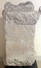
Cippus (ca. 200 BC)
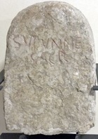
The inscription, which uses the Latin alphabet, reads:
SUPUNNE / SACR
It is not clear whether the language used is Umbrian or Latin: for example:
-
✴as noted above, Guy Bradley (at p. 285) listed it as an Umbrian inscription employing the Latin alphabet; while
-
✴the Eagle database (see the CIL link) asserts that it is in Latin.
Paolo Vitelozzi (in L. Agostiniani et al., referenced below, at entry 38) dated it to the end of the 3rd or beginning of the 2nd century BC.
It is likely that the cippus marked the boundary of an area that was sacred to an otherwise unknown goddess, Supunna. Maria Romana Picuti (referenced below, at p. 134) reproduced the early records of this inscription and the two main hypotheses relating to the identity of Supunna:
-
✴Alberto Calderini (referenced below, at p. 63) revived the traditional hypothesis that she was a river goddess (since ‘Supunna’ might associated with the ‘Tupino’, the Topino river of Foligno); this would be similar to the case of Clitumnus, a god associated with the nearby river of that name).
-
✴Paolo Vitelozzi (in L. Agostiniani et al., referenced below, at entry 38) referred to the hypothesis that the etymology suggested an old Latin verb ‘to throw’, which might indicate that Supanna was a goddess who presided over the preparation of food in the course of rituals of sacrifice.
This early use of the Latin alphabet, if not the Latin language, suggests the ‘Romanising’ effect of the opening of the eastern branch of Via Flaminia in 220 BC. It is difficult to extract more than this from the inscription: as Maria Romana Picuti (referenced below, at p. 135) pointed out:
-
“Unfortunately, neither the archaeological context [for the discovery of the cippus] nor the exact find spot is known. We are therefore not able to say whether there was a cult building dedicated to Supunna [within the putative sacred area that the cippus indicated]” (my translation).
This putative sacred area might have belonged to Fulginia, whether that centre was located at Santa Maria in Campis or at modern Foligno. However, as noted above, we have no secure documentary of archeological evidence for the existence of Fulginia in either location at this time.
Epigraphic Record of Fulginia: My Conclusion
Both of these inscriptions were found at or close to the location of Fulginia as suggested by the Itinerarium Burdigalense (333 AD). Thus, despite the lack of evidence for the existence of Fulginia in the 3rd century BC, they probably do belong to the corpus of Fulginia. Unfortunately, neither provides hard evidence for its precise location.
Fulginia in the Second Punic War (218 - 201 BC)
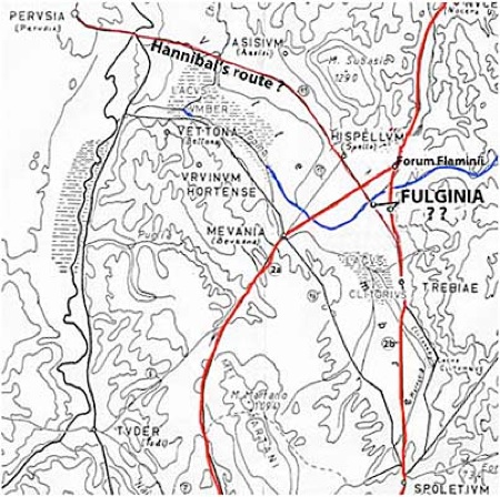
Hypothetical location of the Lacus Umber [credit needed]
Via Flaminia is indicated here in red, on the assumption that both branches existed at this time
In 217 BC, Hannibal famously crossed the Alps into Italy and inflicted a series of defeats on the Romans. The most devastating of these occurred at Lake Trasimene, some 50 km northwest of modern Foligno. As mentioned above, Caius Flaminius, the builder of Via Flaminia in 220 BC and now the Roman general opposing Hannibal, was killed during this battle. As noted above, we can probably discount the claim by Silius Italicus that Fulginia was among the Umbrian towns that sent soldiers to reinforce the Romans at the Battle of Cannae (216 BC) in Apulia. However, if it existed on or near the eastern branch of Via Flaminia at this time, it is unlikely to have survived the aftermath of the Battle of Trasimene unscathed.
Hannibal in Umbria (217 BC)
Another disaster followed in the wake of the Flaminius’ defeat at Trasimene: according to Polybius:
-
“About the same time as the battle, the [other] consul Gnaeus Servilius, who had been stationed on duty at Ariminium, ... having heard that Hannibal had entered Etruria and was encamped near Flaminius, designed to join the latter with his whole army. But, finding himself hampered by the difficulty of transporting so heavy a force, he sent Gaius Centenius forward in haste with 4,000 horse [as an advance party]. But Hannibal, getting early intelligence [of this development]..., sent Maharbal with his light-armed troops and a detachment of cavalry. Maharbal ... killed nearly half [of Centenius’] men at the first encounter; and, having pursued the remainder to a certain hill, took them all prisoner on the very next day. The news of the battle of [Trasimene] was only three days' old at Rome, and the sorrow caused by it was, so to speak, at its hottest when this further disaster was announced” (‘Histories’, 3: 86).
Livy gave a similar account of this second disaster:
-
“[Soon after the defeat at Trasimene] ... another unexpected defeat was reported [at Rome]: 4,000 horse, which had been sent under the command of [Gaius] Centenius, propraetor, by the consul Cnaeus Servilius [to reinforce Flaminius] were cut off by Hannibal in Umbria, to which place, on hearing of the battle at [Trasimene], they had turned their course” (‘History of Rome’, 22:8).
Livy did not record the place from which Servilius had sent Centenius, and (unlike Polybius) he gave the victory over the latter to Hannibal himself, rather than to Maharbal. He added the important detail that Centenius’ defeat had occurred in Umbria.
Appian was more specific (although not necessarily more accurate) about these events. He had the other consul Servilius based on the Po (rather than at Ariminum) as Hannibal approached, while Centenius was living as a private citizen in Rome:
-
“The greater part [of the Roman army] was dispatched against Hannibal under [the consuls] Gnaeus Servilius and Gaius Flaminius ... Servilius hastened to the Po ... [and] Flaminius, with 30,000 foot and 3,000 horse, guarded Italy within the Apennines .... Thus had the Romans divided their large armies ... Hannibal, learning this fact, moved secretly in the early spring, devastated Etruria, and advanced toward Rome. The citizens became greatly alarmed as he drew near, for they had no force at hand fit for battle. Nevertheless, 8,000 of those who remained were brought together, over whom Centenius, one of the patricians, although a private citizen, was appointed commander ... [this force was] sent into Umbria to the Plestine marshes, to occupy the narrow passages that offered the shortest way to Rome” (‘War against Hannibal’, 9).
Appian also gave an account of the subsequent battle:
-
“When Hannibal saw the Plestine marsh and the mountain overhanging it, with Centenius between them guarding the passage, he ... sent a body of lightly armed troops under the command of Maharbal to explore the district and to pass around the mountain by night. When he judged that [these troops] had reached their destination, he attacked Centenius in front. ... The Romans, thus surrounded, took to flight, and there was a great slaughter among them: 3,000 being killed and 800 taken prisoners, while the remainder escaped only with difficulty” (‘War against Hannibal’, 11).
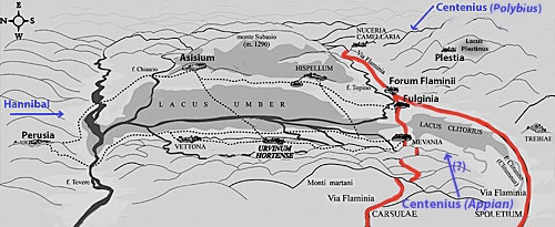
It is difficult to see how Appian’s account could make topographical sense, since the Lacus Plestinus (the later site of Plestia, marked at the upper right in the sketch map above) did not block Hannibal’s route from Trasimene to Rome. As Ronald Syme (referenced below, at p. 285) observed:
-
“.. for various reasons, it seems unlikely that the [second] catastrophe occurred precisely at the lake of Plestia: the time interval for Maharbal to get from Trasimene to Plestia and for the news to be carried to Rome will not fit Polybius’ indication... Most scholars therefore discount Plestia and put the disaster of Centenius further westwards, in the direction of Perusia.”
Ronald Syme (as above) continued:
-
“However it be [i.e. even if his account was inaccurate in important respects], Appian has preserved a valuable geographical detail. Though prone to all manner of error and confusion, he need not be accused of ‘inventing’ the lake of Plestia. The very oddity of the detail inspires a certain confidence.. How the story came to include the lake baffles conjecture. Perhaps Centenius had marched not by the Flaminia but by the Camerinum road.”
Guy Bradley (referenced below, at p. 148) also pointed out that some scholars think that Appian had confused the Lacus Plestinus with the Lacus Umber. Bradley himself was unconvinced, and Nereo Alfieri (referenced below, a paper that I have not been able to consult directly) argued that the Lacus Plestinus should be retained as the location of the battle. However, as discussed below, it does seem to me to be more likely that Centenius had occupied the passage along the shore of the Lacus Umber in an attempt to prevent Hannibal from reaching Via Flaminia. Thus, in my view, this battle might well have taken place on the north shore of the Lacus Umbra, below Asisium.
According to Livy, immediately after these victories:
-
“Hannibal, marching directly through Umbria, arrived at Spoletium. Having completely devastated the adjoining country, he began an assault upon the city but, having been repulsed with great loss and [recognising for the first time?] from the strength of this one colony ... [the difficulty of taking] Rome, he turned aside into the territory of Picenum ...” (‘History of Rome’, 22:9).
Polybius apparently had a different source for the sequence of events that followed the defeat of Centenius:
-
“Feeling now entirely confident of success, Hannibal rejected the idea of approaching Rome for the present: he traversed the country, plundering it without resistance, directing his march towards the coast of the Adriatic. Having passed through Umbria and Picenum, he came upon the coast after a ten days' march” (‘Histories’, 3: 86).
Scholars are not unanimous about the significance of these two accounts:
-
✴John Lazenby (referenced below, at p. 66) observed that:
-
“Although there is no direct conflict [between them] ..., a march from Lake Trasimene to the Adriatic via Spoletium [as reported by Livy] is well nigh impossible to reconcile with Polybius’ statement that Hannibal reached the sea [in only 10 days] ...”
-
He privileged Polybius’ account, which implies a much more direct march to the coast, although he conceded that Hannibal might still have sent a raiding party to Spoletium.
-
✴However, Guy Bradley (referenced below, at p. 150) pointed out that:
-
“Polybius could be taken as referring to [a march of] ten days from the siege of Spoletium [to the coast].”
-
✴Simone Sisani (referenced below, 2007, at p. 125) similarly accepted Livy’s account, suggesting that Hannibal had probably marched along the eastern branch of Via Flaminia in order to reach Spoletium (as noted above).
My View
Detail from Paul Fontaine (referenced below, appended map of western Umbria)
Fontaine located Fulginia at Santa Maria in Campis, on the eastern branch of Via Flaminia
I have added the alternative possibility: the site of modern Foligno, on the eastern side of the Tinia/ Topino
I have suggested the route of Hannibal’s march after Trasimene in 217 BC
After Hannibal had defeated:
-
✴Flaminius, at Lake Trasimene, some 40 km west of Perusia; and then
-
✴Centenius, probably on the northern shores of the Lacus Umber, below Asisium;
he continued either:
-
✴to Picinum and the Adriatic coast [Polybius]; or
-
✴to Spoletium [Livy].
In either event, we might reasonably assume that his route eastwards initially took him below Perusia and then along the road marked on the plan above:
-
✴Paul Fontaine (referenced below, at p. 39) described this as a Roman road that linked Perusia to Asisium, Hispellum and Spoletium, avoiding marshy areas; and
-
✴Paolo Camerieri (referenced below, 2015, at p. 85) pointed out that the present Ponte di San Giovanni dell’ Acqua in modern Foligno stands on the site of a ford in the Tinia (in its ancient course) that would have been used by travellers on this road.
From here, he could have taken:
-
✴the Apennine pass at modern Colfiorito, in order to reach the Adriatic coast; or
-
✴as Simone Sisani suggested (above), the eastern branch of Via Flaminia as far as Spoletium.
In either event, Fulginia (assuming that it existed at this point and was located at one of the two sites marked on the map) is unlikely to have escaped his attention, albeit that there is no mention of this in our surviving sources.
ANNIBAL/ CAESIS AD TRASIMENUM ROMANIS
URBEM ROMAM INFENSO AGMINE PETENS
SPOLETO/ MAGNA SUORUM CAEDE REPULSUS
INSIGNI FUGA PORTAE NOMEN FECIT
In my view, the Spoletans are surely correct: I find it impossible to believe that, while he was flushed with victory and the Romans were in disarray, he would not have pressed on immediately for Rome.
If, then, we accept Livy’s account, the Romans must have thanked their lucky stars that the walled Latin colony that had been established at Spoletium only 24 years earlier had blocked his advance. They must also have realised how vulnerable they were to future assaults along Via Flaminia, particularly along its less well defended western branch across Umbria. I suggest below that the sudden recognition of this strategic weakness might well have affected the subsequent history of Fulginia.
Tribal Allocation of Fulginia
C(aio) Anchario C(ai) f(ilio) Cor(nelia)/ Vero
dec(urioni) Fulg(iniae)
aed(ili) / F(oro)f(laminiensium)
It thus commemorates Caius Ancharius Verus, who had died while still only 22 years old. In his short life, he had served as both a decurion in Fulginia and an aedile in Forum Flaminii. Ancharius’ assignation to the Cornelia, rather than to the Oufentina, the tribe of Forum Flaminii, suggests that he came from Fulginia, which must therefore have been assigned to the Cornelia.
We might reasonably assume that Fulginia was assigned to the Cornelia when it became fully incorporated into the Roman state as a prefecture: as mentioned above, this incorporation probably pre-dated the Social War. In the section below, I discuss the main strands of modern scholarship in relation to the likely date at which this full incorporation took place.
Legal Status of Fulginia before the Social War
As discussed above, the only hard evidence we have for the legal status of Fulginia between the Roman conquest and the Social Wars comes from Cicero now-lost speech “Pro Vareno” , which Jane Crawford (referenced below, at p. 9) tentatively dated the trial to the period 77-6 BC. According to Priscian (‘Institutiones Grammaticae: de Nomine’ 2, 348, 18-20; search on “Fulginate”):
-
“Cicero ‘pro Vareno’: «G(aius) Ancharius Rufus fuit e municipio Fulginate»:
-
idem in eadem: «in praefectura Fulginate»”
which I translate as:
-
“Cicero, in ‘pro Vareno’: «G(aius) Ancharius Rufus was from the municipium of Fulginia; and, in the same work: «[something of relevance occurred] in the prefecture of Fulginia”.
The fortunate survival of this fragment thus reveals that the legal status of Fulginia had changed at some point during the time span of the events recounted by Cicero, albeit that both the direction of the change of status and its timing are matters for speculation. All we know with relative certainty is that, as discussed on the following page, Fulginia was a municipium administered by quattuorviri in the early imperial period.
There is certainly room for debate: for example, as noted above, according to Edward Bispham (referenced below, at p. 472), these fragments suggest that Fulginia was :
-
“... a municipium, but still subject to a [prefect] in the early 1st century BC.”
However, it seems to me that the most likely scenario is that put forward by both:
-
✴Guy Bradley (referenced below, at p. 143):
-
“Fulginia was probably a Roman prefecture until the Social Wars, after which it became a municipium”; and
-
✴Simone Sisani (referenced below, 2007, at p. 141):
-
“...the reference by Cicero to a ‘prefectura Fulginiatum’ should be related to the status of the settlement prior to the Social Wars” (my translation).
In other words, Cicero had given the court an account of relevant events that had taken place before the Social Wars, when Fulginia had been a prefecture, presumably as background to his version of the events surrounding the murder of ca. 80 BC, by which time Fulginia was a municipium.
What this surviving fragment does not tell us is when and in what circumstances Fulginia was designated as a prefecture. As already mentioned, the only potentially relevant information at our disposal comes from the inscription ST UM 6, which indicates that:
-
✴a substantial urban centre near the later site of San Pietro in Flamignano (between the modern cities of Foligno and Trevi) was administered by marones in ca. 220; and
-
✴that this centre is likely, although not certain, to have been Fulginia.
Modern Scholarship on the Legal Status of Fulginia
In the sections below, I summarise the different conclusions of four modern scholars: Giuliana Galli and Paolo Camerieri; Guy Bradley and Simone Sisani, on the legal status of Fulginia in the 3rd century BC. Each of them provided an extensive review of earlier work and thus, between them, capture the essence of most the modern debate.
Giuliana Galli and Paolo Camerieri
Topography of the putative Roman city of Fulginia on the site of of modern Foligno
Adapted from Paolo Camerieri (referenced below, 2015, p. 106, Figure 14)
I have added the question marks to the designations “Pertica of Fulginia ?”
My P(CM) = ford (later bridge) that took the cardo maximus of this putative Roman city across the Topino
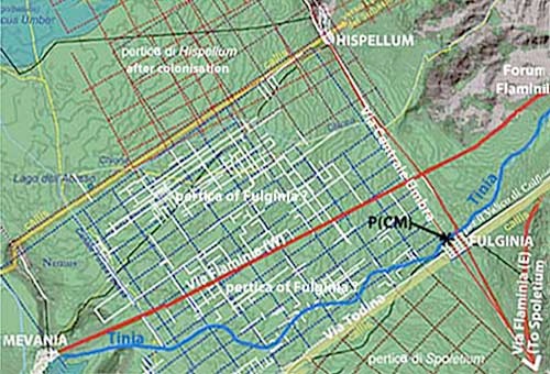
Giuliana Galli and Paolo Camerieri (in separate articles in the book edited by the former in 2015, referenced below) argued that the Romans established a castrum on the site of modern Foligno (the plan of which is, in their view, still reflected in part of the street of the city). Paolo Camerieri (2015, at p. 92) then made a very important observation: in his view, the junction of the ancient roads that related (respectively) to the deCumaenus maximus and the cardo maximus of the putative Roman city is almost a textbook example of an angulus clusaris (closing angle) of the centuriated area that can be identified to the west of modern Foligno (which I have marked ‘pertica of Fulginia ?’ in the plan above. He explained (at p. 77, note 111) that:
-
“[Fulginia] was not identified [as a possible owner of this land in earlier research, in which] the whole plain between Bevagna and the Via Centrale Umbra [below Hispellum] was assigned to [Mevania] in an uncritical way. [This was because] most local scholars placed Fulginia at Santa Maria in Campis, on the [eastern branch of] Via Flaminia, and its territory was assumed to lie entirely on the [south side] of the Topino [Tinia]” (my translation).
However, he noted that there was no particular coherence between this centuration and the street plan of Roman Mevania, which led him to conclude that this territory had more probably belonged to Fulginia, which was thus (in his view) correctly located at modern Foligno.
Paolo Camerieri (2015, at pp. 85-7) deduced the circumstances in which the putative castrum was built from the orientation of this deCumaenus maximus. He began by asking rhetorically why:
-
“... the deCumaenus maximus , the most important street of a Roman city, coincided [in the case of Fulginia] with neither branch of Via Flaminia ...” (my translation).
Instead, it coincided with a road that he designated as Via Todina, and described as the ‘proto-Flaminia’. Since this road probably declined in importance after the establishment of the Latin colony of Spoletium in 241 BC and would certainly have been eclipsed by the construction of the Via Flaminia in 220 BC, he concluded (at p. 87) that the castrum must have been built before 241 BC. He then asked (again at p. 87):
-
“... which event would have been of such importance to determine such the early Romanisation of this part of Umbria?” (my translation).
His answer was that:
-
“The only likely event of which we are aware concerns the war between Umbrians and Romans, and in particular the battle that took place on the plain between Bevagna and Foligno in 308 BC [recorded by Livy ((‘History of Rome’, 9:41)]” (my translation)
He therefore suggested that the putative castrum at Foligno had originated with the camp that the consul Quintus Fabius Maximus Rullianus had been building when he was attacked by the Umbrians in 308 BC.
As noted above, the suggestion that Foligno had its roots in a Roman city of any kind is by no means universally accepted. However, the topographical link between:
-
✴the cardo maximus of this putative Roman city;
-
✴the ford (later bridge) that must have taken it it over the Tinia;
-
✴the orientation of Camerieri’s “Via Centrale Umbra” (Paul Fontaine’s road 15 in the maps above); and
-
✴the centuriation to the southwest of it (which had previously been assigned to Mevania);
is hard to deny. I will return to this point below: what is important here are the deductions that Paolo Camerieri and Giuliana Galli made from these topographical data as they relate to the legal status of Fulginia before the Social War.
Paolo Camerieri did not give a specific date at which, in his view, the putative castrum at Foligno was urbanised and established as a prefecture. He observed (at pp. 91-2) that:
-
“We do not know the legal form that Fulginia assumed in the act of its foundation, but ... it was in any case assigned a vast territory in the [plain between Mevania and Hispellum. This would have represented] a bridgehead of viritane settlement, probably under the jurisdiction of the Latin colony of Narnia [formed in 299 BC], governed as a Roman prefecture and soon entrusted to the military protection of the new Latin colony of Spoletium [formed in 241 BC]” (my translation).
I am not sure what is meant by this reference to the jurisdiction of Narnia. Putting that to one side, I assume from this passage that, in Camerieri’s view, Fulginia was “governed as a Roman prefecture”at least by 241, when it was entrusted to the military protection Spoletium.
Giuliana Galli (referenced below, 2015, at p. 38) also summarised this model of this early history:
-
“... Fulginia, which was an obscure Umbrian centre in the period between the 10th and 4th centuries BC, was affected by the distribution of territory to Roman army veterans [in the early 3rd century BC: these veterans were settled on land that was] divided into centuries in the valley between Hispellum (Spello) ... and Mevania (Bevagna) and assigned to the Cornelia tribe. ... We do not know how the foundation act [of this urban centre] was framed from an administrative point of view, but it probably took the status of prefecture” (my translation).
In summary, if I have understood them correctly, Galli and Camerieri suggested that:
-
✴Roman veterans were settled in the plain between Mevania and Hispellum soon after the conquest and assigned to the Cornelia; and
-
✴an erstwhile castrum on the site of modern Foligno was established as a prefecture in order to administer their affairs; and
-
✴the land assigned to them was centuriated on a grid that was coherently oriented in relation to what had been the decumaenus maximus and the via principalis of the erstwhile castrum, now respectively the deCumaenus maximus and cardo maximus of the ‘new city’ of Fulginia.
In other words, within decades of the Roman conquest of Umbria, Fulginia was “born” as a Roman prefecture assigned to the Cornelia.
Evidence of ST UM 6
Giuliana Galli (referenced below, 2015, at p. 38 and note 33) was aware of the potential problem for this model that was posed by ST UM 6: a prefecture established for Roman veterans relatively soon after the conquest would surely not have been administered by marones in the early 3rd century BC. She addressed it by suggesting that, at some time before the date of this inscription:
-
“... according to [Cicero’s speech “Pro Vareno”], the city became a municipium and then again a prefecture: it is plausible that, after its initial foundation, Fulginia enjoyed a period of autonomy as a municipium with two or four local magistrates , becoming a prefecture again ... as punishment for the city’s rebellion, together with Spoleto, during the 1st century BC [presumably at the time of Sulla]” (my translation and my bold italics).
In other words, she assumed that Cicero’s reference to a prefecture of Fulginia (discussed above) indicated that this was its status at the time of his speech “pro Vareno” and that it had previously enjoyed a period of autonomy as a municipium with administered by a pair of marones and possibly two other magistrates whose magistracy was expressed in the Umbrian language. This putative period of autonomy presumably dated back until at least the date of ST UM 6.
I have to say that I find this scenario difficult to understand:
-
✴It is difficult to conceive of the circumstances in which a prefecture created soon after the conquest to administer the affairs of Roman settlers would have wanted or been given autonomy from Rome and constituted as a municipium administered by marones only a few decades later.
-
✴In any case, Cicero is our only source for the information that Fulginia ever had the status of a prefecture. If, as Galli suggested, he was referring to its status during a brief and otherwise undocumented period of ‘relegation’ after the Social War, then we have no basis for assuming it had ever held this status before this time.
In my view, if we accept the proposition of Giuliana Galli and Paolo Camerieri - that Fulginia was incorporated into the Roman state as a prefecture settled by Roman veterans assigned to the Cornelia soon after the Roman conquest - then we should probably conclude that the marones of ST UM 6 held office elsewhere.
Guy Bradley
According Guy Bradley (referenced below, at p. 139):
-
“... there is evidence ... that the pre-existing Umbrian [community] of Fulginia ... [was] incorporated [into the Roman state] with civitas sine suffragio [i.e. citizenship without voting rights] and that it [subsequently] became [a prefecture] in the period before the Social War.”
[I have edited out the parallel references to Plestia in this passage in the interests of clarity.] I am not sure what constitutes this evidence for the initial incorporation of Fulginia without voting rights, but it might have been a consequence of his assumption that it subsequently became a prefecture: he might have been following Michel Humbert (referenced below, at p. 3480), who asserted that:
-
“... the civitas sine suffragio represented a transitional phase, usually leading to a period of Romanisation ...and full citizenship” (my translation).
In relation to the likely date at which the initial incorporation of Fulginia occurred, Bradley suggested (at p. 140) that:
-
“The aftermath of the Battle of Sentinum [295 BC] seems ... a likely occasion, although it is also possible that [it] happened either: after the defeat [of the Umbrians] in 308 BC; or later than the defeat of the Sabines [in 290 BC].”
Guy Bradley then referred (at p. 144) to the following passage by Michel Humbert (referenced below, at p. 225):
-
“We propose to attribute the extension of political rights to the [erstwhile] cives sine suffragio of ... Fulginia to 22o BC [the period in which Fulginia was assigned to the Cornelia]” (my translation).
He (Bradley) summarised (at pp. 144-5) the arguments that underpin the hypothesis that Fulginia was assigned to the Cornelia at that time:
-
✴[These arguments] had begun with the work of Lily Ross Taylor (referenced below, at pp. 91-2), who observed that:
-
“Forum Flaminii, which was presumably founded by C. Flaminius on his great road [in ca. 220 BC], was in the Oufentina [tribe], which was also made the tribe of neighbouring Plestia.”
-
She suggested (at p. 306) that:
-
“[While] it is possible that the Oufentina ... was the tribe of Flaminius [himself], ... it is also possible that ... [this assignation simply] represented an attempt on [his] part ... to gain [political support] in certain tribes [including the Oufentina] by adding to them men who would be under obligation to him.”
-
Of course, now that the Via Flaminia existed, such men (presumably recent settlers from Rome) would find it relatively easy to return there in order to vote.
-
✴They had been taken forward by Michel Humbert (referenced below, at p. 225), who suggested that, in response, Lucius Aemilius Papus, who was Flaminius’ colleague as censor in 220 BC, arranged for Fulginia to be assigned to the Cornelia, the tribe of his (Aemilius’) allies, the Cornelii Scipiones”.
Bradley himself (at p. 145) considered these to be “plausible reconstructions”, which suggests that he too believed that Fulginia had been elevated to the status of a prefecture and assigned to the Cornelia in ca. 220 BC.
On this model, Fulginia had been a civitas sine suffragio in the period between the conquest and 220 BC. Bradley suggested (at p. 143) that the inscription ST UM 6 (above):
-
“... shows that [Fulginia] retained the Umbrian marones after its [initial] incorporation into the Roman state.”
He suggested (also at p. 143) that:
-
“... the praefectura [continued to be] governed by marones, who were replaced by quattuorviri when Fulginia became a municipium [after the Social War]”.
In other words, if I understand him correctly, Bradley assumed that Fulginia:
-
✴was incorporated into the Roman state without voting rights at the time of the conquest, albeit that it continued to be administered by local magistrates who kept the Umbrian title of marones;
-
✴was given voting rights as a prefecture and assigned to the Cornelia in ca. 220 BC, but retained its marones; and
-
✴became a municipium administered by quattuorviri after the Social Wars.
Simone Sisani
In sharp contrast, Simone Sisani (referenced below, 2007, at p. 142) argued that:
-
“The use of the Umbrian language [in the inscription ST UM 6] and, above all, the ‘local’ nature of its administration [by marones], make it certain that Fulginia was still an autonomous centre [in ca. 220 BC]” (my translation and my bold italics).
On this model, Fulginia was not incorporated into the Roman state until some time after 220 BC, when it became a prefecture and was assigned to the Cornelia.
For Simone Sisani (referenced below, 2007, at p. 218), this could not have taken place in 220 BC (as Micel Humbert had suggested): the fact that the adjacent centres of Forum Flaminii and Fulginia were assigned to different tribes was :
-
“... explicable only by separating the colonising initiatives that were responsible for the extension of the two tribes [the Oufentina and the Cornelia] into the area. [This] is confirmed by the different chronologies that can be deduced for these extensions:
-
•while Forum Flaminii was certainly established in 220 BC;
-
•the prefecture of Fulginia could not have been established before the end of the 3rd century BC, when it was still administered [by marones, as evidenced by ST UM 6]” (my translation).
Simone Sisani argued that the subsequent establishment of the prefecture of Fulginia:
-
“... can be closely associated with the viritane settlement in 200-199 BC of veterans of the war against Hannibal. This is confirmed by the assignation of Fulginia to the Cornelia, ... which was probably [the tribe] of the instigator of this settlement, P. Cornelius Scipio Africanus” (my translation).
In order to substantiate his hypothesis, Sisani pointed out that, according to Livy’s account of the events of 199 BC, when Scipio Africanus held the post of princeps senatus, the praetorship of Caius Sergius Plautus was extended into the following year:
-
“... so that he might superintend the distribution of land to the soldiers who had served for many years in Spain, Sicily, and Sardinia ...” (‘History of Rome’, 32: 1: 6).
Sisani reasonably suggested that Scipio had probably arranged for Sergius’ term of office to be prorogued in order facilitate the settlement of his own veterans, and hypothesised that Fulginia’s assignation to the Cornelia tribe suggests that some of these veterans were settled here.
In other words, in Sisani’s view, Fulginia:
-
✴continued after the conquest as a nominally independent centre administered by marones, a situation that pertained until at least 220 BC;
-
✴received veteran settlers who were assigned to the Cornelia in ca. 199 BC, at which point it lost its administrative autonomy and became a prefecture; and
-
✴became a municipium administered by quattuorviri after the Social Wars.
Legal Status of Fulginia: My View
Thus we have three distinct hypotheses relating to the date at which Fulginia became a prefecture:
-
✴at some time between the Roman conquest and ca. 241 BC (Galli and Camerieri);
-
✴in 220 BC, after an earlier period that began soon after the conquest during which it was a civitas sine suffragio (Bradley);
-
✴after ca. 220 BC, the likely date of ST UM 6, probably in ca. 199 BC, when (in Sisani’s view) veterans of the army of Scipio Africanus were settled in the Valle Umbra (Sisani).
If Simone Sisani was correct when he asserted that the evidence of ST UM 6 makes it certain that Fulginia was still an autonomous centre in the late 3rd century BC, then the first two hypotheses can be discarded.
Epigraphic Evidence for Uhteres and Marones
As noted above. Simone Sisani (referenced below, 2007, at p. 249) asserted that, after the conquest:
-
“The administrative structure of [the Umbrian communities that still enjoyed nominal independence, albeit under Roman hegemony] appears to have been based on a college formed by two pairs of magistrates: the auctores [or uhteres]; and the marones. [The auctores seem to have been] the leading magistrates within the college. ... the marones seem to have been of an inferior status, with a function associated with ... public works” ” (my translation).
In fact, we know of four cities in Umbria, in addition to the city of ST UM 6, that were administered by uhteres and/ or marones at some time before the Social Wars:
-
✴Iguvium (Gubbio): the Iguvine Tables mention uhteres and, since those in Table Va seem to have been named as a dating device, these were probably secular magistrates. This table, which uses the Latin alphabet, was probably inscribed in the 2nd century BC, but its text was probably taken from an earlier source.
-
✴Mevania (Bevagna) was the source of two relevant inscriptions:
-
•ST Um 25 (2nd century BC), a funerary inscription from Bevagna that uses an Etruscan alphabet, commemorates a uhter: and
-
•AE 1965, 279a, a Latin inscription from the municipal period that was found at Montefalco (which probably belonged to Mevania at that time), identified a now-anonymous ‘marone’ whose anachronistic designation as a marone probably harked back to an earlier magistracy with this title at Mevania.
-
As noted above, we cannot rule out the possibility that ST UM 6 related to Mevania.
-
✴Tadinum (Gualdo Tadino): ST UM 7 (probably late 2nd century BC), which came from the way station of Helvillum on Via Flaminia and which used the Latin alphabet, records a bia (fountain) dedicated to the Umbrian goddess Cupra and a cistern that was built at a specified cost in the period of office of two named marones who probably held office at Tadinum (some 9 km south of Helvillum).
-
✴Asisium (Assisi) was also the source of two relevant inscriptions:
-
•CIL XI 5390 (140 -100 BC), a Latin inscription that survives in situ in the Duomo of Assisi, records the building of a cistern and a terrace wall and names six marones, who are usually assumed to have held office in pairs in three consecutive years; and
-
•ST Um 10 (120 - 90 BC), an inscription that uses the Latin alphabet and was found at Ospedalicchio, near Bastia (between Assisi and Perugia), refers to a piece of land that had been bought and delimited by (or during the year in office of) two named uhteres and two named marones.
-
Since Nero Babrius was named as a marone in CIL XI 5390 and as a uhter in ST UM 10, we know that both inscriptions record magistrates of Asisium.
As far as we know, Iguvium, Mevania and Asisium all remained nominally independent until the Social War, when they became municipia administered by quattuorviri. Thus:
-
✴all of them were autonomous at the dates of the respective inscription; and
-
✴the evidence from Assisi suggests thatthey retained the designations ‘uhter’ and ‘marone’ for their magistrates until the Social War.
The case of Tadinum is less clear, since another inscription (CIL XI 5802, 30 BC - 30 AD) from Costacciaro (which was some 17 km north of Tadinum) commemorates the duovir Cnaeus Disinius:
-
✴According to Guy Bradley (at p. 139), this magistracy was typical of centres that had had Roman status before the Social War. If this is correct, and if Disinius was a duovir of Tadinum in the early imperial period, then Tadinum might have been incorporated into the Roman state before the Social War. Guy Bradley (again at p. 139) considered this hypothesis to be suggestive and observed (at note 121) that:
-
“The marones of [ST UM 7] surely also pertain to Tadinum, which would mean that this centre retained its native magistracy [after its putative early incorporation into the Roman state]; these [marones] would, on this interpretation, have become duoviri on municipalisation.”
-
✴However, it is by no means certain that Disinius was a duovir of Tadinum: for example, Maria Carla Spadoni (in L. Rosi Bonci and M. C. Spadoni (Eds), referenced below, at pp. 229-30, entry 3) suggested that he had more probably been a duovir of Arna, and pointed out that there is no hard evidence to suggest that Tadinum was other than a municipium administered by quattuorviri at the time of CIL XI 5802.
Thus, in all probability, all four of these centres - Iguvium, Mevania, Tadinum and Asisium - were nominally autonomous centres administered by uhteres and/ or marones, at least until the dates of the respective inscriptions and probably until they were incorporated into the Roman state following the Social War.
The ‘Oscan’ Meddices
The word meddix (magistrate) has been recorded in many Oscan-speaking cities and indeed, there is early evidence of meddices at Umbrian-speaking Asisium (prior to the emergence of Umbrian uhteres and marones there, as discussed above). This term was often qualified by an adjective, as in meddix tuticus (chief magistrate). In the present context, it would be interesting to know whether this magistracy (or, at least, its Oscan designation) survived the incorporation into the Roman state of the cities in question.
There is at least one case in which it certainly did: Henrik Mouritsen (referenced below, at p. 151) described the case of Capua, which was incorporated in 338 BC and is:
-
“... the only civitas sine suffragio known to us in any detail: ... [By] the time that [it had defected to] Hannibal in 216 BC, it appears very much to have been a self-governing Oscan-speaking community. It maintained its own traditional magistrates [led by a meddix tuticus] ... ” (see, for Livy, ‘History of Rome’, 23: 5.9 and 26:6.13).
Edward Salmon (referenced below, at p. 86) noted that:
-
“At Capua, there was a single meddix tuticus Campanus until the Romans suppressed its local government [after the failure of the revolt] in 211 BC” (my changed order of phrases).
In other words, the Capuans were administered by a meddix tuticus for more than a century after their incorporation, and only forfeited this privilege when they rebelled against Rome.
However, Adrian Sherwin-White (referenced below, at p. 205) referred to two classes of civitates sine suffragio:
-
✴The first class, to which Capua belonged, which:
-
“... secured the status in more or less friendly circumstances and retained full local autonomy, [were located] principally in Campania and Volscium ...”
-
✴The second class comprised:
-
“... those [centres] on which the status was thrust or whose status was altered after rebellion, reconquest, and confiscation of lands. [They] were allowed only a reduced measure of autonomy or none at all ... , their existing magistracies being frequently limited to priestly functions.”
Although detailed evidence is had to come by (particularly in the period 292-218 BC, in which Livy’s accounts are lost), we might reasonably assume that most of those civitates sine suffragio that were created at Oscan-speaking centres in the 3rd century BC, when the dominance of Rome within peninsular Italy was established, belonged to the second class.
[According to Nikoletta Farkas (referenced below, at p. 21, note 46):
-
“An inscription (ST Sa 17) from Aufidena attests the office of meddix tuticus [chief magistrate, expressed in the Oscan language] at a time when the town probably was a praefectura.”]
The ‘Sabine’ Octovirate
Ronald Syme (referenced below, at p. 295) observed that:
-
“A peculiar form of magistracy, the octovirate, is found in the imperial age in certain Sabine communities [that share] a common history: they had all been incorporated in the first instance with the civitas sine suffragio [and then] advanced rapidly to the full citizenship but continued to be prefectures. Octoviri are attested at [Sabine] Amiternum, Trebula Mutuesca and Nursia, and also at Interamna Praetuttiorum, which .... might not unreasonably be described as originally Sabine. .... There were also octoviri at Plestia in Umbria ... Not that this debilitates the view that octoviri are an ethnic or regional phenomenon, ... : Plestia is contiguous with the north of Sabine country.”
Syme pointed out that the octovirate has been the subject of prolonged discussion and sharp disagreement. He then addressed the two main streams of scholarship on the matter:
-
✴He observed that:
-
“One theory maintains that [the octovirate] was a type of of municipal constitution imposed by [Rome] in prefectures at a definite period in the 3rd century BC.”
-
This theory probably originated with Hans Rudolph (referenced below, 1935): I have not been able to consult this book but, in a review of it, Henry Stuart Jones (referenced below, at p. 269) expressed his opinion that:
-
“[Rudolph] ... makes out a strong case for the view that [the octovirate] was imposed by Rome in 268 BC, not only on the three Sabine [orefectutres] of Amiternum, Nursia and Trebula Mutuesca, but on all communities [that Rome] admitted to her citizenship [at that time].”
-
However, for Syme:
-
“[Rudolph’s] view presupposes much more plan and uniformity in Roman dealings with local affairs than is proved or plausible.”
-
✴He was therefore of the opinion that:
-
“There is more to be said for the traditional assumption [which was first articulated by Arthur Rosenberg (referenced below, 1913),] that the octovirate was an ethnic (or at least a regional) form of magistracy that survived where it had grown up and was not disturbed by [Rome]. [After all], who cared?”
-
This was also apparently the view of Adrian Sherwin-White (referenced below, at p. 66), for whom:
-
“... the words octovir [and, at other centres, aedilis] are admittedly translations of [pre-Roman] terms [that are] unknown to us, introduced with the advancing Latinisation of the peninsular.”
-
However, not everyone accepted Rosenberg’s view: for example, Henry Stuart Jones (as above) asserted that:
-
“[Rudolph] is doubtless right in rejecting Rosenberg’s theory of the Sabine origin [of the octovirate].”
More recently Guy Bradley (referenced below, 2000, at p. 140), who considered both schools of thought, concluded that:
-
“It is not known for certain whether the octovirate was:
-
- created by the Romans [as Rudolph proposed]; or
-
- a local magistracy from the pre-Roman period whose name was [subsequently] Latinised [as Rosenberg proposed].”
Edward Bispham (referenced below, 2008, at p. 372 , note 200) plumped for Rudolph:
-
“[Arthur] Rosenberg saw the quattuorvirate as an evolution of the octovirate; rather [by which I think he means ‘more correctly’], some octoviral municipia became quattuorviral at a later stage in their evolution. The two magistracies probably do have in common [the fact] that they were, in a sense, artificial Roman creations applied to different geographical areas: in the case of the octovirate, probably meeting a requirement generated by a scattered settlement pattern of the territories concerned” (my bold italics).
In short, opinion remains divided. Obviously, if Rosenberg and Syme are correct, then the presence of octoviri in Italy possibly indicates the survival of ethnic magistracies after incorporation. However, I use the word “possibly” here because, even if we discount Rudolph’s alternative theory, we must still remember that:
-
✴We have no documentary evidence for the octovirate and our understanding of it derives entirely from inscriptions.
-
✴Although these surviving inscriptions mostly come from centres that were incorporated at an early date, those that can be dated belong to the imperial period. We thus have no evidence of any kind for the putative Oscan precursors of the octoviri.
-
✴In at least some cases, the recorded octoviri might have belonged to non-decurial, possibly priestly, colleges. Again, not everyone would accept that:
-
•Simone Sisani (referenced below, 2010, at p. 192 and note 118) asserted that those octoviri in the centres that he had analysed that were not explicitly designated as octoviri Augustales were magistrates.
-
•Amanda Coles (referenced below, at p. 194) argued that this might well have applied in other centres, even when the octovir in question was a freedman. Specifically, she noted that:
-
“... there are three libertini octoviri, [in surviving inscriptions] from: [Plestia] and Ameria in Umbria; and from Trebula Mutuesca in Samnium”;
-
but concluded (at p. 195) that, since there are known cases in yet other centre in which freedmen held other decurial offices:
-
“... the [octovirate] at Ameria, [Plestia] and Trebula Mutuesca ...need not be dismissed as a religious office, merely because freedmen held it.”
-
Note that Coles’ inscription I 21 (AE 1991, 646), which she attributed to Fulginia, actually came from nearby Plestia (modern Colfiorito), and I have amended the passages above accordingly, replacing ‘Fulginia’ by [Plestia].
-
However, leaving status aside, we cannot assume that octoviri (as opposed to as octoviri Augustales) were necessarily magistrates: after all, the term seviri was used in some centres for colleges that were functionally analogous to the seviri Augustales or Augustales in others (often described collectively as “*Augstales”, as in Margaret Laird, referenced below, at p. 5, note 12).
All this boils down to the fact that it is possible, but not certain, that the ‘Sabine’ octovirate indicates, at least some cases, an ethnic magistracy that survived incorporation into the Roman state. However, while (as noted above) we have documentary and epigraphic evidence for meddices, uhteres and marones in the Republican period, we have no indication of either:
-
✴the ethnic name(s) of the putative precursors of the ‘Sabine’ octovirate; or
-
✴how long these names survived after incorporation before they were Latinised.
Thus, the little we know about this Sabine experience throws little, if any, light on the question under discussion here: whether Umbrian magistracies (uhteres and marones) survived without Latinisation at centres incorporated into the Roman state and, if so, for how long.
Legal Status of Fulginia before the Social War: My Preliminary View
The epigraphic evidence (assembled above) does not, of course, prove without doubt Sisani’s assertion that uhteres and marones held office only in nominally autonomous Umbrian cities. However:
-
✴this was certainly the situation at Iguvium, Mevania and Asisium and probably the also at Tadinum; and
-
✴we have no surviving epigraphic evidence for these magistracies in any Umbrian centre at a time that it had certainly been incorporated into the Roman state.
Thus, it seems to me that, at least on the basis of the evidence from Umbria, we must assume that:
-
✴either ST UM 6 does not belong to the corpus of Fulginia;
-
✴or, following Simone Sisan, Fulginia was incorporated into the Roman State only after 220 BC, the probable terminus post quem for ST UM 6.
Of these, the second scenario seems to be the more likely. My attempt to look for evidence further afield taht might preclude this “working assumption” was hardly comprehensive. However, I have not found anything yet that suggests that ethnic magistracies elsewhere survived incorporation for significant periods, at least in centres that were incorporated in or after the 3rd century BC.
In short, it seems likely that Fulginia was first incorporated into the Roman state at some time in the period 220 - 90 BC. Simone Sisani (referenced below, at pp. 142) narrowed the range somewhat by pointing out that Quinus Satilienus , who was recorded in Rome with senatorial status in 140 BC, belonged to the Cornelia and probably came from Fulginia. He therefore suggested that the incorporation occurred at some time on the period 220 - 140 BC:
-
“... probably as a consequence of viritane settlement in the area ...”
Thus, we need to consider when within this period such settlement might have taken place. Before addressing this question, I would like to revisit the suggestion of Giovanna Galli and Paolo Camerieri (above), that the centuriation to the west of modern Foligno significantly pre-dates this period.
Castrum at Foligno ?
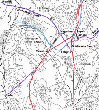
Detail from Paul Fontaine (referenced below, appended map of western Umbria)
Fontaine located Fulginia at Santa Maria in Campis, on the eastern branch of Via Flaminia
I have added the alternative possibility: the site of modern Foligno, on the eastern side of the Tinia/ Topino
As noted above, Giuliana Galli and Paolo Camerieri, in a series of articles in two books (referenced below, 2015 and 2016), hypothesised the existence of a Roman castrum that was:
-
✴built on the site of modern Foligno before 241 BC (and probably in 308 BC); and
-
✴subsequently urbanised as the prefecture of Fulginia, which administered the affairs of Roman citizens who had been settled on the centuriated area to the west.
Using the topographical information from Camerieri and Galli, I have located this putative castrum on Paul Fontaine’s map (above), at the junction of:
-
✴his road 15, which linked Perusia to Asisium, Hispellum and Spoletium; and
-
✴a hypothetical link between his roads 6 and 11, which Paolo Camerieri (2015, at pp. 85-7) designated as Via Todina. Camerieri characterised this as the ‘proto-Flaminia’, which connected Rome to the Adriatic coast via Tuder (modern Todi) and the Apennine pass at Plestia (near modern Colfiorito).
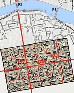
Inner two of the four bridges on the Tinia in its original course at Foligno (which I have labelled P2 and P3)
(after Luigi Crema, see G. Dominici, referenced below)
Putative castrum at Foligno, after P. Camerieri and G. Galli, (referenced below, 2015 and 2016), superimposed on an aerial view of the modern city
In the plan above, I have also located the putative castrum in relation to the inner two bridges at Foligno (which I have labelled P2 and P3) that span the canal that indicates the original course of the Tinia in its original course at Foligno: the upper part of this composite is from a drawing made by Luigi Crema that was published by Giovanni Dominici, referenced below). The present bridge P2, of which four out of the original five arches survive, is now known as the the Ponte di San Giovanni dell’ Acqua. Some scholars insist that the surviving structure is entirely medieval: for example, Matelda Albanesi (in Guerrini and Latini, referenced below, Appendix II, pp. 354-6) acknowledged that Luigi Crema had given it Roman origins, but she asserted that this view was erroneous. She commented (at p. 355), that the only excavations carried out so far:
-
“ ... revealed the western side of the bridge as far as the third arch, which presented (like the first arch) a rib of travertine blocks ... that probably derived from a Roman monument, evidence that has sometimes given rise to the erroneous dating of the work [to the Roman period]” (my translation).
Her reasons for assuming that the Roman masonry in question came from another monument (rather than, for example, from an earlier Roman bridge here) were unspecified. It seems to me that the evidence from the ancient road network insists that there must have been a bridge here from at least 220 BC.
It also seems to me that at least two things leap out from this topographical analysis:
-
✴this would have been an obvious location for a Roman castrum, offering excellent supply lines and a ready source of water for ditch-based defences; and
-
✴there is, indeed, a strong case to be made, at least in topographical terms, for the hypothesis that the plan of this putative castrum is still reflected in the street plan of modern Foligno (which does not, of course, allow us to ignore other evidence that might militate against this possibility).
Date of Construction of the Putative Castrum: My View
As noted above, Paolo Camerieri (referenced below, 2015, at pp. 91-2) believed that this putative castrum had been built in 308 BC and that putative prefecture that was subsequently established on the site represented:
-
“... a bridgehead of viritane settlement [that had been] ... entrusted to the military protection of the new Latin colony of Spoletium [in 241 BC] ....”
If so, one wonders why , despite its strategic location, it had apparently done little to oppose Hannibal in 217 BC: as discussed in the section “Second Punic War” and marked on the map above, his march from Trasimene would have taken him past Perusia and then:
-
✴along Fontaine’s road 15, below Asisium and Hispellum;
-
✴across the Tinia (using a bridge at P2 that would surely have replaced the ancient ford by this time);
-
✴along the cardo maximus of Camerieri’s putative prefecture; and
-
✴along the eastern branch of Via Flaminia to Spoletium (if Livy’s account is accepted).
It is certainly dangerous to argue from silence, particularly in the present context: as discussed above, our surviving sources give neither a complete nor a consistent account of these events. However, there is certainly no surviving evidence to suggest that a settlement on the site of modern Foligno that was under the military protection of Spoletium significantly impeded Hannibal’s advance. Perhaps this putative settlement did not (or did not yet) exist at this time?
As noted above, Paolo Camerieri (2015, at pp. 85-7) based his hypothesis of the dating of the castrum on the orientation of the deCumaenus maximus. He asked himself why:
-
“... the deCumaenus maximus, the most important street of a Roman city, coincided [in the case of Fulginia] with neither branch of Via Flaminia ...?” (my translation and my bold italics).
Instead, he pointed out that it coincided with his ‘proto-Flaminia’, which meant, in his view, that the castrum must have been built before 241 BC. In my view, this chain of reasoning overlooks the fact that, on Camerieri’s model, the original street plan was that of a Roman castrum that only subsequently became a Roman city. Its location and orientation would therefore have been determined by the strategic imperative of controlling the crossing of the Tinia. If so, then:
-
✴while its deCumaenus maximus (Camerieri’s ‘proto Flaminia’) would have determined its distance from the river;
-
✴its precise location would have been determined by the strategic need to locate its via principalis (later the putative cardo maximus of Fulginia) along the road across the river.
The aspect ratio of the rectangular castrum would have been decided:
-
✴not by the relative importance (in either logistical or strategic terms) of these two roads; but
-
✴by the need to defend as much as possible of its boundary by the river (rather than by moats fed from the river).
In other words, a castrum of this topography would have made strategic sense whether or not the longer of its two main axial roads was also its most important thoroughfare. It follows that 241 BC does not necessarily provide a terminus ante quem for the construction of the castrum. Indeed, its strategic value would have increased after 220 BC, since its via principalis would than have offered rapid access to both branches of Via Flaminia.
Thus, in my view, if the street plan of modern Foligno does indeed betray the existence of a Roman castrum, then this castrum was more probably built at some time after 217 BC, when Hannibal’s march on Spoletium would have demonstrated the strategic weakness associated with the recent construction of Via Flaminia: it is at least possible that the Romans responded to Hannibal’s wake-up call by building a permanently garrisoned camp here, from which soldiers could be quickly dispatch along the via principalis to defend either branch of the new road. The realisation that military fortifications were needed so close to Rome probably came as something of a shock. However, we might detect a similar reaction at nearby Asisium: Guy Bradley (referenced below, at p. 167) observed that the new circuit of walls there, which has been dated roughly to the middle of the 3rd century BC:
-
“... followed a course determined in places by defensive considerations rather than by the extent of habitable space. The scale of the wall and the antiquity of its conception has a great significance for this allied town. The immediate motive for the construction of the fortification may have been the renewed sense of danger emphasised by the invasion of Hannibal, who probably passed near Asisium after the battle of Trasimene.”
If we bring forward the date of construction of the putative castrum to ca. 217 BC, then we might align:
-
✴the hypothesis of Giuliana Galli and Paolo Camerieri, that this castrum gave rise to the subsequent establishment of a prefecture that administered the affairs of viritane settlers; and
-
✴the hypothesis of Simone Sisani, that establishment of this prefecture was associated with the viritane settlement of veterans of the Second Punic War at Fulginia.
Virtane Settlement in the Valle Umbra
As noted above, Simone Sisani (referenced below, 2007, at p. 218) argued that the establishment of the prefecture of Fulginia:
-
“... can be closely associated with the viritane settlement in 200-199 BC of veterans of the war against Hannibal. This is confirmed by the assignation of Fulginia to the Cornelia, ... which was probably [the tribe] of the instigator of this settlement, P. Cornelius Scipio Africanus” (my translation).
As Lily Ross Taylor (referenced below, at p. 307) pointed out:
-
“[While] there is no evidence for Scipio’s tribe, ... the Cornelia was the tribe of his gens ...”
Viritane Settlement of Scipio Africanus in the Valle Umbra ?
In the following passage, Paul Erdkamp (referenced below, at pp. 112-3) summarised two records from Livy that described the viritane settlement of veterans of Scipio Africanus in Italy after the Second Punic War:
-
“Livy tells us that:
-
✴In 201 BC [‘History of Rome’, 31: 4: 2] the Senate decided that the urban praetor should appoint a commission to supervise the measuring and division of public land in Samnium and Apulia on behalf of [those veterans of Scipio who had served in Spain and Africa].
-
✴[In a later record for 200 BC, ‘History of Rome’, 31: 49: 5], he adds that each veteran was offered 2 iugera for each year that he had served. ... some 40,000 veterans were [potentially] involved. However, apparently, not all of them accepted the offer, since some of Scipio’s veterans signed up for the Second Macedonian War (200-197 BC).
-
The point is that Roman veterans were settled on public land [on this occasion]. That they were not settled in colonies does not matter: at the end of the Hannibalic War the Senate probably saw no reason to found new military strongholds in Samnium and Apulia.”
Edward Salmon (referenced below. at p. 97) described the subsequent establishment of eight relatively small maritime colonies of Roman citizens in southern Italy after the Second Macedonian War: Volternum, Liternum, Puteoli, Salernum, Buxentum, Sipontum, Tempsa and Croto. The first five had been planned in 197 BC and all eight were established in 194 BC, the year of Scipio Africanus’ second consulship (see Livy: ‘History of Rome’, 32: 29: 3 for 197 BC and ‘History of Rome’, 34: 45: 1-5 for 194 BC). Salmon observed that:
-
“... it may be that this colonisation programme was a favourite project of [Scipio Africanus]. It is to be noted that, when he later fell out of favour, he retired to one of these colonies , ... Liternum ...”.
From these accounts, we can reasonably assume that Scipio did indeed take an active interest in the settlement of his veterans, and that this extended into the 190s BC.
Simone Sisani (referenced below, 2007, at p. 218) pointed out that, in 199 BC, when Scipio Africanus held the post of princeps senatus, the praetorship of Caius Sergius Plautus was extended into the following year:
-
“... so that he might superintend the distribution of land to the soldiers who had served for many years in Spain, Sicily, and Sardinia ...” (‘History of Rome’, 32: 1: 6).
He reasonably suggested that Scipio Africanus had probably arranged for Sergius’ term of office to be prorogued in order facilitate the settlement of his own veterans. David Gargola (referenced below, at p. 104) assumed that Livy’s three records of 201, 200 and 199 BC:
-
“... probably record the initial passage of a programme [of veteran settlement] and two later modifications to the project.”
This programme, as amended, might be have extended beyond Samnium and Apulia, although no other territories are identified.
Thus, there is no documentary evidence for Sisani’s hypothesis that Scipio’s programme extended into Umbria. He relied on circumstantial evidence:
-
✴Fulginia became a prefecture at some time in the period 220-140 BC; and
-
✴at least by the 1st century AD, it was assigned to the Cornelia, which was (as noted above) the tribe of Scipio’s family.
If one assumes (as many scholars do) that the tribal assignation coincided with the establishment of the prefecture, then the possibility that both events were connected in some way with the viritane settlement of Scipian veterans at Fulginia in ca. 200 BC emerges. Sisani further suggested (at p. 219) that:
-
“... the presence of settlers in the territory of [nearby] Mevania who were assigned to the Aemilia tribe can be ascribed to the same initiative. The ‘Scipian’ character of this tribe ... is evidenced by Scipio’s family ties to the gens Aemilia ... , [which were] established by his marriage to Aemilia Tertia, the daughter of Lucius Aemilius Paullus [before 215 BC]” (my translation).
There is circumstantial evidence that, on occasion, Scipio arranged for new tribal allocations that were to his political advantage. For example, according to Lily Ross Taylor (referenced below, at pp. 92-3):
-
‘Scipio’s veterans of the Spanish and African campaigns received grants from the ager publicus in Samnium and Apulia in 200 BC. ... [The tribes to which the resettled veterans were reassigned are unknown but, whatever they were] voters from the [two newly-enfranchised] regions would have added to the strength of Scipio in the comitia.”
She then described another example that is directly relevant to Sisani’s hypothesis:
-
“Scipio’s influence may also account for the assignment by a tribunical law of 188 BC of: Fundi and Formiae to the Aemilia; and Arpinum to the Cornelia. ... [The usual procedure would have been to assign these newly-enfranchised communities to neighbouring tribes, in this case, the Oufentina and Terentina, where they] would have had much less influence than they acquired when they were put into old rural tribes near Rome. The assignment of these three peoples to the Aemelia and the Cornelia ... [in Ross Taylor’s opinion] represented an attempt of Scipio Africanus to obtain control of tribal votes.”
However, once again the evidence is purely circumstantial: as Rachel Feig Vishnia (referenced below, at p. 156) pointed out, it relies (inter alia) on:
-
“... the unattested assumption that, originally, all Cornelii and all Aemilii had belonged to the tribes that bear their names [and the conjecture that these tribes] were under the sway of Scipio Africanus.”
Furthermore, she pointed out that:
-
“... if the Aemilia and Cornelia tribes were indeed already committed to Scipio, it would have been politically more astute to distribute new voters among other tribes whose support was presumably less reliable.”
Perhaps more fundamentally, nothing in surviving documents links Scipio to the tribunical law of 188 BC.
If this is accepted, then we still have to consider why, in contrast to any of the other four cities in the list above, Fulginia lost its nominal autonomy and was reconstituted as a prefecture before the Social War. In this context, we need to look in more detail at Simone Sisani’s hypothesis that the prefecture of Fulginia was established in association with the settlement of veterans in the early 2nd century BC, after the end Second Punic War.
In particular, since veterans of Scipio seem to have been settled at both Fulginia and Mevania in ca. 199 BC, why did Fulginia become a prefecture at this point while Mevania apparently retained its nominal autonomy ?
To take this further, we might usefully look at the case of what was probably the only other prefecture that was established in Umbria before the Social War: Interamna Nahars (Terni). Simone Sisani (referenced below, 2007, at p. 146) suggested that:
-
“... it is likely that [this urban] centre was born as a praefectura in coincidence with viritane settlement in the 3rd century BC” (my translation and my bold italics).
More specifically, he asserted (at p. 214), that:
-
“... the first viritane deductions in Umbria can be dated to the first three decades of the 3rd century BC, in strict rapport with the conquest and colonisation of the Sabine lands by [Manius] Curius Dentatus. A reflection of this activity seems to be the inclusion of Interamna in the Clustumina [tribe: this was also the assignation] of Sabine Forum Novum [some 30 km to the south], the creation of which is inseparable from the politics of the conquest carried out from 290 BC. ... it is possible that other contemporary deductions took place at this time in the fertile Conca Ternana, with the settlers assigned to the same tribe as their contemporaries in the adjacent Sabine lands: the putative prefecture of Interamna would have been created at this time” (my translation).
He also identified (at p. 147) the reason that Interamna had been established as a prefecture rather than (for example) as continuing as an Umbrian centre but with some of its territory assigned to viritane settlement, the pattern that seems to have applied at Mevania (above):
-
”The original settlements that are identifiable on the future site of the urban centre of Interamna ... had all been abandoned in or before the 6th century BC” (my translation).
In other words, since the Romans needed an urban settlement in this strategically important location for the purposes of administering the surrounding settlers, they had to create it themselves.
We therefor have to ask a wider question: why did both Interamna Nahars and Fulginia each lose its autonomy when it received veteran settlers, while Mevania (for example) apparently did not?
-
✴In the case of Interamna Nahars, this was probably because (unlike Mevania) it no longer exited as a substantial autonomous centre at the time of the viritane settlement.
-
✴Perhaps this was also true of Fulginia:
-
•perhaps it had never been a substantial Umbrian centre (in which case ST UM 6 would have recorded the marones of another centre, possibly Mevania); or
-
•perhaps it had been largely destroyed by Hannibal’s army in 217 BC, almost a decade before Scipio’s veterans arrived.
Legal Status of Fulginia: Summary of My View
Thus, it seems to me that we must envisage two alternative scenarios:
-
✴If one assumes that the marones of ST UM 6 had held office at Fulginia, then the history of this centre in the 3rd century BC can be tentatively summarised as follows:
-
ca. 295 BC - Fulginia became a federated ally of Rome, administered by marones
-
(probably in association with more senior uhteres).
-
ca. 220 BC - the marones of this nominally autonomous city (the precise location of
-
which is unknown) built a fountain on what was presumably a nearby site on the newly-opened eastern branch of Via Flaminia.
-
ca. 217 BC - Hannibal’s rampaging soldiers destroyed ‘Umbrian’ Fulginia before
-
marching on Spoletium.
-
✴If, on the other hand, one assumes that the marones of ST UM 6 had held office at another centre (perhaps Mevania), then we know nothing about Fulginia in the 3rd century BC. However, we might reasonably assume that, if it had existed in proximity to Via Flaminia in 217 BC, it was destroyed by Hannibal’s soldiers before they continued to Spoletium.
In my view, Simone Sisani is probably correct in asserting that veterans of Scipio Africanus were settled in the plain between Bevagna and Foligno in ca. 199 BC, some of whom were assigned to the Aemilia and others to the Cornelia:
-
✴The veterans assigned to the Aemilia were those settled on territory belonging to Mevania. There is nothing to suggest a change in the legal status of Mevania at this time: the native Mevanates were apparently assigned to the Aemilia only in the enfranchisement that followed the Social War.
-
✴However, the veterans assigned to the Cornelia were, in my view, settled on essentially uninhabited land that had assumed great strategic importance in 220 BC with the construction of Via Flaminia (as Hannibal had demonstrated only three years later). The settlement of veterans here at the end of the war would have addressed the security situation in this area, and it is likely that a new urban centre called Fulginia was established as a prefecture in order to administer their affairs.
Read more:
A. Coles, “Between Patronage and Prejudice: Freedman Magistrates in the Late Roman
Republic and Empire”, TAPA, 147:1 (2017) 179-208
P. Camerieri, Giovanna and Giuliana Galli (Eds.), “Dal Castrum alla via Quintana, dal Tempio alla Cattedrale: Studi Topografici e Architettonici tra Ambiguità Storiche e Anomalie Urbanistiche”, (2016) Foligno
R. Syme (the author, who died in 1999) and F. Santangelo (who edited these papers from the Ronald Syme archive), “Approaching the Roman Revolution: Papers on Republican History”, (2016) Oxford
G. Galli (Ed.), “Foligno, Città Romana: Ricerche Storico, Urbanistico e Topografiche sull' Antica Città di Fulginia”, (2015) Foligno, includes:
✴G. Galli, “Foligno Città Romana: Considerazioni sugli Studi Topografici e sulle Emergenze Archeologiche”, pp. 35-74
✴P. Camerieri, “Il Castrum e la Pertica di Fulginia in Destra Tinia”, pp. 75-108
M. Laird, “Civic Monuments and the 'Augustales' in Roman Italy”, (2015 ) New York
M. Romana Picuti, “Tra Epigrafia e Antiquaria: le Iscrizioni di Supunna e delle Cultrices Collegi Fulginiae nel De Diis topicis Fulginatium di Giacomo Biancani Tazzi”, in:
E. Laureti (Ed.), “G. Biancani: De Diis Topicis Fulginatium Epistola, Foligno 1761”, (2014 ) Spello, pp. 129-43
L. Rosi Bonci and M. C. Spadoni (Eds), “Arna: Supplementa Italica 27”, (2013) Bari
P. Guerrini and F. Latini, “Foligno: Dal Municipium Romano alla Civitas Medievale: Archeologia e Storia di una Città Umbra”, (2012) Spoleto
S. Sisani, “I Rapporti tra Mevania e Hispellum nel Quadro del Paesaggio Sacro della Valle Umbra”,, in
G. Della Fina (Ed.), “Il Fanum Voltumnae e i Santuari Comunitari dell’ Italia Antica”, (2012) Orvieto (pp. 409-64)
L. Agostinani et al. (Eds), “Screhto Est: Lingua e Scrittura degli Antichi Umbri”, (2011) Città di Castello
P. Erdkamp, “Soldiers, Roman Citizens, and Latin Colonists in Mid- Republican Italy”, 41 (2011) 109-46
L. Sensi (Ed.), “Discorso di Fabio Pontano sopra l’ Antichità della Città di Foligno”, (2008) Foligno
H. Mouritsen, “The Civitas Sine Suffragio: Ancient Concepts and Modern Ideology”, Historia: Zeitschrift für Alte Geschichte, 56:22 (2007) 141-58
S. Sisani, “Fenomenologia della Conquista: La Romanizzazione dell' Umbria tra il IV sec. a. C. e la Guerra Sociale”, (2007) Rome
R. Talbert, “Author, Audience and the Roman Empire in the Antonine Itinerary”, in
R. Hensch and J. Heinrichs (Eds), “Herrschen und Verwalten: Der Alltag der römischen Administration in der Hohen Kaiserzeit”, (2007) Cologne
N. Farkas, “Leadership among the Samnites and related Oscan speaking Peoples between the 5th and the 1st Centuries BC”, (2006) PhD thesis, King’s College, London
A. Calderini, “Iscrizione Umbre”, in”
M. Matteini Chiari (Ed.), “Raccolte Comunali di Assisi: Materiali Archeologici; Iscrizioni; Sculture; Pitture; Elementi Architettonici”, (2005) Perugia, pp. 51-78
F. Coarelli, "Il Rescritto di Spello e il Santuario ‘Etnico’ degli Umbri”, in:
“Umbria Cristiana: dalla Diffusione del Culto al Culto dei Santi,” Atti del XV Congresso Internazionale di Studi sull’ Alto Medioevo, (2001) Spoleto, pp. 39-52
G. Bradley, "Ancient Umbria", (2000) Oxford
D. Gargola, “Lands, Laws, and Gods: Magistrates and Ceremony in the Regulation of Public Lands in Republican Rome”, (1999)
C. Lorenzini, “Iscrizione dei Marones da San Pietro in Flamignano”, in:
“Fulginates e Plestini: Popolazioni Antiche nel Territorio di Foligno: Mostra Archeologica”, (1999) Foligno
L. Bonomi Ponzi, “Inquadramento Storico-Topografico del Territorio di Foligno”, in:
M. Bergamini (Ed.), “Foligno: La Necropoli Romana di Santa Maria in Campis”, (1998) Perugia, pp. 11-18
P. Camerieri, “Il Tracciato della Via Flaminia”, in
I. Pineschi (Ed), “L’ Antica Via Flaminia in Umbria”, (1997) Rome
N. Alfieri, “La Battaglia del Lago Plestino", Picus, 6 (1996) 7-22
R. Feig Vishnia, “State, Society and Popular Leaders in Mid-Republican Rome 241-167 BC”, (1996) Oxford
J. Crawford, “M. Tullius Cicero: The Fragmentary Speeches. An Edition with Commentary”, (1994) Atlanta
B. Lattanzi, “Storia di Foligno: Dalle Origini al 1305”, (1994) Foligno
P. Fontaine, “Cités et Enceintes de l'Ombrie Antique” (1990) Brussels
M. Frederiksen, “Campania” (1984) London
M. Humbert, “Municipium et Civitas sine Suffragio: L' Organisation de la Conquête jusqu'à la Guerre Sociale”, Publications de l'École Française de Rome, 36 (1978)
J. F. Lazenby, “Hannibal's War. A Military History of the Second Punic War”, (1978) Warminster
W. Harris, “Rome in Etruria and Umbria”, (1971) Oxford
L. Ross Taylor, “The Voting Districts of the Roman Republic: The 35 Urban and Rural Tribes”, (1960) Rome
A. N. Sherwin-White, “The Roman Citizenship”, (1939, revised 1973) Oxford
H. Stuart Jones, Review of H. Rudolph (1935), below), Journal of Roman Studies, 26.2 (1936) 268-71
G. Dominici, “Fulginia: Questioni sulle Antichità di Foligno”, (1935) Verona
H. Rudolph, “Stadt und Staat im Römischen Italien: Untersuchungen Über die Entwicklung des Munizipalwesens in der Republikanischen Zeit”, (1935), Leipzig
A. Rosenberg, “Der Staat der Alten Italiker. Untersuchungen uber die Urspriingliche Verfassung der Latiner, Osker, und Etrusker” (1913) Berlin
History of Fulginia: From Conquest to Municipalisation After Municipalisation
Location of Roman Fulginia Roman Walk I Roman Walk II Roman Walk III
Return to History of Foligno